
Satellite Data Derived Cyanobacteria Concentrations

Detailed Description
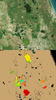
Two aerial images that demonstrate satellite-derived cyanobacteria concentrations in surface waters from an area in Florida. The top image is true-color photograph, and the bottom image is from the Medium Resolution Imaging Spectrometer (MERIS) sensor on the Envisat satellite, taken October 1, 2011. Data from the sensor lets scientists assign quantitative values for cyanobacteria concentrations, which are represented using a color scale ranging from blue (low concentrations) to red (high concentrations).
Sources/Usage
Public Domain.
Related

Remote Sensing Provides a National View of Cyanobacteria Blooms
Four Federal agencies, including the U.S. Geological Survey (USGS), are collaborating to transform satellite data into information managers can use to protect ecological and human health from freshwater contaminated by harmful algal blooms.
Related
Remote Sensing Provides a National View of Cyanobacteria Blooms
Four Federal agencies, including the U.S. Geological Survey (USGS), are collaborating to transform satellite data into information managers can use to protect ecological and human health from freshwater contaminated by harmful algal blooms.