
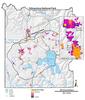
Satellite thermal infrared temperature map of Yellowstone

Detailed Description
Satellite thermal infrared temperature map of Yellowstone National Park's thermal areas. Maps like this can be used to assess changes in thermal areas over time, and also estimate the heat output from Yellowstone. Lakes and rivers are blue. The Yellowstone Caldera is black. Roads are yellow.
Sources/Usage
Public Domain.
Related

Hydrothermal Monitoring in Yellowstone National Park
Yellowstone was established as the world’s first national park primarily because of its extraordinary geysers, hot springs, mudpots and steam vents, as well as other geologic features. YVO scientists monitor these hydrothermal features as part of an effort to research and preserve them.
Related
Hydrothermal Monitoring in Yellowstone National Park
Yellowstone was established as the world’s first national park primarily because of its extraordinary geysers, hot springs, mudpots and steam vents, as well as other geologic features. YVO scientists monitor these hydrothermal features as part of an effort to research and preserve them.