
Thermal Imagery to Inform Brook Trout Habitat Suitability and Restoration Potential, Upper Namekagon River, Wisconsin
The U.S. Geological Survey (USGS), in cooperation with the National Park Service (NPS), is using thermal infrared technology to identify cold-water habitat for brook trout and other cold-water species in the upper Namekagon River in Wisconsin. The upper Namekagon River and its tributaries have long served as a stronghold for brook trout and other cold- and cool-water species; however, changing water temperatures have the potential to degrade cold-water habitat in the upper river. In addition, past impacts from logging activities, dams and other development have altered tributary inputs and natural spring flow. Improved information on the location and persistence of cold-water zones can help habitat restoration efforts and potentially brook trout sustainability.
Originating at Lake Namekagon in northern Wisconsin, the Namekagon River flows approximately 101 miles southwest before joining the St. Croix River. Both rivers are protected by the NPS as part of the St. Croix National Scenic Riverway. Brook trout rely on cold-water zones for survival. These cooler areas form where groundwater and smaller tributaries enter the river channel. Cold groundwater zones provide thermally stable, oxygen-rich habitats that are critical for reducing summer thermal stress, supporting successful reproduction, and sustaining trout populations under changing climate and flow conditions. Protecting and restoring these zones is essential for maintaining brook trout populations in the riverway. This project aims to identify the location of groundwater inputs within the Namekagon River channel to determine where cold-water habitat exists and where in-channel rehabilitation efforts by NPS would be most beneficial.
Objectives
The objectives of this study are to inform management strategies that protect and improve stream habitats in the upper Namekagon River by investigating the spatial distribution of cold-water refuges for brook trout and other cold-water species and identifying the locations of potential habitat loss due to river impediments or channel modifications.
Thermal imagery will be collected using a combination of handheld and uncrewed aircraft system (UAS) thermal sensors when the temperature contrast between surface water and groundwater is greatest.
USGS streamgage Namekagon River at Leonards, Wisconsin will be used to monitor surface water temperature and river conditions.
When combined with other limited temperature monitoring efforts on the Namekagon River, this project will support basic temperature modeling throughout the upper reaches to help identify areas most suitable for brook trout habitat. These data will also help inform other habitat restoration efforts meant to benefit multiple life stages of brook trout. Determining how and where the NPS may rehabilitate cold-water habitat will assist managers in determining how to protect native fish communities from threats due to climate change and habitat degradation. In addition to brook trout, this project will provide valuable information on suitable habitat for other species such as native mussels, aquatic invertebrates, amphibians, and reptiles using the riverway.
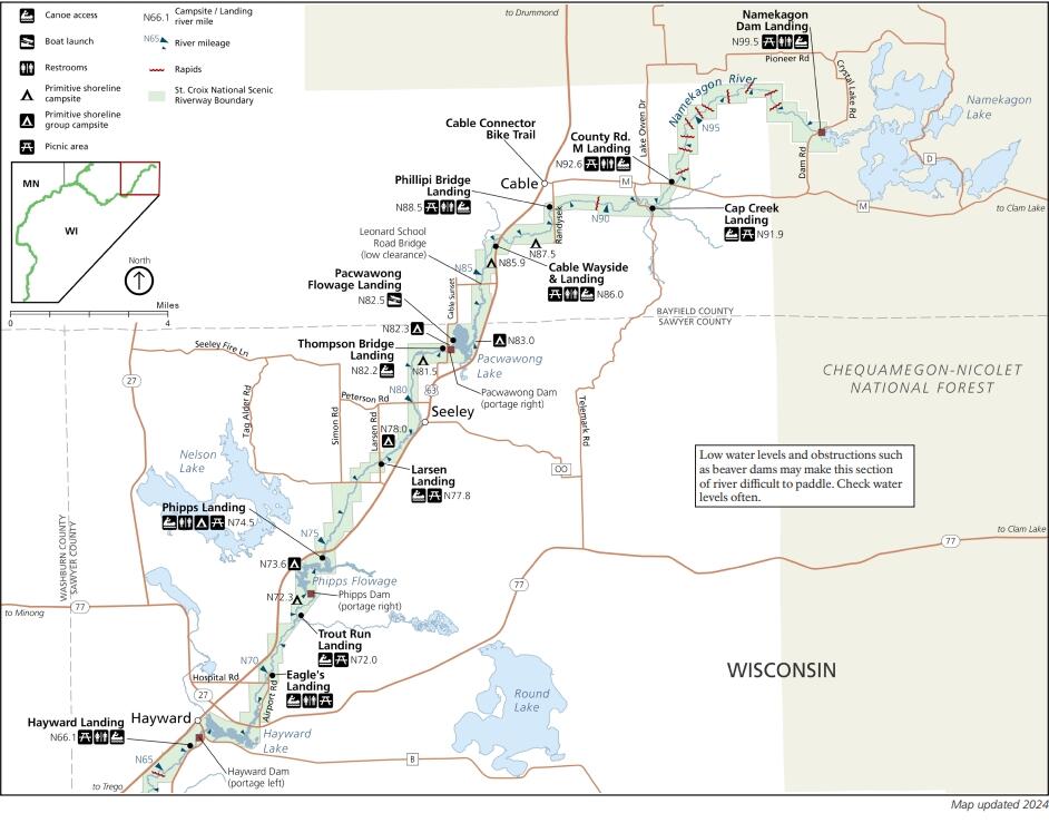
A National Park Service map of a section of the Namekagon River within the St. Croix National Scenic Riverway in Wisconsin.
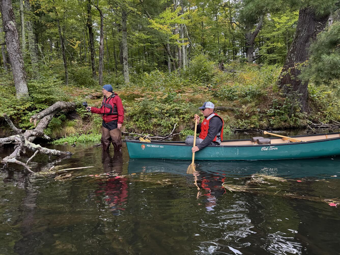
National Park Service Great Lakes Inventory and Monitoring Network (GLKN) biologist Ted Gostomski uses a handheld thermal infrared sensor to identify cold groundwater seeps in the upper Namekagon River near Cable, Wisconsin. Al Kirschbaum, a remote sensing specialist with the NPS-GLKN, documents Gostomski's findings from the canoe.
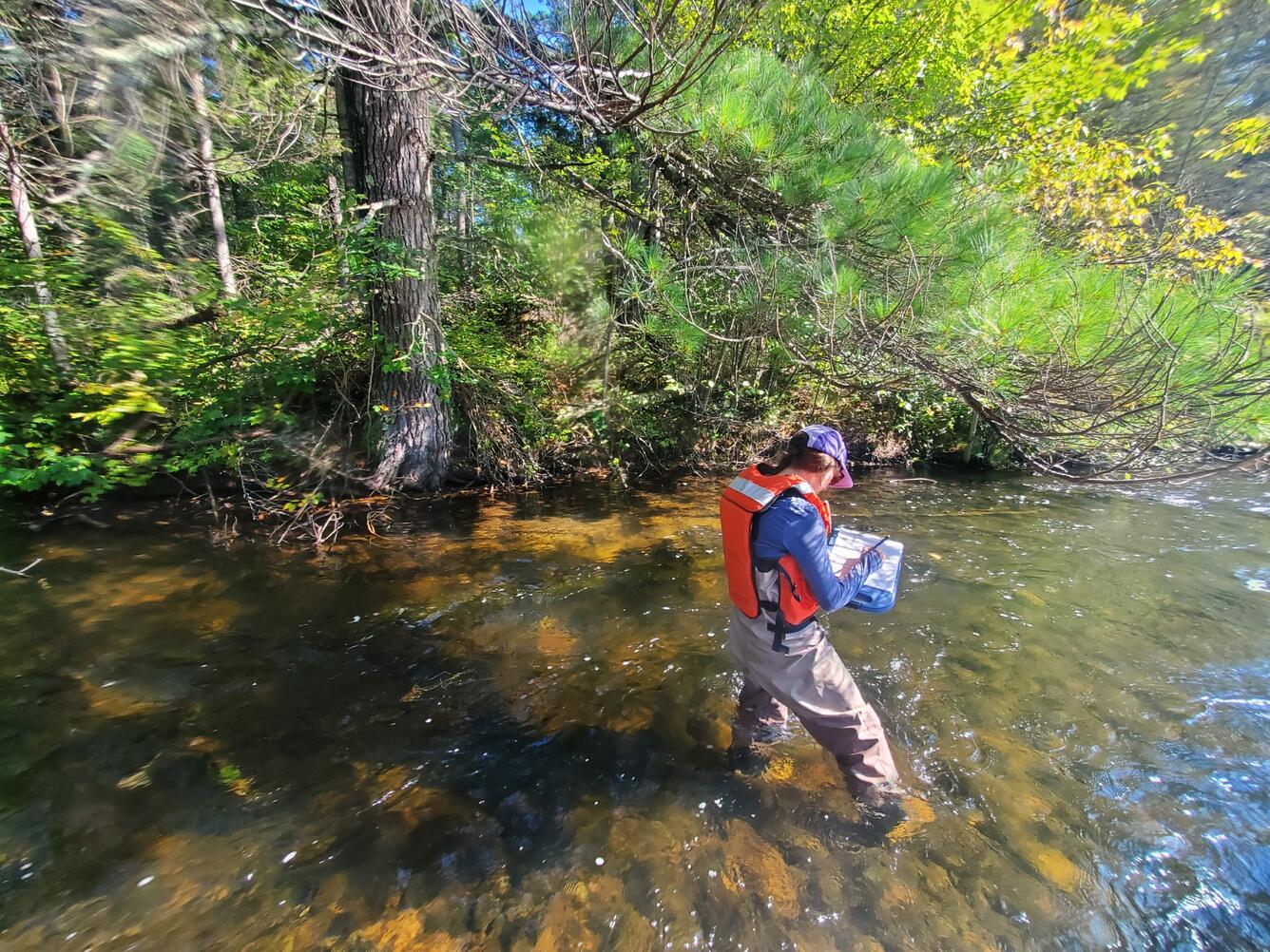
USGS New England Water Science Center physical scientist Shannon Fisher documenting the location of a groundwater seep under a pine tree on the Namekagon River near Cable, Wisconsin.
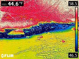
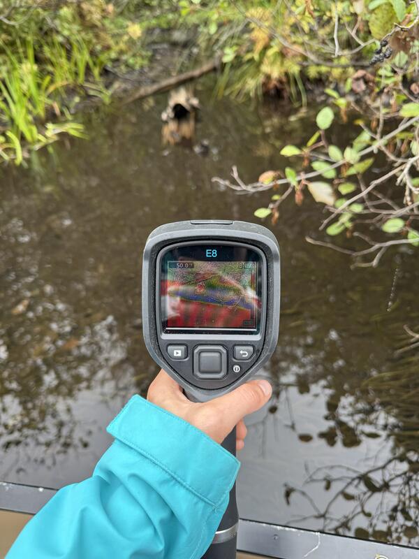
A thermal image taken with a handheld FLIR camera showing approximate water temperature, where warmer temperatures are represented as red and cooler temperatures as blue. This image represents an approximately 20-foot area where cooler groundwater (blue) may be discharging from a bank into a warm stream in early September. The temperature scale is in degrees Fahrenheit.
The U.S. Geological Survey (USGS), in cooperation with the National Park Service (NPS), is using thermal infrared technology to identify cold-water habitat for brook trout and other cold-water species in the upper Namekagon River in Wisconsin. The upper Namekagon River and its tributaries have long served as a stronghold for brook trout and other cold- and cool-water species; however, changing water temperatures have the potential to degrade cold-water habitat in the upper river. In addition, past impacts from logging activities, dams and other development have altered tributary inputs and natural spring flow. Improved information on the location and persistence of cold-water zones can help habitat restoration efforts and potentially brook trout sustainability.
Originating at Lake Namekagon in northern Wisconsin, the Namekagon River flows approximately 101 miles southwest before joining the St. Croix River. Both rivers are protected by the NPS as part of the St. Croix National Scenic Riverway. Brook trout rely on cold-water zones for survival. These cooler areas form where groundwater and smaller tributaries enter the river channel. Cold groundwater zones provide thermally stable, oxygen-rich habitats that are critical for reducing summer thermal stress, supporting successful reproduction, and sustaining trout populations under changing climate and flow conditions. Protecting and restoring these zones is essential for maintaining brook trout populations in the riverway. This project aims to identify the location of groundwater inputs within the Namekagon River channel to determine where cold-water habitat exists and where in-channel rehabilitation efforts by NPS would be most beneficial.
Objectives
The objectives of this study are to inform management strategies that protect and improve stream habitats in the upper Namekagon River by investigating the spatial distribution of cold-water refuges for brook trout and other cold-water species and identifying the locations of potential habitat loss due to river impediments or channel modifications.
Thermal imagery will be collected using a combination of handheld and uncrewed aircraft system (UAS) thermal sensors when the temperature contrast between surface water and groundwater is greatest.
USGS streamgage Namekagon River at Leonards, Wisconsin will be used to monitor surface water temperature and river conditions.
When combined with other limited temperature monitoring efforts on the Namekagon River, this project will support basic temperature modeling throughout the upper reaches to help identify areas most suitable for brook trout habitat. These data will also help inform other habitat restoration efforts meant to benefit multiple life stages of brook trout. Determining how and where the NPS may rehabilitate cold-water habitat will assist managers in determining how to protect native fish communities from threats due to climate change and habitat degradation. In addition to brook trout, this project will provide valuable information on suitable habitat for other species such as native mussels, aquatic invertebrates, amphibians, and reptiles using the riverway.
A National Park Service map of a section of the Namekagon River within the St. Croix National Scenic Riverway in Wisconsin.
National Park Service Great Lakes Inventory and Monitoring Network (GLKN) biologist Ted Gostomski uses a handheld thermal infrared sensor to identify cold groundwater seeps in the upper Namekagon River near Cable, Wisconsin. Al Kirschbaum, a remote sensing specialist with the NPS-GLKN, documents Gostomski's findings from the canoe.
USGS New England Water Science Center physical scientist Shannon Fisher documenting the location of a groundwater seep under a pine tree on the Namekagon River near Cable, Wisconsin.
A thermal image taken with a handheld FLIR camera showing approximate water temperature, where warmer temperatures are represented as red and cooler temperatures as blue. This image represents an approximately 20-foot area where cooler groundwater (blue) may be discharging from a bank into a warm stream in early September. The temperature scale is in degrees Fahrenheit.