
Vermont and Landsat


See Vermont from Space
Use the links below to explore more Landsat resources highlighting Vermont.
Detailed Description
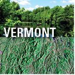
The Green Mountain State of Vermont is known for its vast swaths of deciduous forest, patches of evergreen, and the Green Mountains that run through its center. Its abundance of maple trees helps explain why the word “Vermont” on a bottle of pure maple syrup amounts to a gold star seal of approval, and why 36 percent of the Nation’s maple syrup comes from Vermont. The State’s hiking and ski trails that crisscross its snowy peaks and uncluttered landscapes, meanwhile, explain its popularity as a refuge for recreation.
The land, industries, and people of Vermont are more complex and diverse than its syrup and slopes might suggest. Around 65 percent of Vermont’s agricultural economy is linked to the dairy industry (University of Arkansas System, 2021). Vermont is also a production leader in apples, honey, and Christmas trees, and is one of the largest hay producers in New England.
The waters of Lake Champlain, Lake George, and the Hudson River are also defining features in Vermont, offering transportation corridors, feeding fertile soils, and supporting recreation. Vermont’s water bodies join its snowy peaks as draws for tourism, which generates around $3 billion in annual revenue (Jones, 2018).
Valuable insight into the forests and landscape features of Vermont can be gleaned from the nearly 50-year historical record of Landsat satellite imagery. The archive is accessible at no cost to researchers, land managers, and the public thanks to the open data policy of the USGS National Land Imaging (NLI) Program.
Visit Landsat Benefits, State By State to learn more about how Landsat brings science to your state.
Sources/Usage
Public Domain.