



Mojave Desert Tortoise found in Piute Valley in Clark County, Nevada, in
2005
Images
See our science through the images below.
Filter Total Items: 3543

Mojave Desert Tortoise
Mojave Desert Tortoise found in Piute Valley in Clark County, Nevada, in
2005

Wyoming Big Sagebrush Community Near Winnemucca, Nevada
Wyoming Big Sagebrush Community Near Winnemucca, NevadaMountain big sagebrush - or Artemisia tridentata ssp. vaseyana - is a sub-species of big sagebrush that is found in primarily at higher elevation and colder, drier sites between the Rocky Mountains and the Cascades and Sierra Nevada.
Wyoming Big Sagebrush Community Near Winnemucca, Nevada
Wyoming Big Sagebrush Community Near Winnemucca, NevadaMountain big sagebrush - or Artemisia tridentata ssp. vaseyana - is a sub-species of big sagebrush that is found in primarily at higher elevation and colder, drier sites between the Rocky Mountains and the Cascades and Sierra Nevada.

Bobcat Tracking
A Vermont Unit researcher outfits a captured bobcat with a lightweight GPS collar that will record its daily movements.The collar will provide information on bobcat home range size, habitat use, and movements.
A Vermont Unit researcher outfits a captured bobcat with a lightweight GPS collar that will record its daily movements.The collar will provide information on bobcat home range size, habitat use, and movements.

Bobcat Tracking
A Vermont Unit researcher outfits a captured bobcat with a lightweight GPS collar that will record its daily movements.The collar will provide information on bobcat home range size, habitat use, and movements.
A Vermont Unit researcher outfits a captured bobcat with a lightweight GPS collar that will record its daily movements.The collar will provide information on bobcat home range size, habitat use, and movements.

A Hermit Thrush on the Nest in Arizona
Hermit thrushes are a songbird species that was strongly affected by plant community changes in mountains because of reduced snowpack and cascading ecological effects, according to a USGS Montana Cooperative Wildlife Research Unit study.
Hermit thrushes are a songbird species that was strongly affected by plant community changes in mountains because of reduced snowpack and cascading ecological effects, according to a USGS Montana Cooperative Wildlife Research Unit study.

Acadia National Park
Scenic view of a tree on coastal rocks by shore line.
Scenic view of a tree on coastal rocks by shore line.

Acadia National Park
Coastal view showing rocks and coast line.
Coastal view showing rocks and coast line.

Acadia National Park
Shoreline view with snow-topped mountains in background.
Shoreline view with snow-topped mountains in background.

Acadia National Park
Inlet with sandy shore and coastal rock forms.
Inlet with sandy shore and coastal rock forms.

Acadia National Park
Waves crashing against rocky shoreline.
Waves crashing against rocky shoreline.

Acadia National Park
Shoreline seen through trees with hills in background.
Shoreline seen through trees with hills in background.

Acadia National Park
Waves crashing at sandy inlet surrounded by rocky coast.
Waves crashing at sandy inlet surrounded by rocky coast.

Bass Harbor Light House
Scenic view of light house.
Scenic view of light house.

Acadia National Park
Coastal view showing rocks and coast line.
Coastal view showing rocks and coast line.

Acadia National Park
Scenic view of rock formation and coast line.
Scenic view of rock formation and coast line.

Acadia National Park
Coastal view showing rocks and coast line.
Coastal view showing rocks and coast line.

USGS Scientist Set Mistnets for West Nile Virus Monitoring
USGS Scientist Set Mistnets for West Nile Virus MonitoringUSGS scientists capture and release wild birds while monitoring for West Nile.
USGS Scientist Set Mistnets for West Nile Virus Monitoring
USGS Scientist Set Mistnets for West Nile Virus MonitoringUSGS scientists capture and release wild birds while monitoring for West Nile.
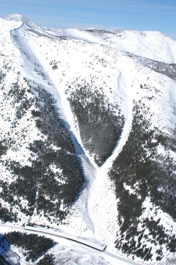
Railway snowshed at bottom of two avalanche paths
A protective snowshed at the confluence of two avalanche paths that start ~3,000' above the shed. This shed is located in southern Glacier National Park and protest part of the railway from avalanches. This is one of many avalanche paths impacting the railway.
A protective snowshed at the confluence of two avalanche paths that start ~3,000' above the shed. This shed is located in southern Glacier National Park and protest part of the railway from avalanches. This is one of many avalanche paths impacting the railway.
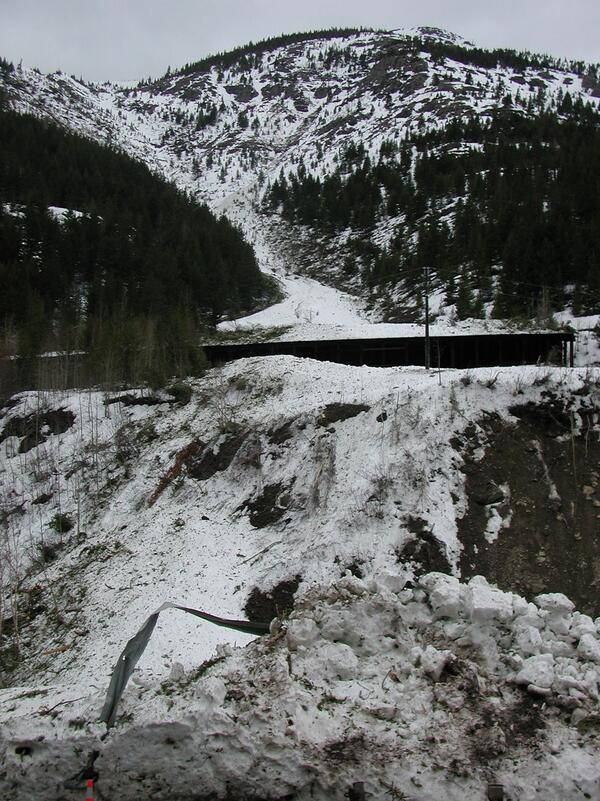
Avalanche debris next to highway and protective railway shed
Avalanche debris next to highway and protective railway shedAvalanche debris of snow, soil, and piece of twisted metal deposited on U.S. Highway 2 near Glacier National Park. The avalanche flowed over and around the protective railway shed in the background.
Avalanche debris next to highway and protective railway shed
Avalanche debris next to highway and protective railway shedAvalanche debris of snow, soil, and piece of twisted metal deposited on U.S. Highway 2 near Glacier National Park. The avalanche flowed over and around the protective railway shed in the background.

Foraminiferans (10 Species)
A photomicrograph depicting the calcium carbonate tests of ten species of marine foraminiferans. Upon death, their tests can form calcareous marine sediments known as foraminiferan ooze.
A photomicrograph depicting the calcium carbonate tests of ten species of marine foraminiferans. Upon death, their tests can form calcareous marine sediments known as foraminiferan ooze.

Diatoms (50 Species)
Photomicrograph depicting the siliceous frustulesof fifty species of diatoms arranged within a circular shape. Diatoms form the base of many marine and aquatic food chains and upon death, their glassy frustules form sediments known as diatomaceous earth.
Photomicrograph depicting the siliceous frustulesof fifty species of diatoms arranged within a circular shape. Diatoms form the base of many marine and aquatic food chains and upon death, their glassy frustules form sediments known as diatomaceous earth.