
Early detection and rapid response are critical to controlling the spread of New World Screwworm, a blowfly pest that has re-emerged in the U.S.
Multimedia
Below are multimedia (photos, graphics, audio, and video) associated with the Ecosystems Mission Area.
Be certain to check out Outstanding in the Field, an original podcast series that tells stories about our science, our adventures, and our efforts to better understand fish and wildlife and the ecosystems that support them.
Images
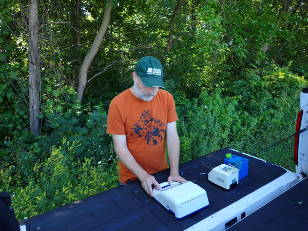
New World Screwworm Rapid DNA Field Testing Tool
Early detection and rapid response are critical to controlling the spread of New World Screwworm, a blowfly pest that has re-emerged in the U.S.
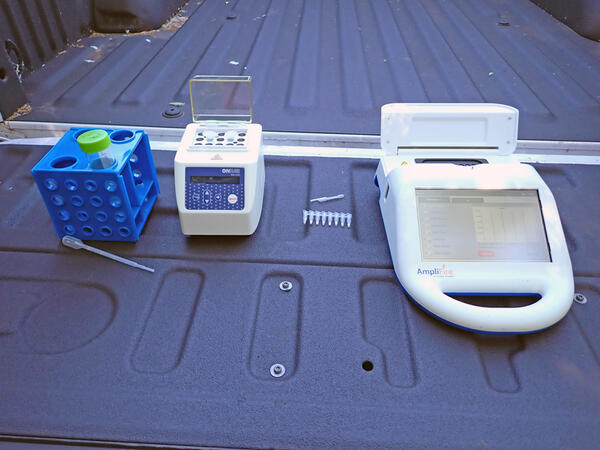
Point-of-Use Rapid Detection for New World Screwworm
Point-of-Use Rapid Detection for New World ScrewwormEarly detection and rapid response are critical to controlling the spread of New World Screwworm, a blowfly pest that has re-emerged in the U.S.
Point-of-Use Rapid Detection for New World Screwworm
Point-of-Use Rapid Detection for New World ScrewwormEarly detection and rapid response are critical to controlling the spread of New World Screwworm, a blowfly pest that has re-emerged in the U.S.
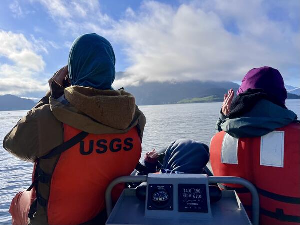
Biologists conducting marine bird and mammal surveys in Kachemak Bay, Alaska
Biologists conducting marine bird and mammal surveys in Kachemak Bay, AlaskaTwo USGS biologists conducting marine bird and mammal surveys as part of the Exxon Valdez Oil Spill (EVOS) Long Term Monitoring program. The surveys provide estimates of the species composition, relative abundance, and distribution of all marine birds and mammals within the nearshore zone.
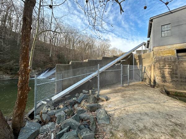
Eden Mill Eel Ladder
An eel ladder constructed along the Eden Mill Damn to help American eels make their way up and over the water.
An eel ladder constructed along the Eden Mill Damn to help American eels make their way up and over the water.
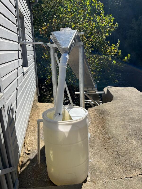
Eden Mill Eel Ladder Barrel
The barrel that the eels go into after they make it up the eel ladder at Eden Mill.
The barrel that the eels go into after they make it up the eel ladder at Eden Mill.
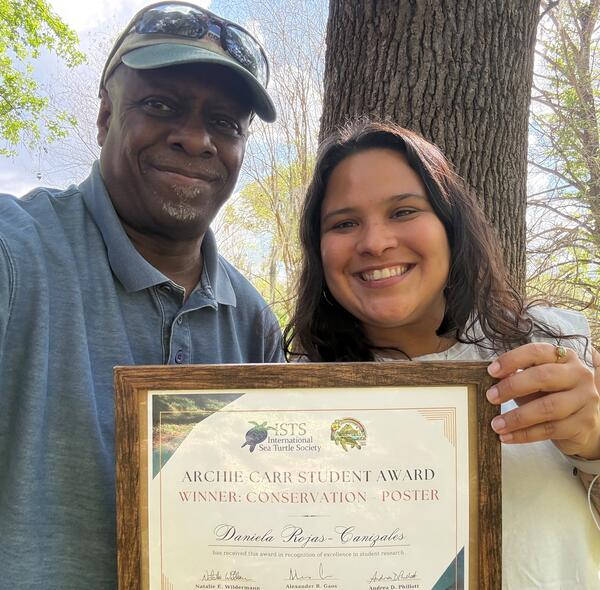
Daniela Rojas-Cañizales holds her award with Ray Carthy, Florida Cooperative Fish and Wildlife Research Unit
Daniela Rojas-Cañizales holds her award with Ray Carthy, Florida Cooperative Fish and Wildlife Research UnitDaniela Rojas-Cañizales, graduate student at the Florida Cooperative Fish and Wildlife Research Unit, takes First Place award-winning poster, “Beyond the shell: Exploring the dimensions of sea turtle take in Bocas del Toro, Panama, Conservation Posters at the 44th International Sea Turtle Symposium in Kona, Hawaii.
Videos

Saline Lake Ecosystems IWAA Spring Seminar: Project Updates and 2026 Field Season Plans
Saline Lake Ecosystems IWAA Spring Seminar: Project Updates and 2026 Field Season PlansThis video presents the Spring 2026 Saline Lake Ecosystems Integrated Water Availability Assessment Spring Seminar by the U.S. Geological Survey (USGS). Narrated by Lisa Hoaks, the seminar provides project updates, summer 2026 field season plans, and recently published products.

RAD and Adaptive Management Webinar
RAD and Adaptive Management Webinar, part of the NCASC Webinar Series: Incorporating the RAD (Resist-Accept-Direct) Framework into Resource Management Planning.
RAD and Adaptive Management Webinar, part of the NCASC Webinar Series: Incorporating the RAD (Resist-Accept-Direct) Framework into Resource Management Planning.

Big Game and Chronic Wasting Disease
USGS science on chronic wasting disease (CWD) tackles multiple facets of this complex management challenge.
USGS science on chronic wasting disease (CWD) tackles multiple facets of this complex management challenge.

Rusting Rivers B-Roll: Igning River, Alaska
This is B-roll video of the Igning River, Gates of the Arctic National Park and Preserve, Alaska from August 26, 2024.
This is B-roll video of the Igning River, Gates of the Arctic National Park and Preserve, Alaska from August 26, 2024.

Rusting Rivers B-Roll: Kugururok River, Alaska
This is B-roll video of the Kugururok River, Noatak National Preserve, Alaska from August 30, 2025.
This is B-roll video of the Kugururok River, Noatak National Preserve, Alaska from August 30, 2025.

Rusting Rivers: Heavy Metals and Visible Color Changes
Rusting Rivers: Heavy Metals and Visible Color ChangesRusting rivers are increasingly common in the Brooks Range of northern Alaska. The orange stream color reflects oxidized iron (hence the appearance of rusting), but orange color also indicates elevated heavy metal concentrations and impaired water quality.
Audio

USGS Outstanding in the Field, Episode 11, Designing Accessible Research for Rural Communities
USGS Outstanding in the Field, Episode 11, Designing Accessible Research for Rural CommunitiesThis is a special edition of Outstanding in the Field, the U.S. Geological Survey’s podcast series produced by the Ecosystems Mission Area. In this episode we highlight stories from the Alaska Voices podcast, a partnership between the U.S. Geological Survey’s Alaska Climate Adaptation Science Center and the University of Alaska Fairbanks.

USGS Outstanding in the Field, Episode 10, Bats
Welcome to the USGS Ecosystems Mission Area Outstanding in the Field podcast series that tells stories about our science, our adventures, and our efforts to better understand fish and wildlife and the ecosystems that support them.
Welcome to the USGS Ecosystems Mission Area Outstanding in the Field podcast series that tells stories about our science, our adventures, and our efforts to better understand fish and wildlife and the ecosystems that support them.

USGS Outstanding in the Field: Biocrusts (Ep. 9)
Welcome to another episode of Outstanding in the Field, the U.S. Geological Survey’s podcast series produced by the Ecosystems Mission Area. We highlight our fun and fascinating fieldwork studying ecosystems across the country. Today we’ll be discussing tiny communities that are found on the surface of the soil in the harsh environments of cold and hot deserts.
Welcome to another episode of Outstanding in the Field, the U.S. Geological Survey’s podcast series produced by the Ecosystems Mission Area. We highlight our fun and fascinating fieldwork studying ecosystems across the country. Today we’ll be discussing tiny communities that are found on the surface of the soil in the harsh environments of cold and hot deserts.

USGS Outstanding in the Field, Episode 8, Braving thin ice
USGS Outstanding in the Field, Episode 8, Braving thin iceThis is the first in a special edition of Outstanding in the Field, the U.S. Geological Survey’s podcast series produced by the Ecosystems Mission Area. In this series we will be highlighting stories from the Alaska Voices podcast, a partnership between the U.S. Geological Survey’s Alaska Climate Adaptation Science Center and the University of Alaska Fairbanks.

Outstanding in the Field Episode 7 - Science in the Swamp
Outstanding in the Field Episode 7 - Science in the SwampIn this episode of Outstanding in the Field, we take you to the swamps and coastal wetlands of Louisiana, the land of bayous and beignets and a state with one of the most dynamic coastlines in the United States. The wetlands that make up the Louisiana coast are vast and help protect important cultural and natural resources.

USGS Outstanding in the Field - Not Enough Beaches in Grand Canyon?
USGS Outstanding in the Field - Not Enough Beaches in Grand Canyon?In this episode of Outstanding in the Field, we are talking about beaches in a place that most people probably would not think of—the Grand Canyon.
USGS Outstanding in the Field - Not Enough Beaches in Grand Canyon?
USGS Outstanding in the Field - Not Enough Beaches in Grand Canyon?In this episode of Outstanding in the Field, we are talking about beaches in a place that most people probably would not think of—the Grand Canyon.