
A Research Retrospective: Offshore Mapping of the San Andreas
Study of New Offshore Fault Mapping Related to the 1906 San Francisco Earthquake: In 2019, for the first time ever, scientists comprehensively mapped a previously overlooked offshore section of the San Andreas Fault system which may provide insight on how the fault could rupture in the future.
In the early morning hours of April 18th, 1906, an alarming shake and rumble underfoot along the coastal areas of northern California gave way to a living nightmare of unprecedented devastation. At 5:12am, what would be considered one of the most devastating earthquake events in U.S. history wreaked unimaginable havoc on the burgeoning city of San Francisco.
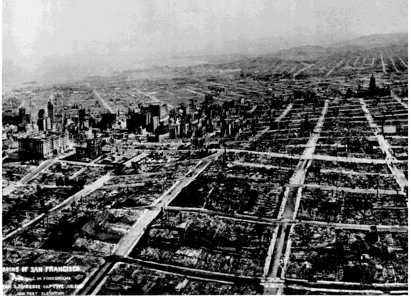
This California earthquake ranks as one of the most well-known and impactful of all time. Today, its importance stems not only from the sheer magnitude of the quake (7.7-7.9), but also from the wealth of scientific knowledge derived from studying the event. Rupturing the northernmost 477 kilometers (296 miles) of the San Andreas fault from northwest of San Juan Bautista to the triple junction at Cape Mendocino, the earthquake confounded geologists with its large, horizontal movement and the massive length of the fault rupture.

The full scope of the fault and how much it had shifted would not be fully appreciated until the advent of plate tectonics more than half a century later; in fact, study of this 1906 event ushered in the dawn of a seismic scientific revolution and the creation of a preeminent report on such events, the Lawson Report of 1908.
In early 2019, Samuel Johnson of the U.S. Geological Survey (USGS) and Jeffrey Beeson of Fugro USA Marine Inc., for the first time mapped a 35-kilometer-long offshore section of the fault between Tomales Point and Fort Ross, California.

Using high-resolution surface and subsurface mapping data collected with high-tech acoustic instruments, Johnson and Beeson created highly detailed maps of the area, which resulted in some significant new findings: (1) two large zones (each ~ 5 km2) of sediment failure on the sloping seafloor offshore of the Russian River, lobes that appear to have formed when the intense shaking from the 1906 earthquake resulted in sand liquefaction, were documented; (2) the strike of the fault on both a local and regional scale was found to impact both the offshore and the adjacent onshore landscapes, including basins, uplifted marine terraces, beaches, and coastal sand dunes; and (3) two active strands of the fault were mapped within the northern part of Bodega Bay, each of which has moved tens of meters within the past 10,000 years, which is an incredibly far distance in terms of geologic movement.
The Seismological Society of America (SSA) published this new report in April of 2019. In SSA’s press release of the report, Dr. Johnson offered his perspective on the project: “It’s a major geoscience oversight that these northern areas have not been studied before,” said Johnson. “But we have been waiting for the technology to advance, allowing us to look at these areas in high resolution.”

For the offshore work, geologists use acoustic mapping tools deployed from a slow-moving boat on a tight grid for complete water depth and seafloor mapping coverage. Comparable topographic mapping data on land are collected from an airplane using LIDAR (a pulsed laser instrument), producing data that allow geologists to examine and analyze a fault zone. However, it is virtually impossible to collect on-land subsurface acoustic data that is comparable to offshore data quality and density. Fault mapping in the oceans thus produces different but highly complementary data compared with on-land fault mapping.

As the technology to chart underwater faults progressed, mapping this poorly known section of the northern San Andreas Fault became possible. The maps revealed signs of the 1906 San Francisco earthquake, which may hold clues as to how the fault might rupture again in the future.
“Normally if you were studying a fault zone on land and found a prominent fault strand, you would probably assume that was the strand that has most recently ruptured,” Dr. Johnson explained in April of 2019. “Because we found two strands here, it’s a cautionary tale for earthquake geologists to comprehensively map fault zones. You may only capture part of the earthquake history or slip rate along a fault if you only know about one strand in a multi-strand zone.”
Without a comprehensive picture of fault zones, critical information about the characteristics of active faults and how they interact with each other could be missed – information that ultimately helps predict future quakes and protect people from their impacts. Looking back at the study more than a year later, Dr. Johnson imparted just how important having the “full picture” of fault dynamics is to communities along fault zones:
“These data directly contribute to federal and state earthquake hazard assessments, most notably the USGS National Seismic Hazard Maps and the Uniform California Earthquake Rupture Forecast. California is ‘earthquake country,’ and the safety and viability of the built relies on accurate earthquake hazard assessments. Hazard assessments have enormous economic impact as they are used in seismic provisions for building codes, insurance rate structures, risk assessments, land-use planning, and other public policy. This section of the San Andreas fault ruptured in the 1906 M~7.9 San Francisco earthquake, with similar events thought to have a recurrence interval of about 250 years. It is important to understand recent earthquake effects in order to prepare for the inevitable next San Andreas fault earthquake.”

Dr. Johnson retired from the USGS in June 2019, but remains an emeritus research geologist, still working out of the same lab at the USGS Pacific Coastal and Marine Science Center (PCMSC) in Santa Cruz, California. In his emeritus position, he remains actively engaged in work on the San Andreas and other fault networks in the region.
“Staff of the USGS PCMSC Geohazards project are now conducting similar geophysical mapping of the Cascadia subduction zone offshore of the U.S. Pacific Northwest,” he said during an online interview recently. “Additionally, comparable geophysical mapping work is now also occurring offshore in central California.” It is an area of research that continues to provide ample opportunity to learn how earthquakes behave and how they can impact communities.
“I continue to be fascinated by how the trend of the [San Andreas] fault has so much control on adjacent landscape geomorphology at both the local and regional scale. In fact, earlier this year, we published a study on how active faults, combined with sea-level rise and sediment supply, control offshore sediment distribution along a ~800-km-long section of the California coast. Documentation and synthesis of the many ways that faults control the landscape, including offshore sediment distribution, is fascinating.”