
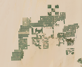
In a remote part of the Sahara Desert in Egypt, center pivot irrigation fields fill the landscape. Thanks to the Landsat archive, we can see how dramatically this area has changed over the last 35 years. But until the growth in irrigation, this part of the world hadn't changed much from a satellite's perspective.
By Earth Resources Observation and Science (EROS) Center
June 17, 2020
The Landsat satellites were designed to detect landscape changes over time. However, sometimes what Landsat needs to see on the Earth’s surface is no change at all.
Picking Calibration Sites
A team of engineers at the USGS Earth Resources Observation and Science (EROS) Center uses radiometric test sites around the world to make sure Landsat imagery is consistent and accurate. These calibration test sites are regions on the Earth that remain stable over the long term. They do not change year to year or season to season. That usually means deserts or dry lakebeds.
“They have to be really dry places with no human intervention,” said Dennis Helder, Senior Calibration Advisor at EROS and Distinguished Professor Emeritus at South Dakota State University (SDSU).
The engineers use the term pseudo-invariant to describe these sites. They are not completely invariant because no site can be perfectly stable over time and must vary to some degree. So they refer to the sites as PICS, for Pseudo-Invariant Calibration Sites.
“Most of our best PICS are in the Sahara,” Helder said. “These sites exhibit an arid surface covered with large homogeneous seas of sand, low annual rainfall, and a lack of vegetation.”
“As long as these sites don’t change, they’re terrific for calibration,” he added.
The idea of studying these test sites is actually pretty basic. Engineers look at a spot of land that is not expected to change over time. The reflectance at different wavelengths of light in the Landsat data should stay stable. When they see changes in these reflectance values, it may mean the sensor’s response has shifted.
The Case of Egypt-2
Media
Sources/Usage: Public Domain. View Media Details
One of the best test sites, named Egypt-2, was steadily reliable until around the late 1990s, when the team began noticing some decay in the reflectance values in the Landsat 5 data. The engineers needed to look into why the sensor readings seemed to be trending downward. Could it mean a shift in the sensor?
All it took was a visual look at the scene, a vast expanse of Sahara Desert in southern Egypt, to see what was causing the changes in sensor readings. Center pivot irrigation fields had suddenly appeared. There had been only sand there just a few years before.
Precipitation is extremely rare here, so how do they get water for all these crops?
The region, called Sharq El Owainat, sits atop the Nubian Sandstone Aquifer System. Groundwater from the aquifer is pumped through wells to the surface and spread to the field via center-pivot irrigation sprinklers. The region now produces about a third of Egypt’s wheat crop, which is exported by way of the Sharq El Owainat airport, visible to the right of the fields in the images.
With all of that land use change now happening in the region, Egypt-2 could not continue as a test site.
It was a valuable calibration site, but Helder emphasizes that there are others. “We figured growing food was more important than one more calibration site,” he said. Besides, the loss of this site sparked a new idea in the use of calibration sites in the Sahara.
What if the entire Sahara Desert could be a test site?
Continental-scale Calibration
When he was a graduate student at SDSU, Mahesh Shrestha, who now works on the calibration team at EROS, explored this idea. He considered one of the other stable calibration sites in the Sahara, named Libya-4. It’s a reliable site with no human intervention to change the landscape. The problem is, as with all test sites, Landsat visits the site only every 16 days.
“That temporal revisit time limits us to wait for 2-3 years to determine the stability of the sensor using that site,” Shrestha said.
For his PhD dissertation, Shrestha proposed, “Let’s study the spectral characteristics of each and every stable pixel in the Sahara Desert.”
If that sounds like it would be a huge number of pixels, it is. Billions of them.
As Shrestha said, it was a good idea, but “the idea is not enough. You have to have tools to apply this idea. Google Earth Engine really helped us process those huge continental-scale data.”
Media

Sources/Usage: Public Domain. View Media Details
Mahesh’s advisor at SDSU, Larry Leigh, took advantage of the processing power of Google Earth Engine for initial processing of Landsat 8 imagery. Without that, the computational time necessary for the task would have taken months. Instead, it only took days. Then Shrestha’s algorithm could be implemented on a local server to search for stable pixels. “Then we could implement the idea and know whether our thinking is right or wrong,” Shrestha said.
“If I find a pixel whose spectral property is similar to Libya-4,” he said, “then I can say that the observation that I made from a different location is the same as though it were from Libya-4. It’s essentially the same pixel.”
How many stable pixels in the Sahara are similar to the spectral properties of Libya-4?
As it happens, there are millions of those pixels, and they extend from east to west across the Sahara. Observations of those pixels are available from enough different dates that they can now have a daily calibration point instead of one every 16 days. Shrestha said, “That will help to reduce uncertainty in the satellite calibration.”
This idea is still in the research phase, and they are working to understand the approach better. But so far, research results are very promising.
Landsat’s Accuracy
So while the Egypt-2 test site has faded, new ideas are blooming to make the Landsat data even more accurate.
Landsat’s accuracy is key to other systems as well. Satellite sensors launched by other countries, cubesats launched by private companies, and sensors on NASA Earth-observing satellites benefit from the accurate Landsat calibration. Helder emphasizes that test sites are key to “providing insurance that we are calibrated well and agree with each other.”
Calibration work may seem quite esoteric, but it makes the science application work possible. The work that really solves problems couldn’t be done without the accuracy of the data. Helder claims, “Landsat images are simply pretty pictures—until we calibrate them; then they become accurate datasets.”
Related

Watering the Sahara
In a remote part of the Sahara Desert in Egypt, center pivot irrigation fields fill the landscape. Thanks to the Landsat archive, we can see how dramatically this area has changed over the last 35 years. But until the growth in irrigation, this part of the world hadn't changed much from a satellite's perspective.
Related
Watering the Sahara
In a remote part of the Sahara Desert in Egypt, center pivot irrigation fields fill the landscape. Thanks to the Landsat archive, we can see how dramatically this area has changed over the last 35 years. But until the growth in irrigation, this part of the world hadn't changed much from a satellite's perspective.
In a remote part of the Sahara Desert in Egypt, center pivot irrigation fields fill the landscape. Thanks to the Landsat archive, we can see how dramatically this area has changed over the last 35 years. But until the growth in irrigation, this part of the world hadn't changed much from a satellite's perspective.