
Celebrate Oceans Month – USGS Science on the Seas
USGS Science on the Seas
Our Earth is indeed a watery planet – nearly two-thirds of its surface is covered by water. And all but 3% of that water covers land submerged under the oceans. Our seas are the source of living and non-living resources that we rely on for food, recreation, protection from storms, energy and minerals, and so much more.
We play on our coasts and in our oceans, harvest seafood from them, buy and sell products transported by ocean-going ships, and depend on oceans for the production of energy, minerals, and living resources. It is no wonder, then, that our planet’s seas are also a centerpiece of human myth and literature, art and songs, and history.

It Starts with Science!
Our scientists conduct research in coral reefs and on ice floes and glaciers, in the deepest ocean waters and in the shallowest, in breathtakingly blue subtropical water or in mucky coastal marshes. They can be found in some of our most storied places: Puget Sound, San Francisco Bay, the Great Lakes, Chesapeake Bay, the Everglades, and the Pacific Islands.
The data and knowledge that the U.S. Geological Survey coastal, ocean, hazard and deep-sea researchers deliver every day underpin the choices that citizens, managers and policy makers make about the nation’s marine resources. And it also helps them mitigate against hazards that oceans present such as hurricanes, flooding, tsunamis and earthquakes.
USGS expertise includes characterizing and mapping the seafloor, identifying living and non-living ocean and coastal resources, hazards, habitats, and the plants and animals that live in or rely on the ocean. We also assess how oceans and coasts have changed and could change in the future. Such research allows for a big-picture perspective on the interconnectivity among our oceans and coasts, our people and our environment.
Below are a few examples of our many ocean studies. To see more, check out our USGS Facebook and Instagram pages where we are posting about our ocean research throughout the month.
Dive Right In
America is increasingly dependent on ocean resources not only for food, but also for energy, raw materials for construction, and minerals vital to emerging communication and information technologies. Resources of high interest and value are gas hydrates, renewable offshore wind energy, tides and currents, deposits of rare earth elements, and sand and gravel deposits for construction and beach nourishment. The USGS conducts research studies focused on geologic mapping, sampling and understanding of mineral and energy resources and studies of their geologic setting and processes to inform renewable energy development offshore.
In one such study, USGS and Bureau of Ocean Energy Management scientists headed out to sea in April to continue exploring deep-sea ecosystems off the U.S. Mid- and South Atlantic coasts. This is the fourth cruise for the DEEP Sea Exploration to Advance Research on Coral/Canyon/Cold seep Habitat (DEEP SEARCH) project, a collaborative partnership among the USGS, BOEM, and the National Oceanic and Atmospheric Administration.
Sailing aboard NOAA Ship Ronald H. Brown, the DEEP SEARCH team spent three weeks visiting an extensive reef system between Virginia and Georgia to collect baseline information on coral, canyon and cold seep habitats to help inform management activities in the region. These deep-sea ecosystems play an integral role in carbon and energy cycling and provide food for animals higher up in the food chain, including species of commercial and recreational value. Despite its importance, very little is known about the deep sea — in fact, scientists estimate that just about 5% of the deep seafloor has been explored.
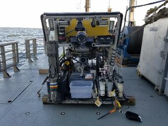
The science team used a remotely operated vehicle to collect data and biological and geological samples. The information collected during the four DEEP SEARCH expeditions will ultimately help characterize the region’s largely unexplored natural resources.
Learn more about DEEP SEARCH 2019—You can check out mission logs, meet the explorers, view image and video galleries, find educator information and media resources, and more. Visit here for more information on this and other USGS deep-sea coral expeditions. To learn more about BOEM’s research, visit here.
The Cascadia Subduction Zone: Earthquakes, Submarine Landslides, and Tsunamis, Oh My!
In the U.S. Pacific Northwest, subduction-related tectonic activity creates substantial hazard potential for earthquakes, submarine landslides, and tsunamis. This geologically active environment also aids in the circulation of fluids through the seafloor, supporting unique and little-known biological communities and controlling the formation and distribution of marine mineral resources of national interest. As part of the joint USGS, BOEM, and NOAA collaboration on Expanding Pacific Research and Exploration of Submerged Systems or EXPRESS, the USGS will participate in marine mapping and geophysical surveys of the geologic structures along the U.S. Cascadia margin to improve our risk assessments related to earthquakes, submarine landslides and tsunamis.
USGS researchers are also conducting related onshore studies of faults and paleo-seismologic records of earthquake recurrence; analyzing offshore gas seeps; and developing long-term strategies to better assess regional risks associated with the Cascadia subduction zone. A related research cruise in partnership with the Schmidt Ocean Institute and the German Marine Research Consortium is currently at sea. You can follow the researchers and even watch them explore the deep sea in real time.
MATRIX: Exploring Gas Hydrate Systems
USGS scientists and partners recently completed investigations of marine gas hydrate systems along the U.S. Mid-Atlantic margin to better understand the associated deep-marine biological communities. Gas hydrates are ice-like combinations of methane gas and water that occur naturally in marine sediments and permafrost areas. Gas hydrates are a significant potential energy resource and influence the stability of the seafloor.
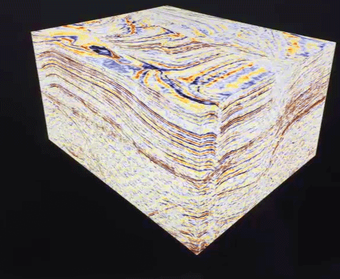
The USGS-led Mid-Atlantic Resource Imaging Experiment, which was jointly sponsored with the Methane Hydrates R&D Program at the Department of Energy and the BOEM, acquired more than 1,240 miles (2,000 kilometers) of marine seismic data that image gas hydrate features and other geologic structures below the seafloor in deep-water areas offshore from New Jersey to North Carolina.
The MATRIX geophysical data not only help us identify deep-water gas-hydrate deposits, but also better understand deep-marine biological communities and the energy-resource potential of marine hydrates as well as their interaction with the environment and with geohazards, such as submarine landslides. MATRIX produced data that will be used for decades to come by the USGS, other agencies, and the academic community.

Coastal Change and the Value of Coral Reefs
Coastal change poses potential risk to coastal communities across the nation. Powerful storms generate surge, waves and currents that can move large amounts of sediment; can destroy roads, buildings, and other critical infrastructure; and can alter natural habitats. The USGS performs a range of studies that document, assess, and model coastal change, risk, and vulnerability. These studies include historical shoreline change and the geologic structure and history of coastal regions, sediment supply and transport, sea-level rise, and how extreme storm events affect rates and impacts of coastal change.
A recent USGS study, partly funded by the U.S. Department of the Interior’s Office of Insular Affairs, demonstrates the benefits coral reefs provide to coastal communities in the United States and its trust territories. For example, USGS scientists found that coral reefs provide a flood protection barrier for more than 18,000 coastal citizens and for \$1.8 billion worth of coastal infrastructure in the U.S. annually. The information from this research will help managers take effective actions to reduce the risk to, and increase the resiliency of, U.S. mainland and insular area coastal communities to flooding and other hazards.
Hurricanes
The 2019 Atlantic hurricane season has started, and the USGS is prepared to provide science that can help guide efforts to protect lives and property if a major storm makes landfall this season. Tropical storms, hurricanes and other large coastal storms can impact coastal and inland communities and ecosystems with high winds, storm surge, erosion and flooding. These forces can destroy buildings, roads and bridges and reshape the nation’s coastline.
When a major storm threatens to make landfall in the United States or its territories, the USGS provides comprehensive scientific capabilities and information that decision makers, emergency responders and communities can use to help them prepare for, cope during, and recover from a storm. This includes the USGS’s ability to forecast coastal change; track storm surge, river and stream levels and flow; measure coastal and inland flooding across entire regions; capture high-resolution ground elevation and topographic data; and create detailed maps used by disaster teams responding in the aftermath of storms.

Coastal Change: Atlantic and Gulf Coasts
The USGS performs a range of studies that document, assess and model coastal change, risk and vulnerability. For example, since 1995 the USGS has collected more than 140,000 aerial photographs of the Atlantic and Gulf coasts after 24 hurricanes and other extreme storms. The USGS has also created a national map that shows past and present trends and rates through our National Assessment of Shoreline Change Project.
You can help too! A crowdsourcing application called iCoast – Did the Coast Change? was launched by the USGS to show coastal changes from extreme storms. Citizens can provide input and help scientists by comparing aerial photographs taken before and after storms.
Furthermore, the USGS created an online tool that allows anyone to interactively see past, present and future hazards and changes along the coasts. This tool—the USGS Coastal Change Hazards Portal—is an interactive mapping product with layers of information allowing you to explore your local area or the entire nation. How vulnerable is your favorite beach if a hurricane like Katrina, Ike or Sandy paid a visit? What did your beach look like 50, 100 or 150 years ago? What might it look like in the future? Check out the Portal and find out!
Improving White Sturgeon Recruitment in the Columbia River Basin
White sturgeon, which live in the big river systems along the west coast, are the largest freshwater fish in North America. This primitive-looking fish—with bony plates running along its back, a long snout, and whisker-like barbels— can reach lengths of 20 feet and live more than 100 years. Although some white sturgeon populations migrate between the ocean and fresh water, others are landlocked and do not migrate at all. White sturgeon are an important commercial and recreational fish and are culturally important to Native American tribes in the Pacific Northwest.
Yet overharvest and vast habitat changes have caused white sturgeon populations to decline throughout their habitat. Dams restrict the movement of white sturgeon in many rivers and have altered the habitat they need for spawning and rearing their young. In the Columbia River Basin, the ability of white sturgeon to survive their first year varies greatly, with some areas where few fish survive and others where some survive year after year.
USGS scientists from the Western Fisheries Research Center and the Idaho Water Science Center teamed up and discovered factors that helped increase the survival of these ancient fishes, including increased springtime water flows and more gravel or cobble for egg laying. This information is useful to biologists, water managers and agencies who help maintain or restore white sturgeon spawning habitat throughout the Columbia River Basin.
