
This video showcases the latest polar bear point-of-view footage to date along with an interview of the research scientist who is responsible for the project. Released in conjunction with a new scientific study led by the USGS.
Ryan McClymont (Former Employee)
Science and Products

Polar Bears Film Their Own Sea Ice World
This video showcases the latest polar bear point-of-view footage to date along with an interview of the research scientist who is responsible for the project. Released in conjunction with a new scientific study led by the USGS.
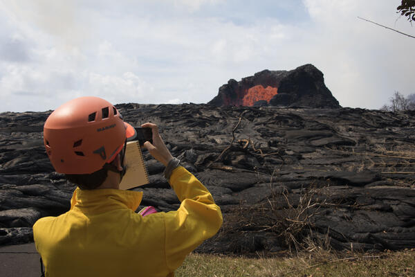
A volcanologist observes a lava fountain during the 2018 Kilauea eruption
A volcanologist observes a lava fountain during the 2018 Kilauea eruptionU.S. Geological Survey Volcanologist Matthew Patrick photographs and observes a lava fountain in the Leilani Estates near Hilo, Hawai`i on Sunday, May 27, 2018.

Kīlauea Volcano – USGS 24 Hour Watch: Monitoring Lava Flow
Kīlauea Volcano – USGS 24 Hour Watch: Monitoring Lava FlowScientists from the U.S. Geological Survey’s Hawaiian Volcano Observatory are part of a 24 hour watch during the ongoing eruption on the lower east rift zone of the Kīlauea Volcano. Working in shifts they keep an eye on where the lava activity is and where it might move to.

Return of the Yellowstone Grizzly Bear
Yellowstone grizzly bears inhabit federal, state, tribal, and private lands, and long-term research requires careful coordination across governmental levels.
Yellowstone grizzly bears inhabit federal, state, tribal, and private lands, and long-term research requires careful coordination across governmental levels.

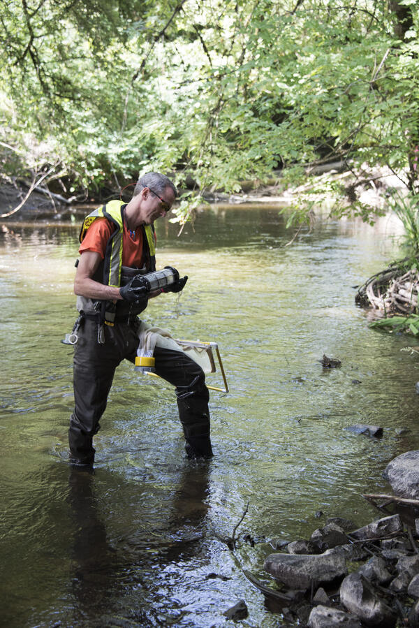
Using a Continuous Flow Centrifuge to Collect Suspended Sediment
Using a Continuous Flow Centrifuge to Collect Suspended SedimentKathy Conn, a U.S. Geological Survey Water Quality Specialist, demonstrates a new USGS field method using a continuous flow centrifuge to collect suspended sediment from large volumes of water in the Duwamish River near Seattle Washington.

Resilient Voices: Adaptation Across Worldviews
The Department of the Interior Pacific Islands Climate Science Center and the University of Hawaiʻi at Hilo developed and hosted a Climate Change Boot Camp that showcased collaborative research efforts within UH Hilo’s Tropical Conservation Biology and Environmental Science graduate program that are driven by local natural resource managers across Hawaiʻi Islan
The Department of the Interior Pacific Islands Climate Science Center and the University of Hawaiʻi at Hilo developed and hosted a Climate Change Boot Camp that showcased collaborative research efforts within UH Hilo’s Tropical Conservation Biology and Environmental Science graduate program that are driven by local natural resource managers across Hawaiʻi Islan

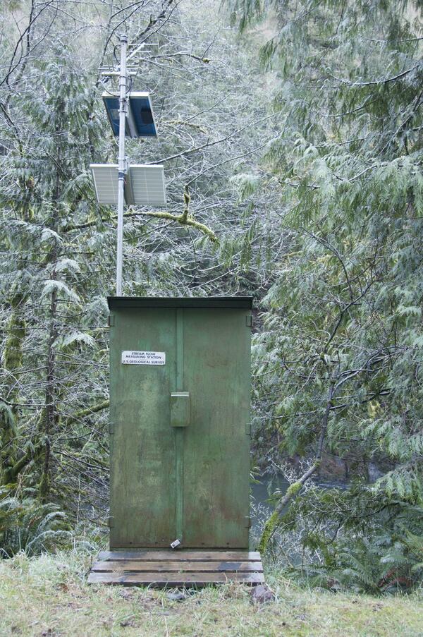
USGS streamgage on the Trask River
Trask River stage, discharge, and water-quality data are collected and used together to help monitor the current health of the river. Instream equipment is stored in protective housing to protect it from the elements. Data from the river are sent to equipment in the gage house, where it is stored then transmitted to USGS servers.
Trask River stage, discharge, and water-quality data are collected and used together to help monitor the current health of the river. Instream equipment is stored in protective housing to protect it from the elements. Data from the river are sent to equipment in the gage house, where it is stored then transmitted to USGS servers.

2015 Climate Bootcamp
The Northwest Climate Science Center (NW CSC) is a Department of the Interior (DOI) initiative, sponsored by the USGS and jointly hosted by Oregon State University, the University of Idaho, and the University of Washington.
The Northwest Climate Science Center (NW CSC) is a Department of the Interior (DOI) initiative, sponsored by the USGS and jointly hosted by Oregon State University, the University of Idaho, and the University of Washington.

View of Mount Rainier
A view during the 2015 Climate Boot Camp site visit to discuss landscape response to climate change at Mount Rainier, Washington.
A view during the 2015 Climate Boot Camp site visit to discuss landscape response to climate change at Mount Rainier, Washington.
A USGS researcher takes algae samples at Bear Creek in Redmond, WA.
A USGS researcher takes algae samples at Bear Creek in Redmond, WA.A USGS researcher takes algae samples at Bear Creek in Redmond, Washington.
A USGS researcher takes algae samples at Bear Creek in Redmond, WA.
A USGS researcher takes algae samples at Bear Creek in Redmond, WA.A USGS researcher takes algae samples at Bear Creek in Redmond, Washington.

NAWQA - Studying Water Quality Over Time
Follow a U.S. Geological Survey hydrologist as he takes part in the National Water-Quality Assessment Program in the Pacific Northwest. In 1991, the U.S.
Follow a U.S. Geological Survey hydrologist as he takes part in the National Water-Quality Assessment Program in the Pacific Northwest. In 1991, the U.S.
A USGS streamflow gaging station is used to collect water data
A USGS streamflow gaging station is used to collect water dataA U.S. Geological Survey streamflow gaging station collects water data on the Trask River. The Trask River gage is located near Tillamook, Ore. and has been in operation for 17 years.

USGS streamgage on the Trask River
Trask River stage, discharge, and water-quality data are collected and used together to help monitor the current health of the river. Data from the river are sent to equipment in the gage house, where it is stored then transmitted to USGS servers.
Trask River stage, discharge, and water-quality data are collected and used together to help monitor the current health of the river. Data from the river are sent to equipment in the gage house, where it is stored then transmitted to USGS servers.
Science and Products
Polar Bears Film Their Own Sea Ice World
This video showcases the latest polar bear point-of-view footage to date along with an interview of the research scientist who is responsible for the project. Released in conjunction with a new scientific study led by the USGS.
This video showcases the latest polar bear point-of-view footage to date along with an interview of the research scientist who is responsible for the project. Released in conjunction with a new scientific study led by the USGS.
A volcanologist observes a lava fountain during the 2018 Kilauea eruption
A volcanologist observes a lava fountain during the 2018 Kilauea eruptionU.S. Geological Survey Volcanologist Matthew Patrick photographs and observes a lava fountain in the Leilani Estates near Hilo, Hawai`i on Sunday, May 27, 2018.
Kīlauea Volcano – USGS 24 Hour Watch: Monitoring Lava Flow
Kīlauea Volcano – USGS 24 Hour Watch: Monitoring Lava FlowScientists from the U.S. Geological Survey’s Hawaiian Volcano Observatory are part of a 24 hour watch during the ongoing eruption on the lower east rift zone of the Kīlauea Volcano. Working in shifts they keep an eye on where the lava activity is and where it might move to.
Return of the Yellowstone Grizzly Bear
Yellowstone grizzly bears inhabit federal, state, tribal, and private lands, and long-term research requires careful coordination across governmental levels.
Yellowstone grizzly bears inhabit federal, state, tribal, and private lands, and long-term research requires careful coordination across governmental levels.
Using a Continuous Flow Centrifuge to Collect Suspended Sediment
Using a Continuous Flow Centrifuge to Collect Suspended SedimentKathy Conn, a U.S. Geological Survey Water Quality Specialist, demonstrates a new USGS field method using a continuous flow centrifuge to collect suspended sediment from large volumes of water in the Duwamish River near Seattle Washington.
Resilient Voices: Adaptation Across Worldviews
The Department of the Interior Pacific Islands Climate Science Center and the University of Hawaiʻi at Hilo developed and hosted a Climate Change Boot Camp that showcased collaborative research efforts within UH Hilo’s Tropical Conservation Biology and Environmental Science graduate program that are driven by local natural resource managers across Hawaiʻi Islan
The Department of the Interior Pacific Islands Climate Science Center and the University of Hawaiʻi at Hilo developed and hosted a Climate Change Boot Camp that showcased collaborative research efforts within UH Hilo’s Tropical Conservation Biology and Environmental Science graduate program that are driven by local natural resource managers across Hawaiʻi Islan
USGS streamgage on the Trask River
Trask River stage, discharge, and water-quality data are collected and used together to help monitor the current health of the river. Instream equipment is stored in protective housing to protect it from the elements. Data from the river are sent to equipment in the gage house, where it is stored then transmitted to USGS servers.
Trask River stage, discharge, and water-quality data are collected and used together to help monitor the current health of the river. Instream equipment is stored in protective housing to protect it from the elements. Data from the river are sent to equipment in the gage house, where it is stored then transmitted to USGS servers.
2015 Climate Bootcamp
The Northwest Climate Science Center (NW CSC) is a Department of the Interior (DOI) initiative, sponsored by the USGS and jointly hosted by Oregon State University, the University of Idaho, and the University of Washington.
The Northwest Climate Science Center (NW CSC) is a Department of the Interior (DOI) initiative, sponsored by the USGS and jointly hosted by Oregon State University, the University of Idaho, and the University of Washington.
View of Mount Rainier
A view during the 2015 Climate Boot Camp site visit to discuss landscape response to climate change at Mount Rainier, Washington.
A view during the 2015 Climate Boot Camp site visit to discuss landscape response to climate change at Mount Rainier, Washington.
A USGS researcher takes algae samples at Bear Creek in Redmond, WA.
A USGS researcher takes algae samples at Bear Creek in Redmond, WA.A USGS researcher takes algae samples at Bear Creek in Redmond, Washington.
A USGS researcher takes algae samples at Bear Creek in Redmond, WA.
A USGS researcher takes algae samples at Bear Creek in Redmond, WA.A USGS researcher takes algae samples at Bear Creek in Redmond, Washington.
NAWQA - Studying Water Quality Over Time
Follow a U.S. Geological Survey hydrologist as he takes part in the National Water-Quality Assessment Program in the Pacific Northwest. In 1991, the U.S.
Follow a U.S. Geological Survey hydrologist as he takes part in the National Water-Quality Assessment Program in the Pacific Northwest. In 1991, the U.S.
A USGS streamflow gaging station is used to collect water data
A USGS streamflow gaging station is used to collect water dataA U.S. Geological Survey streamflow gaging station collects water data on the Trask River. The Trask River gage is located near Tillamook, Ore. and has been in operation for 17 years.
A USGS streamflow gaging station is used to collect water data
A USGS streamflow gaging station is used to collect water dataA U.S. Geological Survey streamflow gaging station collects water data on the Trask River. The Trask River gage is located near Tillamook, Ore. and has been in operation for 17 years.
USGS streamgage on the Trask River
Trask River stage, discharge, and water-quality data are collected and used together to help monitor the current health of the river. Data from the river are sent to equipment in the gage house, where it is stored then transmitted to USGS servers.
Trask River stage, discharge, and water-quality data are collected and used together to help monitor the current health of the river. Data from the river are sent to equipment in the gage house, where it is stored then transmitted to USGS servers.