
Hurricane Helene’s Deadly Landslide Legacy
Triggering more than 2,000 landslides in less than a week, historic storm challenged people’s understanding of regional landslide hazards and how to respond to them
In September 2024, Hurricane Helene made landfall and unleashed widespread and destructive flooding, damaging winds, and extensive landslide activity across the southeast United States. A new report summarizes the U.S. Geological Survey’s initial landslide response efforts, while we reflect on the event in more detail below.
A Storm of Unprecedented Scale
Hurricane Helene made landfall in Florida on September 26, 2024, as a Category 4 hurricane before moving inland across the southeast United States. Over the next four days it delivered more than 30 inches of rain in some areas—on top of already saturated soils from earlier storms—resulting in intense flooding and landslide activity throughout much of southern Appalachia, including North Carolina, South Carolina, Tennessee, Kentucky, Virginia, and West Virginia.
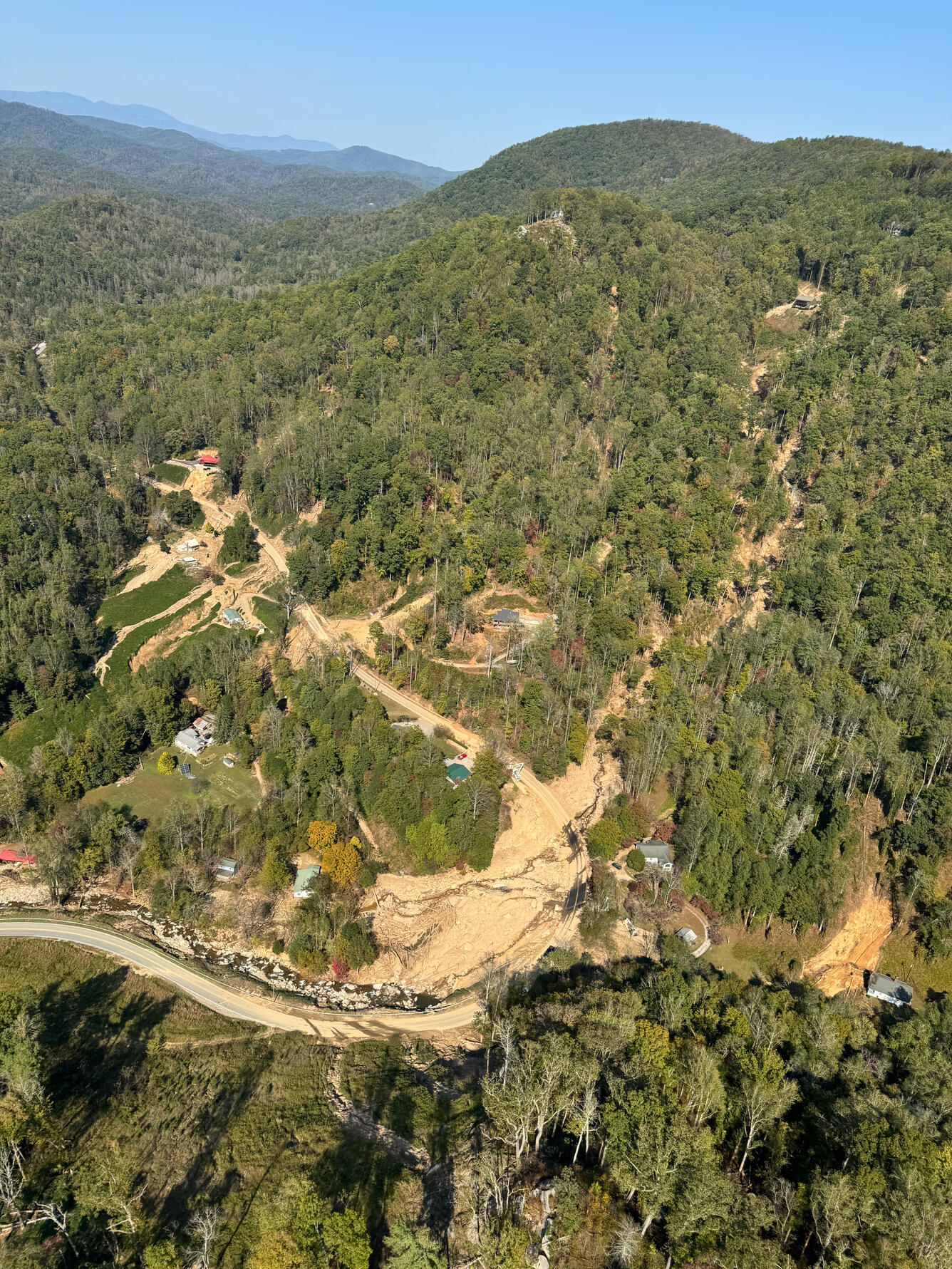
Western North Carolina was hit hardest. In Buncombe County alone, 43 people lost their lives as flood waters and mudflows swept down river valleys into nearby communities. Homes, and sometimes entire neighborhoods, in towns like Fairview, Bat Cave, and Black Mountain were buried under debris. Roads and power lines were destroyed. The Blue Ridge Parkway suffered massive damage from multiple landslides, cutting off access along parts of the iconic route.
“These types of events happen every few decades,” said Dr. Ben Mirus, a USGS research geologist. “But the sheer scale and speed of what we saw after Helene really pushed the limits of what communities—and scientists—were prepared for.”
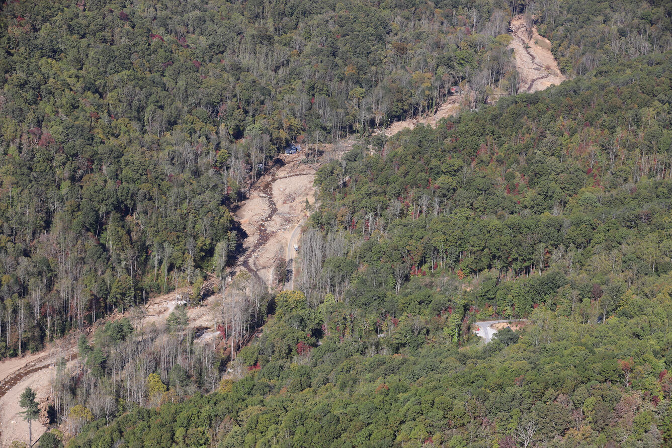
One of the deadliest landslides occurred in the community of Craigtown in Fairview, where at least 10 smaller landslides converged into a single channel that flowed through the community. Fast-moving mudflows traveled over a mile, destroying homes and claiming 13 lives.
“That’s how landslides can escalate,” Mirus explained. “Several small ones combine and become something much more dangerous.”
The hurricane rainfall on top of the saturated soils was a key trigger for the regional landsliding. Additionally, although rainfall varied considerably across the southeast, 95% of mapped landslides occurred in areas that received cumulative rainfall of 10 inches or more.
“The sheer scale and speed of what we saw after Helene really pushed the limits of what communities—and scientists—were prepared for.” - Ben Mirus

USGS Mobilizes for Rapid Response Following Hurricane Helene
As reports of landslides poured in, the USGS activated its Landslide Assessments, Situational Awareness, and Event Response, or LASER team. Within days, USGS scientists were sent to North Carolina, flying over the affected areas and characterizing the extent of the landslide activity before it was possible to obtain clear satellite imagery or access sites on the ground. This work helped emergency responders decide where to search for survivors, which roads were accessible, and what areas were still at risk.
“We joined a team of hundreds, working long hours for days on end. We had to get onto the ground and into the air to survey the true situation. It was only then that the vast scale of loss and destruction became much more real and sobering” said Kate Allstadt, USGS LASER project chief. “The stories of the residents who experienced this extreme event, including those of colleagues and friends in the region, brought home the human reality of this disaster.”
Over the next few weeks, USGS continued to support the Federal Emergency Management Agency, the North Carolina Geological Survey, and other first responders with their response and recovery efforts.
USGS personnel deployed to emergency operations centers conducted aerial surveys and field site visits across the hardest hit counties and advised emergency responders on landslide hazards. Additional USGS personnel continued to remotely map landslide locations, analyze slope conditions, and provide current hazard information through an online landslide dashboard. The team also created custom safety briefings for first responders—especially important for understanding how landslides behave.
“Landslides are like bulldozers,” said Stephen Slaughter, a USGS landslide geologist. “They don’t just hit one spot and stop. They keep pushing everything downhill and to the side—cars, buildings, trees. When a house is hit by a landslide, the debris doesn’t always stay near the house and can often end up hundreds of yards or even many miles downstream in valleys, creeks, or reservoirs.”
Throughout the deployment, scientists briefed local leaders daily. While no landslides posed an immediate major threat in the days following the storm, the team showed emergency responders things to keep an eye out for—slopes with cracks, seepage, or instability—warning that further rain or construction could cause reactivation in those locations.
The USGS’s work after Hurricane Helene didn’t end with the emergency response. Scientists continued to work and collaborate over the months that followed. By January 2025, the bureau had compiled an inventory of more than 2,200 landslides—one of the largest events on record for the region.
“This storm really changed the way many people think about landslide risk in the Appalachians,” Mirus said. “With the combination of potentially more frequent, intense storms and the presence of many more people living in the mountains, these kinds of events will likely continue to happen in the future.”
“The stories of the residents who experienced this extreme event brought home the human reality of this disaster.” - Kate Allstadt

Landslide Safety and Preparedness
In addition to providing emergency response support, the USGS also shared plain-language landslide safety materials with residents and responders.
Mirus explained that while there are several variations of what are generally called “landslides,” the term landslide technically refers to any downslope movement of earth materials. Specific types of landslides are then broken up into categories like rockfalls, debris flows, or earthflows, depending on the kind of material it’s comprised of and how it moves.
When it comes to landslide safety and preparedness, the advice is simple: get to higher ground, fast. Although landslide movement rates do vary, the speed of some mudflows can exceed 35 miles per hour and travel great distances, even after they hit flatter ground. There is no outrunning that. If you can’t avoid the path of landslide then getting to higher ground, whether in nature or in a building, has been shown to save lives in some instances.
Landslides are frequently marked by the sound of trees snapping, rocks hitting rocks, and you can feel the ground shaking like a train is passing, Slaughter said. “When you feel or hear these sensations, if in a two-story house, it’s too late to evacuate, so it’s urgent to get to the second floor immediately; in a single-story house, climb on top of a counter or desk.”
Slaughter also emphasized the importance of public awareness: “Landslides give off signs—cracks in the ground, leaning trees or utility poles, water where it shouldn’t be. If you notice something feels off, trust your gut. That awareness can save your life.”
"If you notice something feels off, trust your gut. That awareness can save your life.” - Stephen Slaughter
Building Resilience Through Science
Other than hurricanes and major rainfall, landslides can be triggered by snowmelt, earthquakes, and volcanic activity, and these hazards can be further exacerbated by human activities and wildfires. Mirus stressed that while landslides can occur with limited warning, local authorities in mountainous regions will often issue landslide warnings before major storm events.
“The best time to prepare for a landslide is before they are a problem for you,” Mirus said. “It could save your life.”
Understanding how and why slopes fail helps scientists build better forecasting tools. Additionally, updated hazard maps released by USGS help local governments plan safer development and evacuation routes.
The USGS continues to work with partners to monitor at-risk areas and provide resources to help communities prepare for future events. By leveraging science and collaboration, the goal is to enhance resilience and reduce the impact of natural disasters like flooding and landslides.
“Coordinated collaboration between agencies allowed for information to be rapidly collected, contextualized, and communicated,” said Lauren Schaefer, USGS LASER lead for Hurricane Helene response. “And these ongoing efforts continue to help inform landslide loss reduction in the region.”
Hurricane Helene stands as the impetus for one of the most damaging landslide events in Appalachian history. But thanks to federal resources and community partnerships, local leaders now have better tools—and better data—to prepare for what may come next.
“Hopefully, the tools and resources we’ve developed prove beneficial,” Mirus said. “And people can use them to better prepare and develop a plan that reduces the impacts of the next major weather disaster.”
“The best time to prepare for a landslide is before they are a problem for you. It could save your life.” - Ben Mirus
The United States’ primary federal program dedicated to landslide hazard science—the USGS Landslide Hazards Program—focuses on research and developing resources that save lives, protect property, and ultimately reduce the long-term losses related to landslides.
Learn More
- USGS Landslide Hazards Program
- Hurricane Helene Landslide Map Dashboard
- USGS Open-File Report on Helene Landslides
- Landslide Safety Guide (PDF)


Related

2024 Hurricane Helene Landslide Hazards

Landslide Assessments, Situational Awareness, and Event Response Research (LASER)
Related
2024 Hurricane Helene Landslide Hazards