



Hurricane Helene produced widespread damaging, and in some cases, deadly landslides. Hurricane Helene made landfall in Florida as a Category 4 storm on Thursday, September 26th, 2024. The hurricane continued across the southern Appalachian Mountains producing record rainfall and wind gusts, damaging flooding, and triggering over 2000 landslides. This page provides information about the extent and severity of the landslide impacts.
This landslide event page was initially created during the USGS Hurricane Helene landslide response (September 28th to October 25th, 2024) to communicate timely preliminary information to the public and partner agencies. Following the conclusion of the response, the page was updated with new findings and publications related to the event and formally reviewed. Last update: 8/10/2026.
Our thoughts go out to the millions of people affected by Hurricane Helene.
Field Photos | Observations | More Information | Publications | Data
Summary of Hurricane Helene Landslide Hazards
Hurricane Helene made landfall in Florida late on September 26, 2024, and continued northward across the southern Appalachian region (North Carolina, Tennessee, Virginia, and South Carolina) in the early morning of September 27, 2024, producing record rainfall and wind gusts. The soils in the region were already saturated by preceding rainfall, including a 2-day predecessor rain event. The maximum 72-hour rainfall total measured in western North Carolina, including the predecessor rain event and Hurricane Helene, was 30.8 inches (approx. 78.2 centimeters).1 This series of storms unleashed widespread and destructive flooding, landslides, and winds across the region. These hazards disrupted critical infrastructure including roads, power, and water, some of which persisted for many months.
- Over 2,200 landslides were identified in the initial weeks following the hurricane.2
- Over half of the identified landslides damaged structures, disrupted roads, or intersected rivers.2
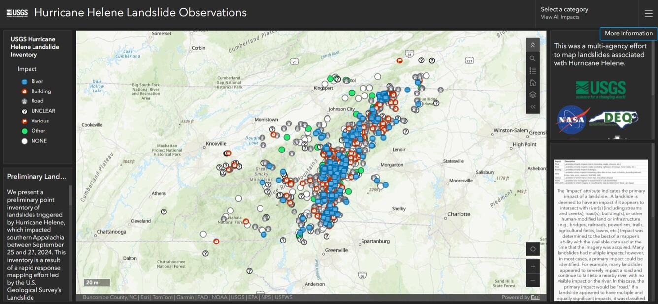
- Most of the landslides were located in western North Carolina in a north-south trend east of Asheville and northeast-southwest trend along the Blue Ridge Mountains (refer to USGS Hurricane Helene Landslide Dashboard for locations).2
- Landslides were shallow, initiating in soil on slopes between 15° and 35°.2
- Many of the shallow landslides subsequently incorporated enough water and sediment to mobilize into longer-runout debris flows. In a few cases, several debris flows coalesced into larger flows that traveled several miles/kilometers.3
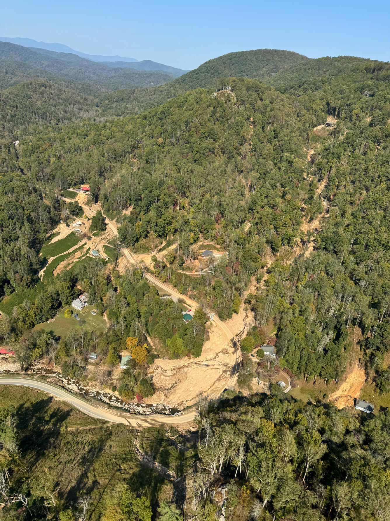
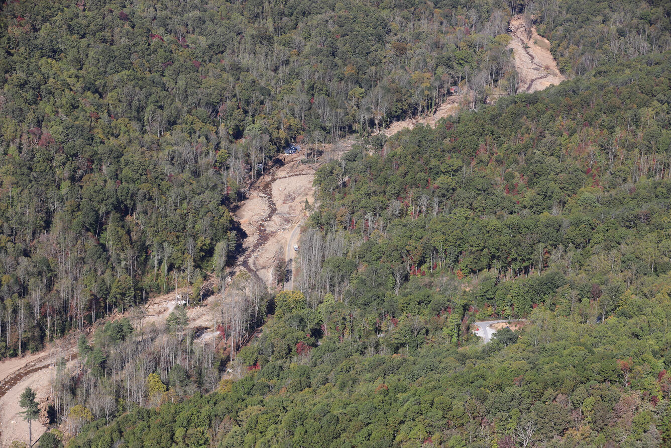
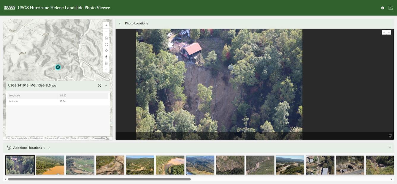
- Aerial photographs of selected sites representative of the range of landslide types and impacts that occurred can be viewed in the Field Photo section and additionally with geolocations in the USGS Hurricane Helene Landslide Photo Viewer.
Many additional landslides have since been identified by the North Carolina Geological Survey and their partners using higher resolution aerial imagery, lidar, and field visits; their mapping is ongoing with over 2,800 landslide outlines mapped to date.

Field Photos



The USGS Response to Hurricane Helene Landslide Hazards
The USGS Landslide Assessments, Situational Awareness, and Event Response Research (LASER) team was activated from September 28th to October 25th, 2024, to provide landslide technical assistance to local, state, and federal partner agencies responding to the event. The team conducted remote and field assessments of landslide hazards associated with the event, including rapidly mapping of landslides, which were shared in real time on the Hurricane Helene 2024 Landslide Observations Dashboard. The focus of the effort was to support state and local partners and provide situational awareness and educational materials for emergency response and recovery.
Products developed by the USGS during the landslide response to support situational awareness, such as landslide hazard estimate maps, aerial photographs from airplane and helicopter, satellite imagery products, and the final locations of landslides mapped during the response, can be accessed from the Hurricane Helene Landslide Response data release on ScienceBase. USGS landslide field assessment and safety information provided to responding agencies in the immediate aftermath are detailed in the Preliminary Field Report of Landslide Hazards Following Hurricane Helene.5
Although the LASER team response ended in October 2024, the USGS is still conducting post-response activities in collaboration with local and state partners and academic institutions. These include addressing questions related to where landslides initiated and travelled, characterizing ongoing and future hazards in the region, and advancing tools for landslide risk reduction based on findings from Helene. For example, in September 2025, the USGS, National Weather Service, North Carolina Geological Survey, Virginia Department of Energy, and University of North Carolina Asheville hosted the Weather and Landslides Workshop to strengthen understanding and communication between federal and state agencies, emergency responders, and county planners.
Regional Background
Hurricanes and heavy rain are known to trigger landslides in the Appalachian Mountains in the eastern United States.6 Landslides can block and damage roads, destroy homes, disrupt water supplies, cause injury, and take lives.
The first well-documented landslides following a storm in the southern Appalachians happened in 1916 when 22 inches (approximately 56 centimeters) of rain fell in 24 hours in western North Carolina. Hurricanes, other less intense storms, and even periods of above-average precipitation have triggered hundreds to thousands of landslides in North Carolina, Virginia, and West Virginia.7,8 Notable storms include Hurricanes Camille (1969), Agnes (1972), Juan (1985), Opal (1995), Isabel (2003), Frances and Ivan (2004), Cindy (2005), and Ernesto (2006). Hurricane Camille in 1969 was the deadliest, causing 150 deaths and triggering thousands of landslides in Nelson County, Virginia, during just eight hours.6
Debris flows are among the most destructive and dangerous types of landslides. They are common in the southern Appalachians, occurring during the hurricanes mentioned above and other less intense rainfall events. Mixtures of rocks, water, mud, and other debris, these flows can move very quickly and over long distances, often destroying everything in their path with little or no indication of an approaching landslide.
Knowing exactly when and where landslides occur is challenging. Many factors influence landslide occurrence such as rock and soil types, tectonic structure, slope, rainfall and climate, and vegetation and land cover. Past landslide data can help in predictions of future landsliding by developing maps of landslide susceptibility. Landslide monitoring, including long-term measurements of rainfall and hillslope wetness during and between landslide events, can also help develop tools for better landslide forecasting and situational awareness. Much of what we know about past landslides comes from local agencies, including many state geological surveys (such as North Carolina) who map these features following storm events. The USGS also compiles data to create future hazard maps. You can find these maps online here.
Normalized Difference Vegetation Index (NDVI) Change Map: https://doi.org/10.5066/P14KDUKK
Aerial Photographs from October 13-17, 2024: https://doi.org/10.5066/P1C5W3PQ
Aerial Photographs from October 3-5, 2024: https://doi.org/10.5066/P1EK8WIT
Preliminary Landslide Hazard Estimate Maps: https://doi.org/10.5066/P134ERB9
Preliminary Landslide Inventory: https://doi.org/10.5066/P14CHGKS
Publications
Allstadt, K.E., McBride, S.K., Godt, J.W., Slaughter, S.L., Baxstrom, K.W., Sobieszczyk, S., and Stull, A., 2025, Preliminary field report of landslide hazards following Hurricane Helene: U.S. Geological Survey Open-File Report 2025–1028, 15 p., https://doi.org/10.3133/ofr20251028.
Schaefer, L.N., Rengers, F.K., Mirus, B.B., Toney, L., Allstadt, K.A., Wooten, R., Moore, P. Burgi, P.M., Witt, A., Bilderback, E., Bauer, J., Korte, D., Crawford, M., 2025, Insights into widespread landsliding in southern Appalachia from Hurricane Helene. GSA Today, v. 36, p.4–11, https://doi.org/10.1130/GSATG625A.1.
Contributors to this page include Marísa Macías, Corina Cerovski-Darriau, Eric Bilderback, Lauren Schaefer, Lauren Palermo, Sonia Ellison, Jaime Kostelnik, Jocelyn West, Kate Allstadt, Paula Burgi, Robert Schmitt, Kelli Baxstrom, Emily Bedinger, Ben Mirus, Sabrina Martinez, Francis Rengers, and Sara McBride.
More Information
Learn more about federal response and FEMA guidance for Hurricane Helene.
Learn more about landslides.
Learn more about landslide preparedness.
Learn more about the National Landslide Susceptibility Map.
Learn more about the Landslide Hazards Program.
Learn more about USGS Landslide Response.
Learn more about landslides in North Carolina.
References
1 National Weather Service, 2024, Post tropical cyclone report [Hurricane Helene]: National Weather Service, 3 p., accessed March 11, 2025, at https://www.weather.gov/media/gsp/TropicalEventSummary/PSHGSP_2024AL09_Helene_ Summary.pdf.
2 Schaefer, L.N., Rengers, F.K., Mirus, B.B., Toney, L., Allstadt, K.A., Wooten, R., Moore, P. Burgi, P.M., Witt, A., Bilderback, E., Bauer, J., Korte, D., and Crawford, M., 2025, Insights into widespread landsliding in southern Appalachia from Hurricane Helene: GSA Today, v. 36, p. 4–11, https://doi.org/10.1130/GSATG625A.1.
3 Allstadt, K.E., McBride, S.K., Godt, J.W., Slaughter, S.L., Baxstrom, K.W., Sobieszczyk, S., and Stull, A., 2025, Preliminary field report of landslide hazards following Hurricane Helene: U.S. Geological Survey Open-File Report 2025-1028, 15 p., https://doi.org/10.3133/ofr20251028.
4 Mirus, B.B., Belair, G.M., Wood, N.J., Jones, J., and Martinez, S.N., 2024, Parsimonious High-resolution Landslide Susceptibility Modeling at Continental Scales: AGU Advances, v. 5, p. e2024AV001214, https://doi.org/10.1029/2024AV001214.
5 Allstadt, K.E., McBride, S.K., Godt, J.W., Slaughter, S.L., Baxstrom, K.W., Sobieszczyk, S., and Stull, A., 2025, Preliminary field report of landslide hazards following Hurricane Helene: U.S. Geological Survey Open-File Report 2025–1028, 15 p., https://doi.org/10.3133/ofr20251028.
6Wieczorek, G.F., Eaton, L.S., Morgan, B.A., Wooten, R.M., and Morrissey, M., 2009, An examination of selected historical rainfall-induced debris-flow events within the central and southern Appalachian Mountains of the Eastern United States: U.S. Geological Survey Open-File Report 2009-1155, 25 p., https://doi.org/10.3133/ofr20091155.
7 Wooten, R. M., Witt, A.C., Miniat, C.F., Hales, T.C., Aldred, J.L., 2016, Frequency and magnitude of selected historical landslide events in the southern Appalachian Highlands of North Carolina and Virginia: Relationships to rainfall, geological and ecohydrological controls, and effects. In: Greenberg and C., Collins, B. (eds.) Natural Disturbances and Historic Range of Variation: Type, Frequency, Severity, and Post-Disturbance Structure in Central Hardwood Forests USA. Springer Cham.: Managing Forest Ecosystems, v. 32, p. 203–262, https://doi.org/10.1007/978-3-319-21527-3_9.
8 Hill, J., Wooten, R., Cattanach, B., Bauer, J., Bozdog, N., Douglas, T., Isard, S., Khashchevskaya, D., Korte, D., Kuhne, J., Owen, L., Prince, P., Scheip, C., Waters-Tormey, C., and Wegmann, K., 2024, Big slow-movers, debris slides and flows, and mega-boulders of the Blue Ridge Escarpment, western North Carolina, USA. In: Merschat, A. J. and Carter, M. W. (eds.) Geology and Geologic Hazards of the Blue Ridge: Field Excursions for the 2024 GSA Southeastern Section Meeting, Asheville, North Carolina, USA. Boulder, Colorado: The Geological Society of America Field Guide, v. 67, p. 13–67, https:/doi.org/10.1130/2024.0067(022).
Landslide Safety
Landslide Preparedness
Hurricane Helene produced widespread damaging, and in some cases, deadly landslides. Hurricane Helene made landfall in Florida as a Category 4 storm on Thursday, September 26th, 2024. The hurricane continued across the southern Appalachian Mountains producing record rainfall and wind gusts, damaging flooding, and triggering over 2000 landslides. This page provides information about the extent and severity of the landslide impacts.
This landslide event page was initially created during the USGS Hurricane Helene landslide response (September 28th to October 25th, 2024) to communicate timely preliminary information to the public and partner agencies. Following the conclusion of the response, the page was updated with new findings and publications related to the event and formally reviewed. Last update: 8/10/2026.
Our thoughts go out to the millions of people affected by Hurricane Helene.
Field Photos | Observations | More Information | Publications | Data
Summary of Hurricane Helene Landslide Hazards
Hurricane Helene made landfall in Florida late on September 26, 2024, and continued northward across the southern Appalachian region (North Carolina, Tennessee, Virginia, and South Carolina) in the early morning of September 27, 2024, producing record rainfall and wind gusts. The soils in the region were already saturated by preceding rainfall, including a 2-day predecessor rain event. The maximum 72-hour rainfall total measured in western North Carolina, including the predecessor rain event and Hurricane Helene, was 30.8 inches (approx. 78.2 centimeters).1 This series of storms unleashed widespread and destructive flooding, landslides, and winds across the region. These hazards disrupted critical infrastructure including roads, power, and water, some of which persisted for many months.
- Over 2,200 landslides were identified in the initial weeks following the hurricane.2
- Over half of the identified landslides damaged structures, disrupted roads, or intersected rivers.2
- Most of the landslides were located in western North Carolina in a north-south trend east of Asheville and northeast-southwest trend along the Blue Ridge Mountains (refer to USGS Hurricane Helene Landslide Dashboard for locations).2
- Landslides were shallow, initiating in soil on slopes between 15° and 35°.2
- Many of the shallow landslides subsequently incorporated enough water and sediment to mobilize into longer-runout debris flows. In a few cases, several debris flows coalesced into larger flows that traveled several miles/kilometers.3
- Aerial photographs of selected sites representative of the range of landslide types and impacts that occurred can be viewed in the Field Photo section and additionally with geolocations in the USGS Hurricane Helene Landslide Photo Viewer.
Many additional landslides have since been identified by the North Carolina Geological Survey and their partners using higher resolution aerial imagery, lidar, and field visits; their mapping is ongoing with over 2,800 landslide outlines mapped to date.
Field Photos
The USGS Response to Hurricane Helene Landslide Hazards
The USGS Landslide Assessments, Situational Awareness, and Event Response Research (LASER) team was activated from September 28th to October 25th, 2024, to provide landslide technical assistance to local, state, and federal partner agencies responding to the event. The team conducted remote and field assessments of landslide hazards associated with the event, including rapidly mapping of landslides, which were shared in real time on the Hurricane Helene 2024 Landslide Observations Dashboard. The focus of the effort was to support state and local partners and provide situational awareness and educational materials for emergency response and recovery.
Products developed by the USGS during the landslide response to support situational awareness, such as landslide hazard estimate maps, aerial photographs from airplane and helicopter, satellite imagery products, and the final locations of landslides mapped during the response, can be accessed from the Hurricane Helene Landslide Response data release on ScienceBase. USGS landslide field assessment and safety information provided to responding agencies in the immediate aftermath are detailed in the Preliminary Field Report of Landslide Hazards Following Hurricane Helene.5
Although the LASER team response ended in October 2024, the USGS is still conducting post-response activities in collaboration with local and state partners and academic institutions. These include addressing questions related to where landslides initiated and travelled, characterizing ongoing and future hazards in the region, and advancing tools for landslide risk reduction based on findings from Helene. For example, in September 2025, the USGS, National Weather Service, North Carolina Geological Survey, Virginia Department of Energy, and University of North Carolina Asheville hosted the Weather and Landslides Workshop to strengthen understanding and communication between federal and state agencies, emergency responders, and county planners.
Regional Background
Hurricanes and heavy rain are known to trigger landslides in the Appalachian Mountains in the eastern United States.6 Landslides can block and damage roads, destroy homes, disrupt water supplies, cause injury, and take lives.
The first well-documented landslides following a storm in the southern Appalachians happened in 1916 when 22 inches (approximately 56 centimeters) of rain fell in 24 hours in western North Carolina. Hurricanes, other less intense storms, and even periods of above-average precipitation have triggered hundreds to thousands of landslides in North Carolina, Virginia, and West Virginia.7,8 Notable storms include Hurricanes Camille (1969), Agnes (1972), Juan (1985), Opal (1995), Isabel (2003), Frances and Ivan (2004), Cindy (2005), and Ernesto (2006). Hurricane Camille in 1969 was the deadliest, causing 150 deaths and triggering thousands of landslides in Nelson County, Virginia, during just eight hours.6
Debris flows are among the most destructive and dangerous types of landslides. They are common in the southern Appalachians, occurring during the hurricanes mentioned above and other less intense rainfall events. Mixtures of rocks, water, mud, and other debris, these flows can move very quickly and over long distances, often destroying everything in their path with little or no indication of an approaching landslide.
Knowing exactly when and where landslides occur is challenging. Many factors influence landslide occurrence such as rock and soil types, tectonic structure, slope, rainfall and climate, and vegetation and land cover. Past landslide data can help in predictions of future landsliding by developing maps of landslide susceptibility. Landslide monitoring, including long-term measurements of rainfall and hillslope wetness during and between landslide events, can also help develop tools for better landslide forecasting and situational awareness. Much of what we know about past landslides comes from local agencies, including many state geological surveys (such as North Carolina) who map these features following storm events. The USGS also compiles data to create future hazard maps. You can find these maps online here.
Normalized Difference Vegetation Index (NDVI) Change Map: https://doi.org/10.5066/P14KDUKK
Aerial Photographs from October 13-17, 2024: https://doi.org/10.5066/P1C5W3PQ
Aerial Photographs from October 3-5, 2024: https://doi.org/10.5066/P1EK8WIT
Preliminary Landslide Hazard Estimate Maps: https://doi.org/10.5066/P134ERB9
Preliminary Landslide Inventory: https://doi.org/10.5066/P14CHGKS
Publications
Allstadt, K.E., McBride, S.K., Godt, J.W., Slaughter, S.L., Baxstrom, K.W., Sobieszczyk, S., and Stull, A., 2025, Preliminary field report of landslide hazards following Hurricane Helene: U.S. Geological Survey Open-File Report 2025–1028, 15 p., https://doi.org/10.3133/ofr20251028.
Schaefer, L.N., Rengers, F.K., Mirus, B.B., Toney, L., Allstadt, K.A., Wooten, R., Moore, P. Burgi, P.M., Witt, A., Bilderback, E., Bauer, J., Korte, D., Crawford, M., 2025, Insights into widespread landsliding in southern Appalachia from Hurricane Helene. GSA Today, v. 36, p.4–11, https://doi.org/10.1130/GSATG625A.1.
Contributors to this page include Marísa Macías, Corina Cerovski-Darriau, Eric Bilderback, Lauren Schaefer, Lauren Palermo, Sonia Ellison, Jaime Kostelnik, Jocelyn West, Kate Allstadt, Paula Burgi, Robert Schmitt, Kelli Baxstrom, Emily Bedinger, Ben Mirus, Sabrina Martinez, Francis Rengers, and Sara McBride.
More Information
Learn more about federal response and FEMA guidance for Hurricane Helene.
Learn more about landslides.
Learn more about landslide preparedness.
Learn more about the National Landslide Susceptibility Map.
Learn more about the Landslide Hazards Program.
Learn more about USGS Landslide Response.
Learn more about landslides in North Carolina.
References
1 National Weather Service, 2024, Post tropical cyclone report [Hurricane Helene]: National Weather Service, 3 p., accessed March 11, 2025, at https://www.weather.gov/media/gsp/TropicalEventSummary/PSHGSP_2024AL09_Helene_ Summary.pdf.
2 Schaefer, L.N., Rengers, F.K., Mirus, B.B., Toney, L., Allstadt, K.A., Wooten, R., Moore, P. Burgi, P.M., Witt, A., Bilderback, E., Bauer, J., Korte, D., and Crawford, M., 2025, Insights into widespread landsliding in southern Appalachia from Hurricane Helene: GSA Today, v. 36, p. 4–11, https://doi.org/10.1130/GSATG625A.1.
3 Allstadt, K.E., McBride, S.K., Godt, J.W., Slaughter, S.L., Baxstrom, K.W., Sobieszczyk, S., and Stull, A., 2025, Preliminary field report of landslide hazards following Hurricane Helene: U.S. Geological Survey Open-File Report 2025-1028, 15 p., https://doi.org/10.3133/ofr20251028.
4 Mirus, B.B., Belair, G.M., Wood, N.J., Jones, J., and Martinez, S.N., 2024, Parsimonious High-resolution Landslide Susceptibility Modeling at Continental Scales: AGU Advances, v. 5, p. e2024AV001214, https://doi.org/10.1029/2024AV001214.
5 Allstadt, K.E., McBride, S.K., Godt, J.W., Slaughter, S.L., Baxstrom, K.W., Sobieszczyk, S., and Stull, A., 2025, Preliminary field report of landslide hazards following Hurricane Helene: U.S. Geological Survey Open-File Report 2025–1028, 15 p., https://doi.org/10.3133/ofr20251028.
6Wieczorek, G.F., Eaton, L.S., Morgan, B.A., Wooten, R.M., and Morrissey, M., 2009, An examination of selected historical rainfall-induced debris-flow events within the central and southern Appalachian Mountains of the Eastern United States: U.S. Geological Survey Open-File Report 2009-1155, 25 p., https://doi.org/10.3133/ofr20091155.
7 Wooten, R. M., Witt, A.C., Miniat, C.F., Hales, T.C., Aldred, J.L., 2016, Frequency and magnitude of selected historical landslide events in the southern Appalachian Highlands of North Carolina and Virginia: Relationships to rainfall, geological and ecohydrological controls, and effects. In: Greenberg and C., Collins, B. (eds.) Natural Disturbances and Historic Range of Variation: Type, Frequency, Severity, and Post-Disturbance Structure in Central Hardwood Forests USA. Springer Cham.: Managing Forest Ecosystems, v. 32, p. 203–262, https://doi.org/10.1007/978-3-319-21527-3_9.
8 Hill, J., Wooten, R., Cattanach, B., Bauer, J., Bozdog, N., Douglas, T., Isard, S., Khashchevskaya, D., Korte, D., Kuhne, J., Owen, L., Prince, P., Scheip, C., Waters-Tormey, C., and Wegmann, K., 2024, Big slow-movers, debris slides and flows, and mega-boulders of the Blue Ridge Escarpment, western North Carolina, USA. In: Merschat, A. J. and Carter, M. W. (eds.) Geology and Geologic Hazards of the Blue Ridge: Field Excursions for the 2024 GSA Southeastern Section Meeting, Asheville, North Carolina, USA. Boulder, Colorado: The Geological Society of America Field Guide, v. 67, p. 13–67, https:/doi.org/10.1130/2024.0067(022).