
Landslide Assessments, Situational Awareness, and Event Response Research (LASER)
Landslide crises can unfold in many ways, but in all cases, responders and the public need information about what happened and what might happen next as soon as possible.
The LASER project seeks to provide event-driven information products and assessments for landslide events to help guide decision-making and inform the public. The project also conducts research and development aimed towards improving our capacity to rapidly detect, map, monitor, and characterize landslide hazards.


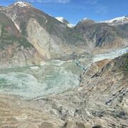
2025 M7.0 Hubbard Glacier Earthquake-Triggered Landslides and Snow Avalanches
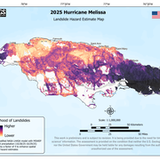
2025 Hurricane Melissa Landslide Hazards
2025 Tracy Arm Landslide-Generated Tsunami

2024 Hurricane Helene Landslide Hazards

2024 Pedersen Glacier Lagoon Landslide-Generated Tsunami

Preliminary Analysis of Satellite Imagery and Seismic Observations of the Nuugaatsiaq Landslide and Tsunami, Greenland

Reconstruction of an Avalanche: The West Salt Creek Rock Avalanche
Landslide crises can unfold in many ways, but in all cases, responders and the public need information about what happened and what might happen next as soon as possible.
The LASER project seeks to provide event-driven information products and assessments for landslide events to help guide decision-making and inform the public. The project also conducts research and development aimed towards improving our capacity to rapidly detect, map, monitor, and characterize landslide hazards.
2025 M7.0 Hubbard Glacier Earthquake-Triggered Landslides and Snow Avalanches
2025 Hurricane Melissa Landslide Hazards
2025 Tracy Arm Landslide-Generated Tsunami
2024 Hurricane Helene Landslide Hazards
2024 Pedersen Glacier Lagoon Landslide-Generated Tsunami
Preliminary Analysis of Satellite Imagery and Seismic Observations of the Nuugaatsiaq Landslide and Tsunami, Greenland