
Mineral Science Reaches New Heights
When learning more about ancient rocks buried deep beneath the surface of the Earth, it may seem surprising to use futuristic technologies flown hundreds of feet in the air, but that has been central to the USGS Earth Mapping Resource Initiative. One year in, it’s time to take stock of what Earth MRI has achieved & where it’s going, using the results of a recent survey to lead the way.
Mapping a Hidden Volcanic Terrane under America’s Heartland
In late 2019, residents near the confluence of the Ohio and Wabash Rivers might have noticed a small aircraft zig-zagging low in the sky over farms and country roads. This plane was in the process of scanning deep under the surface of the Earth to learn more about the region’s turbulent geologic past.
“When we think of southern Illinois and western Kentucky, we might envision rolling green hills, farm fields and the Ohio River. We don’t typically think of volcanic rocks that originated from magmas deep within the mantle and exploded their way through thousands of feet of older sedimentary rock. But that’s just what’s happened around 270 million years ago under what is now southern Illinois and western Kentucky,” said USGS scientist Anne McCafferty, who led the survey.

Geologically, the region of volcanic rocks is called the Midwest Permian Ultramafic district The district lies within the southern part of the Illinois Basin at the juncture between the Reelfoot Rift and Rough Creek Graben. The Reelfoot Rift and Rough Creek Graben are thought to have formed 750 million years ago during the Precambrian. Today, these geologic features are the focus of modern-day earthquake activity as part of the New Madrid and Wabash Valley seismic zones.
In addition to a potential for seismic hazards, this region is of great interest for its mineral resource potential and is the location for the Illinois-Kentucky fluorspar mineral district. Deposits in the mineral district are hosted in sedimentary rock with some of the mineralization presumed to be connected to the ultramafic rocks. The Illinois-Kentucky fluorspar mineral district was once a major source for America’s fluorspar, a critical mineral commodity that is mainly used today in the manufacture of aluminum, gasoline, and uranium fuel. Other mineral commodities that occur in the area include significant amounts of lead, zinc, barite, cadmium, and germanium. The ultramafic rocks can also be a potential source for rare earth elements and titanium mineralization.
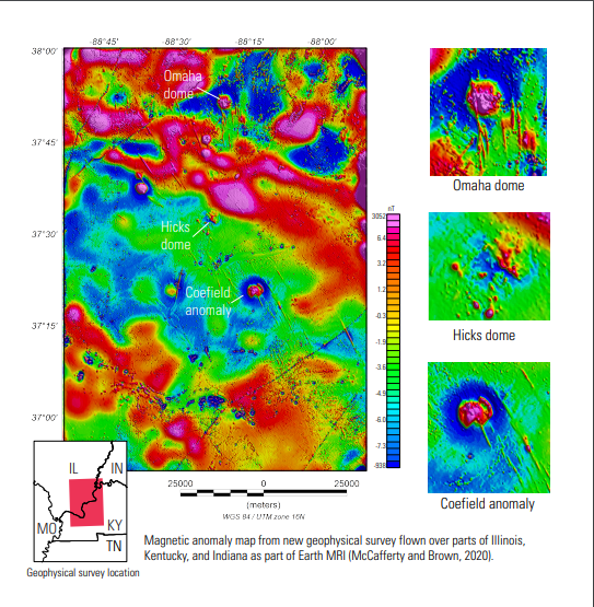
Within the fluorspar and ultramafic districts sit several geologic features of great interest for their mineral potential, including Hicks Dome, the Coefield magnetic anomaly, and Omaha Dome.

“Rare earth elements, titanium, and fluorspar are a few of the mineral commodities the Department of the Interior deemed critical to the economy and security of the United States, so we’re very interested in learning more about the geology of this underexplored area of the Midcontinent,” explained McCafferty. “Since this region is known for several critical-mineral deposit types, the geology drew our attention for a closer look.”
Ultramafic rocks are extremely rich in magnesium and iron and typically contain small amounts of the mineral magnetite. Magnetite in rocks produces magnetic anomalies that can be mapped using modern airborne surveying technologies. That’s why McCafferty and her colleagues turned to the sky to see under the ground.
The results of the survey brought Hicks Dome, Omaha Dome, and the Coefield Anomaly into clear focus.
“You can see the magnetic anomaly signatures of these features,” McCafferty said. “Both Omaha Dome and the Coefield Anomaly are well defined against the non-magnetic rock of the surrounding area, and the results over Hicks Dome provides us with increased insight into the geology of this enigmatic mineral feature.”
The new airborne geophysical survey will give resource managers and decision makers in the region valuable insights into the mineral potential in the lower Ohio River Valley as well as help characterize the seismic hazards associated with the New Madrid fault zone.
Criss-crossing the Country for Critical Minerals
Over the past year, several other surveys similar to the one over Hicks Dome have been conducted as part of the Earth MRI project. Recent flights have mapped areas in South Carolina, the Mojave Desert of California and Nevada, and northern Arkansas. Similar to the lower Ohio River Valley survey, the mineral commodities of interest for these flights have been the rare earth elements.
Vital for many electronics, renewable energy, and defense applications, the rare earth elements are one of the 35 mineral commodities designated by the Department of the Interior as critical to the Nation’s economy and security. In its first year, Earth MRI chose to focus primarily on the rare earths as test cases for determining how to proceed with mapping for the other 35 commodities.
In addition to the airborne geophysical survey, Earth MRI has also conducted two other types of surveys: lidar and geologic mapping surveys.
Lidar, which uses lasers to produce high-resolution topographic maps, helps identify surface rock formations especially when there is heavy vegetation covering the rocks. Lidar surveys are also conducted from an airplane and were flown as separate efforts over the Mojave Desert and the Lower Ohio River Valley survey areas. In addition, areas of interest in southern Idaho and southern Virginia were also mapped with lidar.
Geologic maps supplement the data from airborne geophysical surveys and give a more wholistic understanding of the mineral potential in a region. In addition to the Mojave Desert and lower Ohio River Valley, Earth MRI worked with state geological survey partners in Alabama, Alaska, Arkansas, Idaho, Illinois, Kentucky, Maryland, New Mexico, North Carolina, South Carolina, Virginia and West Virginia to conduct geologic mapping in their states.
All of these projects can be accessed here.

Start with Science
These projects represent just a small fraction of the area of the United States that needs to be mapped for resource potential. Very little of the country has been covered with aeromagnetic data that fully meet modern standards and best practices.
“Although our survey of the Lower Ohio River Valley is a good start, we still have a long way to go,” said McCafferty. “The new geophysical survey covers only 3.8 percent of Illinois, 5.5 percent of Kentucky, and less than 1 percent of Indiana.”
To remedy the lack of high-quality data, another airborne geophysical campaign is planned for the fall of 2020 and will augment the IL/KY/IN survey along its west side. The survey is being supported by the USGS Earth MRI, with additional funding provided by the Missouri Geological Survey and the USGS National Cooperative Geologic Mapping Program. The survey is being called the “Gap” survey as it will fill a gap between two high-quality geophysical surveys acquired by the USGS from 2014 to 2019.
This project will join 22 other partnerships across the country as part of Earth MRI’s 2020 project selections, collecting airborne geophysical data, lidar, geologic mapping and geochemistry in 21 states. A total of \$6.54 million in funding will be devoted to the effort.
“I’m very excited to see my project and these others move forward,” said McCafferty. “It’s a fantastic opportunity to partner with the states to bring our understanding of the Nation’s geologic story to the next level.”
A full list of Earth MRI’s 2020 projects can be found here. More information on Earth MRI may be found here. To keep up-to-date on USGS mineral science, follow us on Twitter.