



Our Impact
Earth MRI is making an impact across the Nation. These are stories of Earth MRI in action.
Earth MRI is making an impact across the Nation. These are stories of Earth MRI in action.
Our Partners
Partnerships are central to Earth MRI. Learn how they benefit the Nation.
Partnerships are central to Earth MRI. Learn how they benefit the Nation.
Connect with Us
Earth Mapping Resources Initiative (Earth MRI)
Earth MRI is modernizing mapping of the Nation's surface and subsurface. We deliver high-quality data needed to understand our Nation's geology, find new critical and other mineral resources, and inform decisions about how the Nation will meet its evolving needs.
What is Earth MRI?
What is Earth MRI?

Earth MRI is an initiative within the USGS Mineral Resources Program.
Mapping and Science
Mapping and Science

We collect multiple types of data across the full extent of the Nation.
Explore our Data
Explore our Data

Explore Earth MRI mapping areas and data through this interactive web-tool.
News
Media Alert: Low-level airplane and helicopter flights to resume scanning geology over southern, central New Mexico
Media Alert: Low-level airplane and helicopter flights to resume scanning geology over southern, central New Mexico
Media Alert: Low-level flights to image geology of northeast Nevada
Media Alert: Low-level flights to image geology of northeast Nevada
Media Alert: Low-level flights to image geology of eastern North Dakota
Media Alert: Low-level flights to image geology of eastern North Dakota
Publications
Geochemical, mineralogical, and isotopic evidence for multi-stage genesis of the Hicks Dome REE + Y-HFSE-fluorite deposit, Illinois, USA Geochemical, mineralogical, and isotopic evidence for multi-stage genesis of the Hicks Dome REE + Y-HFSE-fluorite deposit, Illinois, USA
Hicks Dome hosts breccias enriched in rare earth elements (REE), Y, Th, F, Ba, Ti, Nb, and Be, alongside spatially associated lamprophyre dikes (ca. 271 Ma). Hicks Dome is located within the Illinois–Kentucky Fluorspar District, which hosts fluorite, Pb–Zn, and barite resources. This study investigates the genetic relationships between Hicks Dome mineralization in breccias, alkaline...
New maps of natural radioactivity reveal critical minerals and more New maps of natural radioactivity reveal critical minerals and more
High-resolution airborne radiometric surveys are covering more ground than ever to provide insights into unseen geology, mineral resource potential, and possible health hazards.
Science

Geologic Map of Alaska
In January 2016, the U.S. Geological Survey released the first ever digital geologic map of Alaska. This map reflects more than a century of work and provides a visual context for the abundant mineral and energy resources found throughout the state. The map also is available to use in three different formats: a professional GIS database, a public interactive version via a web browser, and an...

Alaska Earth Mapping Resources Initiative (Earth MRI)
Our objective is to provide a strategic framework for planning, coordination, and execution of the USGS Earth Mapping Resources Initiative (Earth MRI) in Alaska. Earth MRI aims to improve knowledge of the U.S. geologic framework through new geological and geophysical mapping and to identify areas that have the potential to contain undiscovered critical mineral resources.
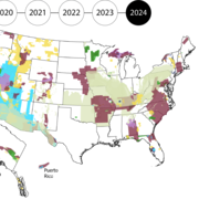
Earth MRI Progress
The U.S. needs high-quality geologic data to identify critical and other mineral resources, energy resources, make important land use decisions, and identify natural disasters. Since 2019, Earth MRI has advanced modern mapping of the US through the collection of geophysical, geochemical, geologic, topographic, hyperspectral, mine waste and other data, focusing on areas with the potential for...