
Natural Hazards of 2016
A reminder of the dangers we face and the need for preparedness to save lives and property.
Reflecting on 2016 hazards serves as a reminder of the dangers we face and the need for preparedness to save lives and property.
Every day in the United States, natural hazard events have the potential to harm lives, communities and the economic security of the nation. The USGS works with partners to monitor, assess and conduct research on a wide range of natural hazards so that policymakers and the public have the understanding they need to enhance preparedness, response and resilience.
Below is a summary of some significant natural hazard events that occurred last year. By understanding the consequences of these events, we raise our awareness of natural hazard risks and relate the importance of USGS science to protect communities, infrastructure and our economy.
Earthquakes and Landslides
Several large earthquakes followed by aftershock sequences were reported around the world by the USGS National Earthquake Information Center. These include earthquakes with a disastrous magnitude 7.8 in Ecuador, a magnitude 7.8 in New Zealand and a magnitude 7.0 in Japan. In central Italy, a magnitude 6.6 event occurred on October 30th as part of a complex, multi-year sequence of deadly earthquakes in the county.
The earthquake in New Zealand triggered an estimated 80,000 landslides. The USGS assisted New Zealand’s GNS Science in assessing the stability and potential impacts of landslides blocking stream channels in this mountainous region.
In the United States, Oklahoma was struck by several earthquakes, including a magnitude 5.8 earthquake on September 3rd; this is the largest recorded earthquake in the state. This earthquake is thought to have been triggered by wastewater injection, as many earthquakes in Oklahoma, Kansas and elsewhere have been triggered by fluid injection. The USGS and its state and university partners continue to perform research and monitoring to document the causes and consequences of human-induced seismicity.
USGS science plays a vital role in understanding and preparing communities for earthquake hazards at home and abroad. For the first time, new USGS maps identify potential ground-shaking hazards from both human-induced and natural earthquakes. In the past, USGS maps only identified natural earthquake hazards. By including human-induced events, the USGS assessment of earthquake hazards has significantly increased in parts of the United States.

Toxic Algal Blooms found Nationwide

A first-of-its-kind survey was conducted this year showing that algal toxins are found in lakes nationwide. Harmful algal blooms can be caused by numerous species of algae and bacteria, and this assessment focused on those caused by cyanobacteria. Toxins produced by cyanobacteria are known to have a range of lethal and non-lethal effects on humans, wildlife and companion animals. The assessment shows the scope of the problem and will help inform health advisories and regulations. Research was conducted by the USGS and the U.S. Environmental Protection Agency.
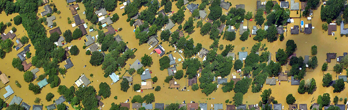
Flooding in Texas, Virginia, West Virginia, Iowa, Wisconsin, Louisiana and More
Many communities across the nation experienced severe flooding in 2016, and the USGS had crews on the ground to assist. The USGS works with many partners to provide essential data needed for flood forecasts, watches and warnings, and to help emergency managers direct response activities. The USGS national network of streamgages provides real-time information on water level and flow in the nation’s rivers and streams.
In the first half of the year, significant flooding occurred in Texas. Our scientists developed the USGS Texas Water Dashboard to integrate USGS data with other flood information and accompanying Twitter feeds, @USGS_TexasFlood and @USGS_TexasRain.
March saw damaging flooding in central and northern Louisiana. Later in the year, extensive rainfall led to flooding in Virginia and West Virginia, prompting a federal disaster declaration in those states, and damaging floods in Iowa and Wisconsin. Louisiana saw a second round of flooding, with historic records set in South Louisiana; where at least six USGS streamgages set a peak of record, and two showed a rise of 30 feet in two to three days.
Drought across the Nation
Half of the nation is experiencing abnormally dry conditions, and about two percent is experiencing exceptional drought. In addition to floods, the USGS streamgage network helps forecast and understand drought events. Drought is especially evident as streamflow conditions hit record lows throughout the west last year, particularly in California. The state is currently in its fifth year of severe drought. Concern is also now facing the Southeast, especially Alabama and Georgia, as well as the Northeast, from New Jersey to Maine.
Hurricanes Matthew and Hermine
Hurricanes Hermine and Matthew brought significant rain, storm surge, beach erosion and inland and coastal flooding. This caused disruption and damage to property and loss of life. USGS science and data efforts during and after these events help emergency managers prepare for and respond to storms, provide rapid assessment of impacts to guide recovery efforts, and contribute to improved forecasts of future storms.

New tools relying on USGS science provide the ability to predict – more precisely than ever – where beachfront erosion and flooding are likely. For example, they helped forecast likely erosion along more than 80 to 95 percent of the Florida, Georgia and South Carolina coast from Hurricane Matthew.
Furthermore, the USGS provided data on water level and flow through its streamgage network and installed storm-tide sensors during each hurricane in cooperation with the National Weather Service. These instruments measure how high storm surges get during severe storms and are installed on bridges, piers and other solid structures that can withstand the heavy wind and waves.
Wildfires Sweep through the Southeast
For the entire year, more than 5 million acres were burned by wildfires across the country. This is slightly lower than the national yearly average of 6.8 million acres for the past 10 years. In 2015, almost 10 million acres were burned from wildfires.
Towards the end of the year, fires swept through Georgia, North Carolina, South Carolina and Tennessee. The events resulted in casualties, brought devastation to homes and businesses and caused several communities to evacuate. Firefighters have contained or slowed the progress for most fires at this time. The USGS deployed streamgages to support the National Weather Service and produced assessments to help determine the risk for flash floods and debris flow.
The USGS also provides tools and information before, during and after fire disasters to identify wildfire risks and reduce subsequent hazards, including delivery to fire managers of up-to-the minute maps and satellite imagery about current wildfire extent and behavior.
Volcanic Activity
In Hawaii, Kīlauea volcano is at an Orange/Watch alert level and is erupting in two locations, but neither poses a threat to nearby communities. Mauna Loa remains at a Yellow/Advisory alert level since September 2015 due to sustained, low-level unrest.
In Alaska, Bogoslof volcano erupted in December and produced an ash cloud as high as 35,000 feet. At the time of this story's publication, it is at an Orange/Watch alert level. Pavlof volcano erupted in March, May and late July, and is currently at a Yellow/Advisory alert level, meaning it is still exhibiting signs of unrest. Scientists visited the volcano in early July and made repairs and digital upgrades to the seismic monitoring network, increasing the ability to monitor activity. Also in Alaska, explosions were detected at Cleveland volcano in April, May and October, and the volcano was downgraded in November to a Yellow/Advisory alert level.
The USGS is the agency responsible for monitoring the nation’s volcanoes. The United States has approximately 169 active volcanoes, and more than half of them could erupt explosively and threaten aviation and communities. The USGS has established a two-part alert-notification system for volcanic activity that includes tiered color codes for aviation (Green, Yellow, Orange and Red) and alert levels for ground hazards (Normal, Advisory, Watch and Warning).
Start with Science
These events are just a sampling of the major hazard events that occurred in 2016. There are many other issues of concern—from geomagnetic storms to avian flu and environmental health. Natural hazard events will continue, but with an enhanced scientific understanding and effective preparedness, the devastation and destruction can be reduced.
While natural disasters can be devastating, the USGS is dedicated to learning from events and making progress with innovative research and technology to build more resilient and safer communities.
