
100K OnDemand Topo Cartographic Specifications - Version History
This page highlights version history and details the refinements made to the published 100K Topo Cartographic Specifications.
Click a version number to jump to the associated history notes:
1.0 | 1.1 | 1.2 | 1.3 | 1.4 | 1.5 | 1.6 | 2.0
2026:
Version 2.0
Published: 6/4/2026
Summary: Reformatted, reviewed, and revised 100K Transportation cartographic specifications.
Transportation
- Reformatted cartographic specifications to a bullet-list format
- Refreshed images and standardized image description
Version 1.6
Published: 6/3/2026
Summary: Reformatted, reviewed, and revised 100K Government Units cartographic specifications.
Government Units
- Reformatted cartographic specifications to a bullet-list format
- Refreshed images and standardized image descriptions
Version 1.5
Published: 5/27/2026
Summary: Reformatted, reviewed, and revised 100K Structures cartographic specifications.
Structures
- Reformatted cartographic specifications to a bullet-list format
- Refreshed images and standardized image descriptions
Version 1.4
Published: 5/12/2026
Summary: Reformatted, reviewed, and revised 100K Geographic Names cartographic specifications.
Geographic Names
- Reformatted cartographic specifications to a bullet-list format
- Refreshed images and standardized image descriptions
Version 1.3
Published: 5/5/2026
Summary: Reformatted, reviewed, and revised 100K Elevation and Land Cover cartographic specifications themes.
Elevation
- Reformatted cartographic specifications to a bullet-list format
- Standardized decimal places to two from three
Land Cover
- Reformatted cartographic specifications to a bullet-list format
- Refinements to grammar
Version 1.2
Published: 4/29/2026
Summary: Reformatted, reviewed, and revised 100K Hydrography cartographic specifications.
Hydrography
- Reformatted cartographic specifications to a bullet-list format
- Refinements to grammar, spelling, images, and feature descriptions
- Added halo specifications for spring, rapids, and waterfall features
- Reorganized pipeline features into three classes based upon symbol and label type
Version 1.1
Published: 2/3/2026
Summary: Release of a new Map Symbol Guide, Version History and note about data source updates.
Map Symbol Guide
- Version 1.0 released - a single-page, modernized symbol guide replacing previous symbol guides
Version History
- New Version History tracking page publicly released for 100K Topo
Data Sources
- The Protected Areas Database of the United States (PAD-US) is now being used as the official source of federal lands shown in OnDemand Topo products.
2025:
Version 1.0
Published: 9/30/2025
Summary: Complete set of cartographic specifications for Elevation, Geographic Names, Government Units (Boundaries), Hydrography, Land Cover, Structures, and Transportation published on 9/30/2025.
Related Information
Related Information
-
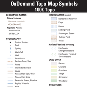
100K OnDemand Topo Cartographic Specifications - Map Symbol Guide 100K OnDemand Topo Cartographic Specifications - Map Symbol Guide
100K OnDemand Topo cartographic specifications Map Symbol Guide.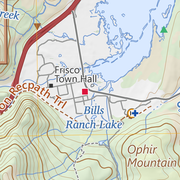
100K OnDemand Topo Cartographic Specifications 100K OnDemand Topo Cartographic Specifications
This page and associated links define the U.S. Geological Survey (USGS) 100K OnDemand Topo cartographic specifications including feature symbology and labels. The specifications are organized by data sets and themes listed within.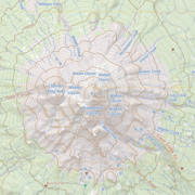
100K OnDemand Topo Cartographic Specifications - Elevation 100K OnDemand Topo Cartographic Specifications - Elevation
100K OnDemand Topo cartographic specifications including feature symbology and labels for Elevation Generated Contours and Shaded Relief.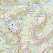
100K OnDemand Topo Cartographic Specifications - Geographic Names 100K OnDemand Topo Cartographic Specifications - Geographic Names
100K OnDemand Topo cartographic specifications including feature symbology and labels for Natural Features, Landforms, and Populated Places.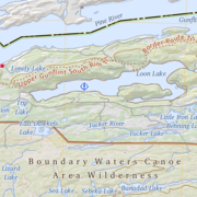
100K OnDemand Topo Cartographic Specifications - Government Units 100K OnDemand Topo Cartographic Specifications - Government Units
100K OnDemand Topo cartographic specifications including feature symbology and labels for Government Units including Counties or Equivalent, Designated Areas, Federally Managed Lands (Bureau of Land Management, Forest Service, Fish and Wildlife Service, National Park Service, and National Monuments), International, Military, National Cemetery, and State Boundaries.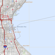
100K OnDemand Topo Cartographic Specifications - Hydrography 100K OnDemand Topo Cartographic Specifications - Hydrography
100K OnDemand Topo cartographic specifications including feature symbology and labels for Hydrography including NHDArea, NHDFlowline, NHDLine, NHDPoint, NHDWaterbody, and National Wetland Inventory.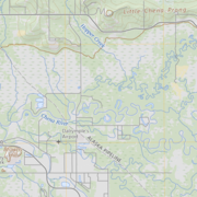
100K OnDemand Topo Cartographic Specifications - Land Cover 100K OnDemand Topo Cartographic Specifications - Land Cover
100K OnDemand Topo cartographic specifications including feature symbology and labels for Land Cover including Barren, Cropland, Grassland, Sedge, Shrubland and Woodland.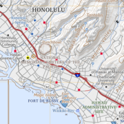
100K OnDemand Topo Cartographic Specifications - Structures 100K OnDemand Topo Cartographic Specifications - Structures
100K OnDemand Topo cartographic specifications including feature symbology and labels for Structures including Emergency Services, Medical Services, Alaska Pipeline, Public Structures and Recreation.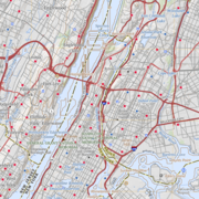
100K OnDemand Topo Cartographic Specifications - Transportation 100K OnDemand Topo Cartographic Specifications - Transportation
100K OnDemand Topo cartographic specifications including feature symbology and labels for Transportation including Airports, Railroads, Roads, and Road Shields.