
100K OnDemand Topo Cartographic Specifications - Transportation
100K OnDemand Topo cartographic specifications including feature symbology and labels for Transportation including Airports, Railroads, Roads, and Road Shields.
Transportation Feature Types
Table of Contents
Airport
Railroad
Roads
- 4WD
- Closed Road
- Expressway
- Ferry
- Highway Tunnel
- Local Connector
- Local Connector Tunnel
- Local Road
- Local Road Tunnel
- Ramp
- Secondary Highway
Road Shields
Trails
AIRPORT
Airport
Subtype of Airport
- FType: 200
- FCode: 20000
- Feature Description: An area of land or a structure used or intended to be used for the landing and takeoff of airplanes, and includes its building and facilities, if any.
- Feature Geometry: Point
Graphic Depiction
Media

Sources/Usage: Public Domain. View Media Details
- Point Graphic Depiction:
- Symbol: Airport
- Symbol Description: Dark gray airplane symbol.
- Linear Graphic Depiction: Not applicable
- Polygon Graphic Depiction: Not applicable
Point Symbology Specifications
- Layer 1 (Shape Marker: Esri Default 111)
- Size: 9.00 pt
- Color (R,G,B): 78,78,78
- Transparency: 0%
Labeling
Media

Sources/Usage: Public Domain. View Media Details
- Labeling Graphic Depiction:
- Label: Airport - Label
- Label Description: Gray text with light gray halo displaying official airport name.
- Font Style: Segoe UI, Regular
- Font Size: 7.50 pt
- Font Color (R,G,B): 78,78,78
- Font Halo Size: 0.50 pt
- Font Halo Color (R,G,B): 250,250,250
- Placement Properties: Best position; Preferred offset 4 points; Max offset 100%; Simplified symbol zones: 0, 2, 1, 3, 5, 7, 8, 6, 4, 2
Airport Runway
Subtype of Airport
- FType: 200
- FCode: 20100
- Feature Description: A designated area of water used or intended to be used for the landing and takeoff of airplanes.
- Feature Geometry: Polygon
Graphic Depiction
Media

Sources/Usage: Public Domain. View Media Details
- Point Graphic Depiction: Not applicable
- Linear Graphic Depiction: Not applicable
- Polygon Graphic Depiction:
- Symbol: Airport Runway
- Symbol Description: Gray runway polygon symbol with a gray outline and a white fill.
Point Symbology Specifications
- Layer 1 (Solid Fill)
- Size: Not applicable
- Color (R,G,B): 250,250,250
- Transparency: 0%
- Layer 2 (Solid Stroke)
- Size: 0.40 pt
- Color (R,G,B): 104,104,104
- Transparency: 0%
Labeling
Media

Sources/Usage: Public Domain. View Media Details
- Labeling Graphic Depiction:
- Label: Airport Runway - Label
- Label Description: Dark gray text with official airport or runway name.
- Font Style: Segoe UI, Regular
- Font Size: 7.50 pt
- Font Color (R,G,B): 78,78,78
- Font Halo Size: 0.50 pt
- Font Halo Color (R,G,B): 240,240,240
- Placement Properties: Regular position; Horizontal around polygon; Preferred offset 1 point, max offset 100%; Simplified symbol zones: 2, 1, 3, 5, 7, 8, 6, 4, 2
Heliport
Subtype of Airport
- FType: 200
- FCode: 20001
- Feature Description: An area of land, water, or a structure used or intended to be used for the landing and takeoff of helicopters, and includes its building and facilities, if any.
- Feature Geometry: Point
Graphic Depiction
Media

Sources/Usage: Public Domain. View Media Details
- Point Graphic Depiction:
- Symbol: Heliport
- Symbol Description: Yellow circle with a Black "H" symbol contained within. Final marker symbol size on the map is 7 points.
- Linear Graphic Depiction: Not applicable
- Polygon Graphic Depiction: Not applicable
Point Symbology Specifications
- Layer 1 (Top)
- Size: 6.00 pt
- Color (R,G,B): 0,0,0
- Transparency: 0%
- Layer 2
- Size: 19.00 pt
- Color (R,G,B): 0,0,0
- Transparency: 0%
- Layer 3
- Size: 14.00 pt
- Color (R,G,B): 230,152,0
- Transparency: 0%
- Layer 4
- Size: 16.00 pt
- Color (R,G,B): 230,152,0
- Transparency: 0%
- Layer 5
- Size: 14.00 pt
- Color (R,G,B): 230,152,0
- Transparency: 0%
- Layer 6
- Size: 16.00 pt
- Color (R,G,B): 230,152,0
- Transparency: 0%
- Layer 7 (Base)
- Size: 14.00 pt
- Color (R,G,B): 255,255,255
- Transparency: 0%
Labeling
- Labeling: Not applicable
Seaplane
Subtype of Airport
- FType: 200
- FCode: 20002
- Feature Description: A designated area of water used or intended to be used for the landing and takeoff of seaplanes and shoreside access.
- Feature Geometry: Point
Graphic Depiction
Media

Sources/Usage: Public Domain. View Media Details
- Point Graphic Depiction:
- Symbol: Seaplane
- Symbol Description: Blue seaplane symbol. Final marker symbol size on the map is 11 points.
- Linear Graphic Depiction: Not applicable
- Polygon Graphic Depiction: Not applicable
Point Symbology Specifications
- Layer 1 (Top)
- Size: 16.00 pt
- Color (R,G,B): 24,74,225
- Transparency: 0%
- Layer 2
- Size: 16.00 pt
- Color (R,G,B): 24,74,225
- Transparency: 0%
- Layer 3
- Size: 18.00 pt
- Color (R,G,B): 14,74,225
- Transparency: 0%
- Layer 4
- Size: 2.00 pt
- Color (R,G,B): 24,74,225
- Transparency: 0%
- Layer 5
- Size: 2.00 pt
- Color (R,G,B): 24,74,225
- Transparency: 0%
- Layer 6
- Size: 2.00 pt
- Color (R,G,B): 24,74,225
- Transparency: 0%
- Layer 7
- Size: 2.00 pt
- Color (R,G,B): 24,74,225
- Transparency: 0%
- Layer 8 (Base)
- Size: 14.00 pt
- Color (R,G,B): 255,255,255
- Transparency: 0%
Labeling
- Labeling: Not applicable
RAILROAD
Railroad
Subtype of Railroad
- FType: Not applicable
- FCode: Not applicable
- Feature Description: A primary railway that provides service between destinations.
- Feature Geometry: Linear
Graphic Depiction
Media

Sources/Usage: Public Domain. View Media Details
- Point Graphic Depiction: Not applicable
- Linear Graphic Depiction:
- Symbol: Railroad
- Symbol Description: Gray line with hash marks.
- Polygon Graphic Depiction: Not applicable
Line Symbology Specifications
- Layer 1 (Solid Stroke)
- Size: 1.00 pt
- Color (R,G,B): 52,52,52
- Transparency: 0%
- Layer 2 (Stroke - Dash effect: 10) (Offset Hatch: 2 points, 10 points) (Extension Effect: 2 points) (Cap Square)
- Size: 1.50 pt
- Color (R,G,B): 52,52,52
- Transparency: 0%
Labeling
- Labeling: Not applicable
ROADS
4WD
Subtype of Roads
- FType: Not applicable
- FCode: TNMFRC = 6
- Feature Description: An unpaved dirt trail where a four-wheel drive vehicle is required.
- Feature Geometry: Linear
Graphic Depiction
Media

Sources/Usage: Public Domain. View Media Details
- Point Graphic Depiction: Not applicable
- Linear Graphic Depiction:
- Symbol: 4WD
- Symbol Description: Dashed, dark gray line on top of a gray line.
- Polygon Graphic Depiction: Not applicable
Line Symbology Specifications
- Layer 1 (Stroke - Dash/Gap Pattern: 2·1)
- Size: 0.65 pt
- Color (R,G,B): 120,121,120
- Transparency: 0%
- Layer 2 (Solid Stroke)
- Size: 1.50 pt
- Color (R,G,B): 235,235,235
- Transparency: 0%
Labeling
- Labeling: Not applicable
Closed Road
Subtype of Roads
- FType: Not applicable
- FCode: TNMFRC - 9
- Feature Description: Roads that are closed.
- Feature Geometry: Linear
Graphic Depiction
Media

Sources/Usage: Public Domain. View Media Details
- Point Graphic Depiction: Not applicable
- Linear Graphic Depiction:
- Symbol: Closed Road
- Symbol Description: Light gray, dashed line over a light gray line.
- Polygon Graphic Depiction: Not applicable
Line Symbology Specifications
- Layer 1 (Stroke - Dash/Gap Pattern: 5·2)
- Size: 0.70 pt
- Color (R,G,B): 130,131,130
- Transparency: 0%
- Layer 2 (Solid Stroke)
- Size: 0.90 pt
- Color (R,G,B): 235,235,235
- Transparency: 0%
Labeling
- Labeling: Not applicable
Expressway
Subtype of Roads
- FType: Not applicable
- FCode: TNMFRC = 1
- Feature Description: Interstates and limited access highways.
- Feature Geometry: Linear
Graphic Depiction
Media

Sources/Usage: Public Domain. View Media Details
- Point Graphic Depiction: Not applicable
- Linear Graphic Depiction:
- Symbol: Expressway
- Symbol Description: Light red line with a darker red casing.
- Polygon Graphic Depiction: Not applicable
Line Symbology Specifications
- Layer 1 (Solid Stroke)
- Size: 1.50 pt
- Color (R,G,B): 175,75,76
- Transparency: 0%
- Layer 2 (Solid Stroke)
- Size: 2.25 pt
- Color (R,G,B): 130,41,41
- Transparency: 0%
Labeling
Media

Sources/Usage: Public Domain. View Media Details
- Labeling Graphic Depiction:
- Label: Expressway - Label
- Label Description: Gray text with a light gray halo displaying the road name.
- Font Style: Segoe UI, Regular, Small Caps
- Font Size: 8.00 pt
- Font Color (R,G,B): 52,52,52
- Font Halo Size: 0.50 pt
- Font Halo Color (R,G,B): 240,240,240
- Placement Properties: Street placement; Offset curved; Primary offset 1 point
Ferry
Subtype of Roads
- FType: Not applicable
- FCode: TNMFRC = 7
- Feature Description: A route that connects and maintains transportation flow over a body of water. Conveys vehicles, people, and cargo over a waterbody in a boat. Excludes commuter ferry (ferry taxis) routes and routes used by sightseeing watercraft. Spatial representation is generalized and may not accurately depict the real world location of the feature.
- Feature Geometry: Linear
Graphic Depiction
Media

Sources/Usage: Public Domain. View Media Details
- Point Graphic Depiction: Not applicable
- Linear Graphic Depiction:
- Symbol: Ferry
- Symbol Description: Gray dashed line.
- Polygon Graphic Depiction: Not applicable
Line Symbology Specifications
- Layer 1 (Stroke - Dash/Gap Pattern: 5.5·2) (Round & Miter, Miter Limit 10)
- Size: 1.00 pt
- Color (R,G,B): 155,155,155
- Transparency: 0%
Labeling
Media

Sources/Usage: Public Domain. View Media Details
- Labeling Graphic Depiction:
- Label: Ferry - Label
- Label Description: Gray text with the official ferry route name.
- Font Style: Segoe UI, Regular, Small Caps
- Font Size: 9.00 pt
- Font Color (R,G,B): 78,78,78
- Font Halo Size: 0.50 pt
- Font Halo Color (R,G,B): 240,240,240
- Placement Properties: Street placement; Offset curved; Primary offset 1 point
Highway Tunnel
Subtype of Roads
- FType: Not applicable
- FCode: TNMFRC = 8
- Feature Description: An underground passage that is open at both ends and contains a road. Connects and maintains transportation flow underneath physical or human-built obstructions, such as a mountains or rivers. Spatial representation is generalized and may not accurately depict the real world location of the feature.
- Feature Geometry: Linear
Graphic Depiction
Media

Sources/Usage: Public Domain. View Media Details
- Point Graphic Depiction: Not applicable
- Linear Graphic Depiction:
- Symbol: Highway Tunnel
- Symbol Description: Solid light red line with a light pink, dashed line overlaid on top.
- Polygon Graphic Depiction: Not applicable
Line Symbology Specifications
- Layer 1 (Stroke - Dash/Gap Pattern: 4·2)
- Size: 1.50 pt
- Color (R,G,B): 250,227,227
- Transparency: 0%
- Layer 2 (Solid Stroke)
- Size: 2.00 pt
- Color (R,G,B): 201,103,103
- Transparency: 0%
Labeling
Media

Sources/Usage: Public Domain. View Media Details
- Labeling Graphic Depiction:
- Label: Highway Tunnel - Label
- Label Description: Gray text with a light gray halo displaying the road name.
- Font Style: Segoe UI, Regular, Small Caps
- Font Size: 9.00 pt
- Font Color (R,G,B): 52,52,52
- Font Halo Size: 0.50 pt
- Font Halo Color (R,G,B): 240,240,240
- Placement Properties: Street placement; Offset curved; Primary offset 1 point
Local Connector
Subtype of Roads
- FType: Not applicable
- FCode: TNMFRC = 3
- Feature Description: Roads that collect traffic from local roads and connect smaller towns, subdivisions, and neighborhoods.
- Feature Geometry: Linear
Graphic Depiction
Media

Sources/Usage: Public Domain. View Media Details
- Point Graphic Depiction: Not applicable
- Linear Graphic Depiction:
- Symbol: Local Connector
- Symbol Description: Light gray line with a white casing.
- Polygon Graphic Depiction: Not applicable
Line Symbology Specifications
- Layer 1 (Solid Stroke)
- Size: 1.25 pt
- Color (R,G,B): 130,131,130
- Transparency: 0%
- Layer 2 (Solid Stroke)
- Size: 2.00 pt
- Color (R,G,B): 255,255,255
- Transparency: 0%
Labeling
Media
Sources/Usage: Public Domain. View Media Details
- Labeling Graphic Depiction:
- Label: Local Connector - Label
- Label Description: Gray text with a light gray halo displaying the road name.
- Font Style: Segoe UI, Regular, Small Caps
- Font Size: 9.00 pt
- Font Color (R,G,B): 52,52,52
- Font Halo Size: 0.50 pt
- Font Halo Color (R,G,B): 240,240,240
- Placement Properties: Street placement; Offset curved; Primary offset 1 point
Local Connector Tunnel
Subtype of Roads
- FType: Not applicable
- FCode: TNMFRC = 8
- Feature Description: An underground passage that is open at both ends and contains a local connector road. Connects and maintains transportation flow underneath physical or human-built obstructions, such as a mountains or rivers. Spatial representation is generalized and may not accurately depict the real world location of the feature.
- Feature Geometry: Linear
Graphic Depiction
Media

Sources/Usage: Public Domain. View Media Details
- Point Graphic Depiction: Not applicable
- Linear Graphic Depiction:
- Symbol: Local Connector Tunnel
- Symbol Description: Solid, white line base with a dashed, gray line overlaid on top.
- Polygon Graphic Depiction: Not applicable
Line Symbology Specifications
- Layer 1 (Stroke - Dash/Gap Pattern: 3·1)
- Size: 1.25 pt
- Color (R,G,B): 130,131,130
- Transparency: 0%
- Layer 2 (Solid Stroke)
- Size: 2.00 pt
- Color (R,G,B): 255,255,255
- Transparency: 0%
Labeling
Media

Sources/Usage: Public Domain. View Media Details
- Labeling Graphic Depiction:
- Label: Local Connector Tunnel - Label
- Label Description: Gray text with a light gray halo displaying the road name.
- Font Style: Segoe UI, Regular, Small Caps
- Font Size: 8.00 pt
- Font Color (R,G,B): 52,52,52
- Font Halo Size: 0.50 pt
- Font Halo Color (R,G,B): 240,240,240
- Placement Properties: Street placement; Offset curved; Primary offset 1 point
Local Road
Subtype of Roads
- FType: Not applicable
- FCode: TNMFRC = 4
- Feature Description: Generally a paved street, road, or byway that usually has a single lane of traffic in each direction.
- Feature Geometry: Linear
Graphic Depiction
Media

Sources/Usage: Public Domain. View Media Details
- Point Graphic Depiction: Not applicable
- Linear Graphic Depiction:
- Symbol: Local Road
- Symbol Description: Light gray line.
- Polygon Graphic Depiction: Not applicable
Line Symbology Specifications
- Layer 1 (Solid Stroke)
- Size: 0.80 pt
- Color (R,G,B): 150,151,150
- Transparency: 0%
Labeling
- Labeling: Not applicable
Local Road Tunnel
Subtype of Roads
- FType: Not applicable
- FCode: TNMFRC = 8
- Feature Description: An underground passage that is open at both ends and contains a local road. Connects and maintains transportation flow underneath physical or human-built obstructions, such as a mountains or rivers. Spatial representation is generalized and may not accurately depict the real world location of the feature.
- Feature Geometry: Linear
Graphic Depiction
Media

Sources/Usage: Public Domain. View Media Details
- Point Graphic Depiction: Not applicable
- Linear Graphic Depiction:
- Symbol: Local Road Tunnel
- Symbol Description: Solid, white line base with two offset dashed gray lines overlaid on top.
- Polygon Graphic Depiction: Not applicable
Line Symbology Specifications
- Layer 1 (Stroke - Dash/Gap Pattern: 2·3) (Offset Effect 0.7 point)
- Size: 0.40 pt
- Color (R,G,B): 150,151,150
- Transparency: 0%
- Layer 2 (Stroke - Dash/Gap Pattern: 2·3) (Offset Effect -0.7 point)
- Size: 0.40 pt
- Color (R,G,B): 150,151,150
- Transparency: 0%
- Layer 3 (Solid Stroke)
- Size: 1.00 pt
- Color (R,G,B): 255,255,255
- Transparency: 0%
Labeling
- Labeling: Not applicable
Ramp
Subtype of Roads
- FType: Not applicable
- FCode: TNMFRC = 5
- Feature Description: A road, sometimes called a "slip road", that typically allows controlled access from adjacent, not at-grade roads onto a limited access highway, often in the form of a cloverleaf interchange.
- Feature Geometry: Linear
Graphic Depiction
Media

Sources/Usage: Public Domain. View Media Details
- Point Graphic Depiction: Not applicable
- Linear Graphic Depiction:
- Symbol: Ramp
- Symbol Description: Light red line.
- Polygon Graphic Depiction: Not applicable
Line Symbology Specifications
- Layer 1 (Solid Stroke - Round & Miter, Miter Limit 10)
- Size: 1.00 pt
- Color (R,G,B): 201,103,103
- Transparency: 0%
Labeling
- Labeling: Not applicable
Secondary Highway
Subtype of Roads
- FType: Not applicable
- FCode: TNMFRC = 2
- Feature Description: Main arteries and highways that are not limited access, usually in the US Highway or State Highway systems.
- Feature Geometry: Linear
Graphic Depiction
Media

Sources/Usage: Public Domain. View Media Details
- Point Graphic Depiction: Not applicable
- Linear Graphic Depiction:
- Symbol: Secondary Highway
- Symbol Description: Light red line with a darker red casing.
- Polygon Graphic Depiction: Not applicable
Line Symbology Specifications
- Layer 1 (Solid Stroke)
- Size: 1.25 pt
- Color (R,G,B): 201,103,103
- Transparency: 0%
- Layer 2 (Solid Stroke)
- Size: 2.00 pt
- Color (R,G,B): 175,75,76
- Transparency: 0%
Labeling
Media

Sources/Usage: Public Domain. View Media Details
- Labeling Graphic Depiction:
- Label: Secondary Highway - Label
- Label Description: Gray text with a light gray halo displaying the road name.
- Font Style: Segoe UI, Regular, Small Caps
- Font Size: 8.00 pt
- Font Color (R,G,B): 52,52,52
- Font Halo Size: 0.50 pt
- Font Halo Color (R,G,B): 240,240,240
- Placement Properties: Street placement; Offset curved; Primary offset 1 point
ROAD SHIELDS
Interstate Route
Subtype of Road Shields
- FType: Not applicable
- FCode: Not applicable
- Feature Description: Fast, wide roads that traverse states and connect important cities. Part of the Interstate Highway System.
- Feature Geometry: Point
Graphic Depiction
Media
Sources/Usage: Public Domain. View Media Details
Media
Sources/Usage: Public Domain. View Media Details
- Point Graphic Depiction:
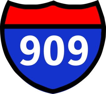
- Symbol: Interstate Route (single)
- Symbol Description: Interstate shield show in the traditional red and blue coloring with a white number contained within identifying the road segment.
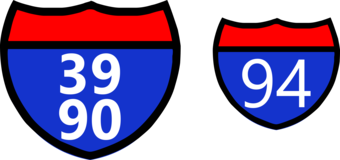
- Symbol: Interstate Route (double)
- Symbol Description: Alternate versions of the Interstate shield show in the traditional red and blue coloring with a white number contained within identifying the road segment.
- Linear Graphic Depiction: Not applicable
- Polygon Graphic Depiction: Not applicable
Point Symbology Specifications
- Layer 1 (Shape Marker: Esri Default 166)
- Size: 24.00 pt
- Color (R,G,B): 0,0,0
- Transparency: 0%
- Layer 2 (Shape Marker: Esri Default 168)
- Size: 24.00 pt
- Color (R,G,B): 40,51,204
- Transparency: 0%
- Layer 3 (Shape Marker: Esri Default 167)
- Size: 24.00 pt
- Color (R,G,B): 255,0,0
- Transparency: 0%
Labeling
Media
Sources/Usage: Public Domain. View Media Details
Media
Sources/Usage: Public Domain. View Media Details
- Labeling Graphic Depiction:
- Label: Interstate Route (single) - Label
- Label Description: Interstate shield show in the traditional red and blue coloring with a white number contained within identifying the road segment.
- Label: Interstate Route (double) - Label
- Label Description: Alternate versions of the Interstate shield show in the traditional red and blue coloring with a white number contained within identifying the road segment.
- Font Style: Segoe UI, Bold; Segoe UI, Regular
- Font Size: 5.00 pt; 6.00 pt
- Font Color (R,G,B): 255,255,255
- Font Halo Size: Not applicable
- Font Halo Color (R,G,B): Not applicable
- Placement Properties: Regular placement; Centered horizontal; Offset along line - best position
State Route
Subtype of Road Shields
- FType: Not applicable
- FCode: Not applicable
- Feature Description: Numbered routes designated and maintained by local state governments.
- Feature Geometry: Point
Media

Sources/Usage: Public Domain. View Media Details
Graphic Depiction
Media
Sources/Usage: Public Domain. View Media Details
- Point Graphic Depiction:
- Symbol: State Route (single)
- Symbol Description: State highway symbol which consists of a white circle with a black outline and a black label contained within identifying a road segment.
- Symbol: State Route (double)
- Symbol Description: Variations of the State Highway symbol: white circle with a black outline and black label contained within.
- Linear Graphic Depiction: Not applicable
- Polygon Graphic Depiction: Not applicable
Point Symbology Specifications
- Layer 1 (Shape Marker: Esri Default 171)
- Size: 22.00 pt
- Color (R,G,B): 0,0,0
- Transparency: 0%
- Layer 2 (Shape Marker: Esri Default 172)
- Size: 22.00 pt
- Color (R,G,B): 255,255,255
- Transparency: 0%
Labeling
Media
Sources/Usage: Public Domain. View Media Details
Media
Sources/Usage: Public Domain. View Media Details
- 2 images with different variations
- Labeling Graphic Depiction:
- Label: State Route (single) - Label
- Label Description: State highway symbol which consists of a white circle with a black outline and a black label identifying a road segment contained within shield symbol.
- Label: State Route (double) - Label
- Label Description: Variations of the State Highway symbol: white circle with a black outline and black label contained within shield symbol.
- Font Style: Segoe UI, Regular
- Font Size: 6.00 pt
- Font Color (R,G,B): 0,0,0
- Font Halo Size: Not applicable
- Font Halo Color (R,G,B): Not applicable
- Placement Properties: Regular placement; Centered horizontal; Offset along line - best position
US Route
Subtype of Road Shields
- FType: Not applicable
- FCode: Not applicable
- Feature Description: Also known as “US Highways,” these are numbered highways that connect populated places across the country and can sometimes be limited-access via on-ramps and off-ramps.
- Feature Geometry: Point
Graphic Depiction
Media
Sources/Usage: Public Domain. View Media Details
- Point Graphic Depiction:
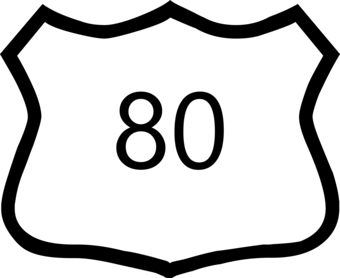
- Symbol: US Route
- Symbol Description: US Highway road shield with a black outline, white fill, and a black number contained within identifying the road segment.
- Linear Graphic Depiction: Not applicable
- Polygon Graphic Depiction: Not applicable
Point Symbology Specifications
- Layer 1 (Shape Marker: Esri Default 164)
- Size: 22.00 pt
- Color (R,G,B): 0,0,0
- Transparency: 0%
- Layer 2 (Shape Marker: Esri Default 163)
- Size: 22.00 pt
- Color (R,G,B): 255,255,255
- Transparency: 0%
Labeling
Media
Sources/Usage: Public Domain. View Media Details
- Labeling Graphic Depiction:
- Label: US Route - Label
- Label Description: US Highway road shield with a black outline, white fill, and a black number contained within identifying the road segment.
- Font Style: Segoe UI, Regular
- Font Size: 6.00 pt
- Font Color (R,G,B): 0,0,0
- Font Halo Size: Not applicable
- Font Halo Color (R,G,B): Not applicable
- Placement Properties: Regular placement; centered horizontal; Offset along line - best position
TRAILS
Standard Trail - Snow
Subtype of Trails
- FType: Not applicable
- FCode: Not applicable
- Feature Description: A trail that has a surface consisting predominantly of snow or ice and that is designed and managed to accommodate use on that surface.
- Feature Geometry: Linear
Graphic Depiction
Media

Sources/Usage: Public Domain. View Media Details
- Point Graphic Depiction: Not applicable
- Linear Graphic Depiction:
- Symbol: Standard Trail - Snow
- Symbol Description: Purple dashed line with light gray casing.
- Polygon Graphic Depiction: Not applicable
Line Symbology Specifications
- Layer 1 (Stroke - Dash/Gap Pattern: 2·2)
- Size: 0.75 pt
- Color (R,G,B): 124,81,173
- Transparency: 0%
- Layer 2 (Solid Stroke)
- Size: 1.00 pt
- Color (R,G,B): 250,250,250
- Transparency: 0%
Labeling
Media

Sources/Usage: Public Domain. View Media Details
- Labeling Graphic Depiction:
- Label: Standard Trail - Snow - Label
- Label Description: Purple text with gray halo displaying trail name.
- Font Style: Segoe UI, Semibold
- Font Size: 8.00 pt
- Font Color (R,G,B): 124,81,173
- Font Halo Size: 0.75 pt
- Font Halo Color (R,G,B): 240,240,240
- Placement Properties: Street placement; offset curved; Primary offset 1 point
Standard Trail - Terra
Subtype of Trails
- FType: Not applicable
- FCode: Not applicable
- Feature Description: A trail that has a surface consisting predominantly of the ground and that is designed and managed to accommodate use on that surface.
- Feature Geometry: Linear
Graphic Depiction
Media

Sources/Usage: Public Domain. View Media Details
- Point Graphic Depiction: Not applicable
- Linear Graphic Depiction:
- Symbol: Standard Trail - Terra
- Symbol Description: Brown dashed line with light gray casing.
- Polygon Graphic Depiction: Not applicable
Line Symbology Specifications
- Layer 1 (Stroke - Dash/Gap Pattern: 2·2)
- Size: 0.75 pt
- Color (R,G,B): 158,99,59
- Transparency: 0%
- Layer 2 (Solid Stroke)
- Size: 1.00 pt
- Color (R,G,B): 250,250,250
- Transparency: 0%
Labeling
Media

Sources/Usage: Public Domain. View Media Details
- Labeling Graphic Depiction:
- Label: Standard Trail - Terra - Label
- Label Description: Brown text with gray halo displaying trail name.
- Font Style: Segoe UI, Semibold
- Font Size: 8.00 pt
- Font Color (R,G,B): 175,82,33
- Font Halo Size: 0.75 pt
- Font Halo Color (R,G,B): 240,240,240
- Placement Properties: Street placement; offset curved; Primary offset 1 point
Standard Trail - Water
Subtype of Trails
- FType: Not applicable
- FCode: Not applicable
- Feature Description: A trail that has a surface consisting predominantly of water (but may include land-based portages) and that is designed and managed to accommodate use on that surface.
- Feature Geometry: Linear
Graphic Depiction
Media

Sources/Usage: Public Domain. View Media Details
- Point Graphic Depiction: Not applicable
- Linear Graphic Depiction:
- Symbol: Standard Trail - Water
- Symbol Description: Gray dashed line with a light blue casing.
- Polygon Graphic Depiction: Not applicable
Line Symbology Specifications
- Layer 1 (Stroke - Dash/Gap Pattern: 2·2)
- Size: 0.75 pt
- Color (R,G,B): 130,130,130
- Transparency: 0%
- Layer 2 (Solid Stroke)
- Size: 1.00 pt
- Color (R,G,B): 222,237,255
- Transparency: 0%
Labeling
Media

Sources/Usage: Public Domain. View Media Details
- Labeling Graphic Depiction:
- Label: Standard Trail - Water - Label
- Label Description: Gray text with gray halo displaying trail name.
- Font Style: Segoe UI, Semibold
- Font Size: 8.00 pt
- Font Color (R,G,B): 130,130,130
- Font Halo Size: 0.75 pt
- Font Halo Color (R,G,B): 240,240,240
- Placement Properties: Street placement; offset curved; Primary offset 1 point
Related Information
Related Information
-
100K OnDemand Topo Cartographic Specifications - Map Symbol Guide 100K OnDemand Topo Cartographic Specifications - Map Symbol Guide
100K OnDemand Topo cartographic specifications Map Symbol Guide.
100K OnDemand Topo Cartographic Specifications 100K OnDemand Topo Cartographic Specifications
This page and associated links define the U.S. Geological Survey (USGS) 100K OnDemand Topo cartographic specifications including feature symbology and labels. The specifications are organized by data sets and themes listed within.
100K OnDemand Topo Cartographic Specifications - Version History 100K OnDemand Topo Cartographic Specifications - Version History
This page highlights version history and details the refinements made to the published 100K Topo Cartographic Specifications.
100K OnDemand Topo Cartographic Specifications - Elevation 100K OnDemand Topo Cartographic Specifications - Elevation
100K OnDemand Topo cartographic specifications including feature symbology and labels for Elevation Generated Contours and Shaded Relief.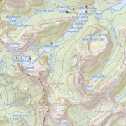
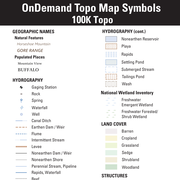
100K OnDemand Topo Cartographic Specifications - Geographic Names 100K OnDemand Topo Cartographic Specifications - Geographic Names
100K OnDemand Topo cartographic specifications including feature symbology and labels for Natural Features, Landforms, and Populated Places.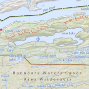
100K OnDemand Topo Cartographic Specifications - Government Units 100K OnDemand Topo Cartographic Specifications - Government Units
100K OnDemand Topo cartographic specifications including feature symbology and labels for Government Units including Counties or Equivalent, Designated Areas, Federally Managed Lands (Bureau of Land Management, Forest Service, Fish and Wildlife Service, National Park Service, and National Monuments), International, Military, National Cemetery, and State Boundaries.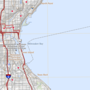
100K OnDemand Topo Cartographic Specifications - Hydrography 100K OnDemand Topo Cartographic Specifications - Hydrography
100K OnDemand Topo cartographic specifications including feature symbology and labels for Hydrography including NHDArea, NHDFlowline, NHDLine, NHDPoint, NHDWaterbody, and National Wetland Inventory.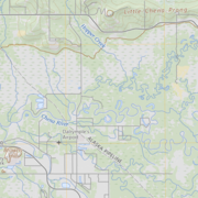
100K OnDemand Topo Cartographic Specifications - Land Cover 100K OnDemand Topo Cartographic Specifications - Land Cover
100K OnDemand Topo cartographic specifications including feature symbology and labels for Land Cover including Barren, Cropland, Grassland, Sedge, Shrubland and Woodland.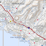
100K OnDemand Topo Cartographic Specifications - Structures 100K OnDemand Topo Cartographic Specifications - Structures
100K OnDemand Topo cartographic specifications including feature symbology and labels for Structures including Emergency Services, Medical Services, Alaska Pipeline, Public Structures and Recreation.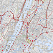
100K OnDemand Topo Cartographic Specifications - Transportation 100K OnDemand Topo Cartographic Specifications - Transportation
100K OnDemand Topo cartographic specifications including feature symbology and labels for Transportation including Airports, Railroads, Roads, and Road Shields.