
100K OnDemand Topo Cartographic Specifications - Land Cover
100K OnDemand Topo cartographic specifications including feature symbology and labels for Land Cover including Barren, Cropland, Grassland, Sedge, Shrubland and Woodland.
Land Cover Feature Types
Table of Contents
Land Cover
LAND COVER
Barren
Subtype of Land Cover
- FType: 106
- FCode: 10605
- Feature Description: Area of bedrock, desert pavement, scarps, talus, slides, volcanic material, glacial debris, sand dunes, strip mines, gravel pits and other accumulations of earthen material. Generally, vegetation accounts for less than 15% of total cover.
- Feature Geometry: Polygon
Graphic Depiction
Media

Sources/Usage: Public Domain. View Media Details
- Point Graphic Depiction: Not applicable
- Linear Graphic Depiction: Not applicable
- Polygon Graphic Depiction:
- Symbol: Barren
- Symbol Description: Light gray transparent fill.
Polygon Symbology Specifications
- Layer 1 (Simple Fill)
- Size: Not applicable
- Color (R,G,B): 211,196,201
- Transparency: 70%
Labeling
- Labeling: Not applicable
Cropland
Subtype of Land Cover
- FType: 106
- FCode: 10603
- Feature Description: Areas of grasses, legumes, or grass-legume mixtures planted for livestock grazing or the production of seed or hay crops, typically on a perennial cycle. Pasture/hay vegetation accounts for greater than 20% of total vegetation. Areas used for the production of annual crops, such as corn, soybeans, vegetables, tobacco, and cotton, and also perennial woody crops such as orchards and vineyards. Crop vegetation accounts for greater than 20% of total vegetation. This class also includes all land being actively tilled.
- Feature Geometry: Polygon
Graphic Depiction
Media

Sources/Usage: Public Domain. View Media Details
- Point Graphic Depiction: Not applicable
- Linear Graphic Depiction: Not applicable
- Polygon Graphic Depiction:
- Symbol: Cropland
- Symbol Description: Yellow transparent fill.
Polygon Symbology Specifications
- Layer 1 (Simple Fill)
- Size: Not applicable
- Color (R,G,B): 235,217,124
- Transparency: 70%
Labeling
- Labeling: Not applicable
Grassland
Subtype of Land Cover
- FType: 106
- FCode: 10604
- Feature Description: Areas dominated by graminoid or herbaceous vegetation, generally greater than 80% of total vegetation. These areas are not subject to intensive management such as tilling but can be utilized for grazing.
- Feature Geometry: Polygon
Graphic Depiction
Media

Sources/Usage: Public Domain. View Media Details
- Point Graphic Depiction: Not applicable
- Linear Graphic Depiction: Not applicable
- Polygon Graphic Depiction:
- Symbol: Grassland
- Symbol Description: Light green transparent fill.
Polygon Symbology Specifications
- Layer 1 (Simple Fill)
- Size: Not applicable
- Color (R,G,B): 200,230,124
- Transparency: 70%
Labeling
- Labeling: Not applicable
Sedge
Subtype of Land Cover
- FType: 106
- FCode: 10606
- Feature Description: Alaska-only areas dominated by sedges and forbs, generally greater than 80% of total vegetation. This type can occur with significant other grasses or other grass‑like plants, and includes sedge tundra and sedge tussock tundra.
- Feature Geometry: Polygon
Graphic Depiction
Media

Sources/Usage: Public Domain. View Media Details
- Point Graphic Depiction: Not applicable
- Linear Graphic Depiction: Not applicable
- Polygon Graphic Depiction:
- Symbol: Sedge
- Symbol Description: Dark green transparent fill.
Polygon Symbology Specifications
- Layer 1 (Simple Fill)
- Size: Not applicable
- Color (R,G,B): 168,212,180
- Transparency: 70%
Labeling
- Labeling: Not applicable
Shrubland
Subtype of Land Cover
- FType: 106
- FCode: 10602
- Feature Description: Areas dominated by shrubs; less than 5 meters tall with shrub canopy typically greater than 20% of total vegetation. This class includes true shrubs, young trees in an early successional stage or trees stunted from environmental conditions.
- Feature Geometry: Polygon
Graphic Depiction
Media

Sources/Usage: Public Domain. View Media Details
- Point Graphic Depiction: Not applicable
- Linear Graphic Depiction: Not applicable
- Polygon Graphic Depiction:
- Symbol: Shrubland
- Symbol Description: Brown transparent fill.
Polygon Symbology Specifications
- Layer 1 (Simple Fill)
- Size: Not applicable
- Color (R,G,B): 210,194,133
- Transparency: 70%
Labeling
- Labeling: Not applicable
Woodland
Subtype of Land Cover
- FType: 106
- FCode: 10601
- Feature Description: An area dominated by trees generally greater than 5 meters tall and greater than 20% of total vegetation cover. In Alaska, woodland represents an area, at least 1 acre in size, where more than 20 percent of the total vegetation cover is dominated by trees generally greater than 5 meters tall.
- Feature Geometry: Polygon
Graphic Depiction
Media

Sources/Usage: Public Domain. View Media Details
- Point Graphic Depiction: Not applicable
- Linear Graphic Depiction: Not applicable
- Polygon Graphic Depiction:
- Symbol: Woodland
- Symbol Description: Green transparent fill.
Polygon Symbology Specifications
- Layer 1 (Simple Fill)
- Size: Not applicable
- Color (R,G,B): 168,212,131
- Transparency: 70%
Labeling
- Labeling: Not applicable
Related Information
Related Information
-
100K OnDemand Topo Cartographic Specifications - Map Symbol Guide 100K OnDemand Topo Cartographic Specifications - Map Symbol Guide
100K OnDemand Topo cartographic specifications Map Symbol Guide.
100K OnDemand Topo Cartographic Specifications 100K OnDemand Topo Cartographic Specifications
This page and associated links define the U.S. Geological Survey (USGS) 100K OnDemand Topo cartographic specifications including feature symbology and labels. The specifications are organized by data sets and themes listed within.
100K OnDemand Topo Cartographic Specifications - Version History 100K OnDemand Topo Cartographic Specifications - Version History
This page highlights version history and details the refinements made to the published 100K Topo Cartographic Specifications.
100K OnDemand Topo Cartographic Specifications - Elevation 100K OnDemand Topo Cartographic Specifications - Elevation
100K OnDemand Topo cartographic specifications including feature symbology and labels for Elevation Generated Contours and Shaded Relief.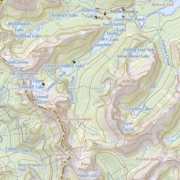
100K OnDemand Topo Cartographic Specifications - Geographic Names 100K OnDemand Topo Cartographic Specifications - Geographic Names
100K OnDemand Topo cartographic specifications including feature symbology and labels for Natural Features, Landforms, and Populated Places.
100K OnDemand Topo Cartographic Specifications - Government Units 100K OnDemand Topo Cartographic Specifications - Government Units
100K OnDemand Topo cartographic specifications including feature symbology and labels for Government Units including Counties or Equivalent, Designated Areas, Federally Managed Lands (Bureau of Land Management, Forest Service, Fish and Wildlife Service, National Park Service, and National Monuments), International, Military, National Cemetery, and State Boundaries.
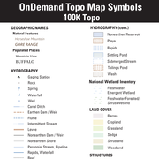
100K OnDemand Topo Cartographic Specifications - Hydrography 100K OnDemand Topo Cartographic Specifications - Hydrography
100K OnDemand Topo cartographic specifications including feature symbology and labels for Hydrography including NHDArea, NHDFlowline, NHDLine, NHDPoint, NHDWaterbody, and National Wetland Inventory.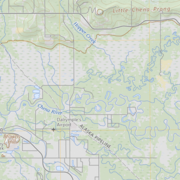
100K OnDemand Topo Cartographic Specifications - Land Cover 100K OnDemand Topo Cartographic Specifications - Land Cover
100K OnDemand Topo cartographic specifications including feature symbology and labels for Land Cover including Barren, Cropland, Grassland, Sedge, Shrubland and Woodland.
100K OnDemand Topo Cartographic Specifications - Structures 100K OnDemand Topo Cartographic Specifications - Structures
100K OnDemand Topo cartographic specifications including feature symbology and labels for Structures including Emergency Services, Medical Services, Alaska Pipeline, Public Structures and Recreation.
100K OnDemand Topo Cartographic Specifications - Transportation 100K OnDemand Topo Cartographic Specifications - Transportation
100K OnDemand Topo cartographic specifications including feature symbology and labels for Transportation including Airports, Railroads, Roads, and Road Shields.