
100K OnDemand Topo Cartographic Specifications - Structures
100K OnDemand Topo cartographic specifications including feature symbology and labels for Structures including Emergency Services, Medical Services, Alaska Pipeline, Public Structures and Recreation.
Structures Feature Type
Table of Contents
Emergency / Medical
Pipeline
Public Structures
- City–Town Hall
- College / University
- Courthouse
- Prison / Correctional Facility
- State Capitol
- State Supreme Court
- Technical College
- US Capitol
- US Supreme Court
- White House
Recreation
EMERGENCY / MEDICAL
Fire Station
Subtype of Emergency/Medical
- FType: Emergency Response and Law Enforcement
- FCode: 74026
- Feature Description: A facility housing firefighting equipment and/or personnel and a provider of emergency medical services.
- Feature Geometry: Point
Graphic Depiction
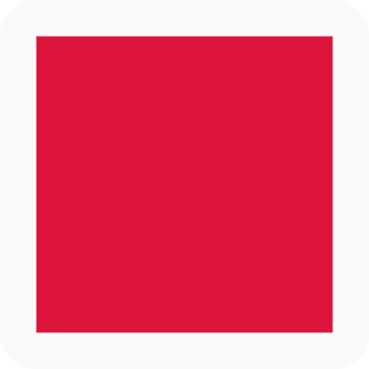
- Point Graphic Depiction:
- Symbol: Fire Station
- Symbol Description: Red square.
- Linear Graphic Depiction: Not applicable
- Polygon Graphic Depiction: Not applicable
Point Symbology Specifications
- Layer 1 (Shape Marker – Square):
- Size: 6.00 pt
- Color (R,G,B): 220,20,60
- Transparency: 0%
- Layer 2 (Halo):
- Size: 0.50 pt
- Color (R,G,B): 250,250,250
- Transparency: 0%
Labeling
- Labeling: Not applicable
Hospital
Subtype of Emergency/Medical
- FType: Health and Medical
- FCode: 80012
- Feature Description: A building or building complex providing inpatient services for medical or surgical care.
- Feature Geometry: Point
Graphic Depiction

- Point Graphic Depiction:
- Symbol: Hospital
- Symbol Description: Blue cross.
- Linear Graphic Depiction: Not applicable
- Polygon Graphic Depiction: Not applicable
Point Symbology Specifications
- Layer 1 (Shape Marker – Cross)
- Size: 6.50 pt
- Color (R,G,B): 22,81,167
- Transparency: 0%
- Layer 2 (Halo)
- Size: 0.50 pt
- Color (R,G,B): 250,250,250
- Transparency: 0%
Labeling
- Labeling: Not applicable
Law Enforcement
Subtype of Emergency/Medical
- FType: Emergency Response and Law Enforcement
- FCode: 74034
- Feature Description: A facility housing law enforcement equipment and personnel.
- Feature Geometry: Point
Graphic Depiction

- Point Graphic Depiction:
- Symbol: Law Enforcement
- Symbol Description: Blue square with a white star.
- Linear Graphic Depiction: Not applicable
- Polygon Graphic Depiction: Not applicable
Point Symbology Specifications
- Layer 1 (Shape Marker – Star)
- Size: 8.00 pt
- Color (R,G,B): 255,255,255
- Transparency: 0%
- Layer 2 (Shape Marker – Square)
- Size: 7.00 pt
- Color (R,G,B): 65,105,225
- Transparency: 0%
- Layer 3 (Halo)
- Size: 0.50 pt
- Color (R,G,B): 250,250,250
- Transparency: 0%
Labeling
- Labeling: Not applicable
PIPELINE
Oil / Gas Pipeline (Alaska only)
Subtype of Pipeline
- FType: Energy
- FCode: 75017
- Feature Description: A closed conduit for conveying oil and (or) gas over long distances located above the ground (terrain) or above the surface of a waterbody.
- Feature Geometry: Linear
Graphic Depiction

- Point Graphic Depiction: Not applicable
- Linear Graphic Depiction:
- Symbol: Oil / Gas Pipeline (Alaska only)
- Symbol Description: Solid maroon line.
- Polygon Graphic Depiction: Not applicable
Line Symbology Specifications
- Layer 1 (Solid Stroke):
- Size: 1.00 pt
- Color (R,G,B): 145,0,36
- Transparency: 0%
Labeling

- Labeling Graphic Depiction:
- Label: Oil / Gas Pipeline (Alaska only) - Label
- Label Description: Black text with a light gray halo.
- Font Style: Segoe UI, Regular
- Font Size: 9.00 pt
- Font Color (R,G,B): 52,52,52
- Font Halo Size: 0.50 pt
- Font Halo Color (R,G,B): 240,240,240
- Placement Properties: Street placement; Offset Curved; Primary Offset 1 point
PUBLIC STRUCTURES
City–Town Hall
Subtype of Public Structures
- FType: Government and Military
- FCode: 83044
- Feature Description: A building that contains the offices of the public officials of a city, town, or community.
- Feature Geometry: Point
Graphic Depiction
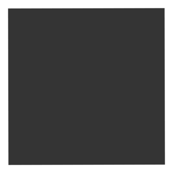
- Point Graphic Depiction:
- Symbol: City–Town Hall
- Symbol Description: Black square.
- Linear Graphic Depiction: Not applicable
- Polygon Graphic Depiction: Not applicable
Point Symbology Specifications
- Layer 1 (Shape Marker – Square)
- Size: 4.00 pt
- Color (R,G,B): 52,52,52
- Transparency: 0%
- Layer 2 (Halo)
- Size: 0.50 pt
- Color (R,G,B): 250,250,250
- Transparency: 0%
Labeling

- Labeling Graphic Depiction:
- Label: City–Town Hall - Label
- Label Description: Black text with a light gray halo.
- Font Style: Segoe UI, Regular
- Font Size: 7.00 pt
- Font Color (R,G,B): 52,52,52
- Font Halo Size: 0.50 pt
- Font Halo Color (R,G,B): 240,240,240
- Placement Properties: Best position; Preferred offset 1 point; Maximum 100%; Simplified symbol zones (Center; Then top center going clockwise): 0, 2, 1, 3, 5, 7, 8, 6, 4
College / University
Subtype of Public Structures
- FType: Education
- FCode: 73006
- Feature Description: A building or group of buildings used exclusively as an institution of higher learning that grants a degree at the completion of an extensive course of studies.
- Feature Geometry: Point
Graphic Depiction

- Point Graphic Depiction:
- Symbol: College / University
- Symbol Description: Black square.
- Linear Graphic Depiction: Not applicable
- Polygon Graphic Depiction: Not applicable
Point Symbology Specifications
- Layer 1 (Shape Marker – Square)
- Size: 4.00 pt
- Color (R,G,B): 52,52,52
- Transparency: 0%
- Layer 2 (Halo)
- Size: 0.50 pt
- Color (R,G,B): 250,250,250
- Transparency: 0%
Labeling

- Labeling Graphic Depiction:
- Label: College / University - Label
- Label Description: Black text with a light gray halo.
- Font Style: Segoe UI, Regular
- Font Size: 7.00 pt
- Font Color (R,G,B): 52,52,52
- Font Halo Size: 0.50 pt
- Font Halo Color (R,G,B): 240,240,240
- Placement Properties: Best position; Preferred offset 1 point; Maximum 100%; Simplified symbol zones (Center; Then top center going clockwise): 0, 2, 1, 3, 5, 7, 8, 6, 4
Courthouse
Subtype of Public Structures
- FType: Government and Military
- FCode: 83011
- Feature Description: A building in which courts of law are regularly held.
- Feature Geometry: Point
Graphic Depiction
- Point Graphic Depiction:
- Symbol: Courthouse
- Symbol Description: Black square.
- Linear Graphic Depiction: Not applicable
- Polygon Graphic Depiction: Not applicable
Point Symbology Specifications
- Layer 1 (Shape Marker – Square)
- Size: 4.00 pt
- Color (R,G,B): 52,52,52
- Transparency: 0%
- Layer 2 (Halo)
- Size: 0.50 pt
- Color (R,G,B): 250,250,250
- Transparency: 0%
Labeling

- Labeling Graphic Depiction:
- Label: Courthouse - Label
- Label Description: Black text with a light gray halo.
- Font Style: Segoe UI, Regular
- Font Size: 7.00 pt
- Font Color (R,G,B): 52,52,52
- Font Halo Size: 0.50 pt
- Font Halo Color (R,G,B): 240,240,240
- Placement Properties: Best position; Preferred offset 1 point; Maximum 100%; Simplified symbol zones (Center; Then top center going clockwise): 0, 2, 1, 3, 5, 7, 8, 6, 4
Prison / Correctional Facility
Subtype of Public Structures
- FType: Emergency Response and Law Enforcement
- FCode: 74036
- Feature Description: A facility for the confinement of persons convicted of crimes.
- Feature Geometry: Point
Graphic Depiction

- Point Graphic Depiction:
- Symbol: Prison / Correctional Facility
- Symbol Description: Black square with a white star.
- Linear Graphic Depiction: Not applicable
- Polygon Graphic Depiction: Not applicable
Point Symbology Specifications
- Layer 1 (Shape Marker – Star)
- Size: 8.00 pt
- Color (R,G,B): 255,255,255
- Transparency: 0%
- Layer 2 (Shape Marker – Square)
- Size: 7.00 pt
- Color (R,G,B): 52,52,52
- Transparency: 0%
- Layer 3 (Halo)
- Size: 0.50 pt
- Color (R,G,B): 250,250,250
- Transparency: 0%
Labeling
- Labeling: Not applicable
State Capitol
Subtype of Public Structures
- FType: Government and Military
- FCode: 83006
- Feature Description: A building occupied by a state legislature.
- Feature Geometry: Point
Graphic Depiction
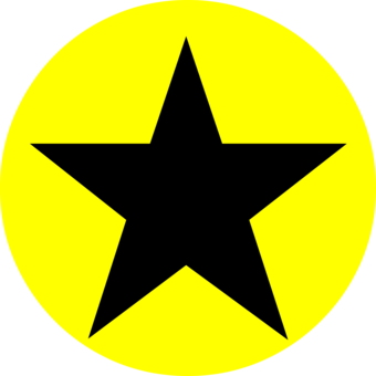
- Point Graphic Depiction:
- Symbol: State Capitol
- Symbol Description: Black star rendered on top of a yellow circle, at different offsets.
- Linear Graphic Depiction: Not applicable
- Polygon Graphic Depiction: Not applicable
Point Symbology Specifications
- Layer 1 (Shape Marker – Star)
- Size: 8.50 pt
- Color (R,G,B): 0,0,0
- Transparency: 0%
- Layer 2 (Shape Marker – Circle)
- Size: 8.50 pt
- Color (R,G,B): 255,255,0
- Transparency: 0%
Labeling

- Labeling Graphic Depiction:
- Label: State Capitol - Label
- Label Description: Black text with a light gray halo.
- Font Style: Segoe UI, Regular
- Font Size: 7.00 pt
- Font Color (R,G,B): 52,52,52
- Font Halo Size: 0.50 pt
- Font Halo Color (R,G,B): 240,240,240
- Placement Properties: Best position; Preferred offset 1 point; Maximum 100%; Simplified symbol zones (Center; Then top center going clockwise): 0, 2, 1, 3, 5, 7, 8, 6, 4
State Supreme Court
Subtype of Public Structures
- FType: Government and Military
- FCode: 83010
- Feature Description: A building that houses the highest court in the state court system.
- Feature Geometry: Point
Graphic Depiction

- Point Graphic Depiction:
- Symbol: State Supreme Court
- Symbol Description: Black square.
- Linear Graphic Depiction: Not applicable
- Polygon Graphic Depiction: Not applicable
Point Symbology Specifications
- Layer 1 (Shape Marker – Square)
- Size: 5.00 pt
- Color (R,G,B): 52,52,52
- Transparency: 0%
- Layer 2 (Halo)
- Size: 0.50 pt
- Color (R,G,B): 250,250,250
- Transparency: 0%
Labeling

- Labeling Graphic Depiction:
- Label: State Supreme Court - Label
- Label Description: Black text with a light gray halo.
- Font Style: Segoe UI, Regular
- Font Size: 7.00 pt
- Font Color (R,G,B): 52,52,52
- Font Halo Size: 0.50 pt
- Font Halo Color (R,G,B): 240,240,240
- Placement Properties: Best position; Preferred offset 1 point; Maximum 100%; Simplified symbol zones (Center; Then top center going clockwise): 0, 2, 1, 3, 5, 7, 8, 6, 4
Technical College
Subtype of Public Structures
- FType: Education
- FCode: 73007
- Feature Description: Private, state or government establishment primarily engaged in offering courses, job-specific training and (or) apprenticeships in skilled occupations often leading to job-specific certifications.
- Feature Geometry: Point
Graphic Depiction
- Point Graphic Depiction:
- Symbol: Technical College
- Symbol Description: Black square.
- Linear Graphic Depiction: Not applicable
- Polygon Graphic Depiction: Not applicable
Point Symbology Specifications
- Layer 1 (Shape Marker – Square)
- Size: 4.00 pt
- Color (R,G,B): 52,52,52
- Transparency: 0%
- Layer 2 (Halo)
- Size: 0.50 pt
- Color (R,G,B): 250,250,250
- Transparency: 0%
Labeling
- Labeling Graphic Depiction:
- Label: Technical College - Label
- Label Description: Black text with a light gray halo.
- Font Style: Segoe UI, Regular
- Font Size: 7.00 pt
- Font Color (R,G,B): 52,52,52
- Font Halo Size: 0.50 pt
- Font Halo Color (R,G,B): 240,240,240
- Placement Properties: Best position; Preferred offset 1 point; Maximum 100%; Simplified symbol zones (Center; Then top center going clockwise): 0, 2, 1, 3, 5, 7, 8, 6, 4
US Capitol
Subtype of Public Structures
- FType: Government and Military
- FCode: 83004
- Feature Description: A building occupied by the federal legislature.
- Feature Geometry: Point
Graphic Depiction
- Point Graphic Depiction:
- Symbol: US Capitol
- Symbol Description: Black star rendered on top of a yellow circle, at different offsets.
- Linear Graphic Depiction: Not applicable
- Polygon Graphic Depiction: Not applicable
Point Symbology Specifications
- Layer 1 (Shape Marker – Star)
- Size: 8.50 pt
- Color (R,G,B): 0,0,0
- Transparency: 0%
- Layer 2 (Shape Marker – Circle)
- Size: 8.50 pt
- Color (R,G,B): 255,255,0
- Transparency: 0%
Labeling
- Labeling Graphic Depiction:
- Label: US Capitol - Label
- Label Description: Black text with a light gray halo.
- Font Style: Segoe UI, Regular
- Font Size: 7.00 pt
- Font Color (R,G,B): 52,52,52
- Font Halo Size: 0.50 pt
- Font Halo Color (R,G,B): 240,240,240
- Placement Properties: Best position; Preferred offset 1 point; Maximum 100%; Simplified symbol zones (Center; Then top center going clockwise): 0, 2, 1, 3, 5, 7, 8, 6, 4
US Supreme Court
Subtype of Public Structures
- FType: Government and Military
- FCode: 83008
- Feature Description: A building that houses the Supreme Court, the highest judicial body in the United States and meets in Washington, D.C. in the United States Supreme Court Building.
- Feature Geometry: Point
Graphic Depiction
- Point Graphic Depiction:
- Symbol: US Supreme Court
- Symbol Description: Black square.
- Linear Graphic Depiction: Not applicable
- Polygon Graphic Depiction: Not applicable
Point Symbology Specifications
- Layer 1 (Shape Marker – Square)
- Size: 5.00 pt
- Color (R,G,B): 52,52,52
- Transparency: 0%
- Layer 2 (Halo)
- Size: 0.50 pt
- Color (R,G,B): 250,250,250
- Transparency: 0%
Labeling
- Labeling Graphic Depiction:
- Label: US Supreme Court - Label
- Label Description: Black text with a light gray halo.
- Font Style: Segoe UI, Regular
- Font Size: 7.00 pt
- Font Color (R,G,B): 52,52,52
- Font Halo Size: 0.50 pt
- Font Halo Color (R,G,B): 240,240,240
- Placement Properties: Best position; Preferred offset 1 point; Maximum 100%; Simplified symbol zones (Center; Then top center going clockwise): 0, 2, 1, 3, 5, 7, 8, 6, 4
White House
Subtype of Public Structures
- FType: Government and Military
- FCode: 83042
- Feature Description: The White House is both the home of the President of the United States and their family, and a living museum of American history.
- Feature Geometry: Point
Graphic Depiction
- Point Graphic Depiction:
- Symbol: White House
- Symbol Description: Black square.
- Linear Graphic Depiction: Not applicable
- Polygon Graphic Depiction: Not applicable
Point Symbology Specifications
- Layer 1 (Shape Marker – Square)
- Size: 5.00 pt
- Color (R,G,B): 52,52,52
- Transparency: 0%
- Layer 2 (Halo)
- Size: 0.50 pt
- Color (R,G,B): 250,250,250
- Transparency: 0%
Labeling
- Labeling Graphic Depiction:
- Label: White House - Label
- Label Description: Black text with a light gray halo.
- Font Style: Segoe UI, Regular
- Font Size: 7.00 pt
- Font Color (R,G,B): 52,52,52
- Font Halo Size: 0.50 pt
- Font Halo Color (R,G,B): 240,240,240
- Placement Properties: Best position; Preferred offset 1 point; Maximum 100%; Simplified symbol zones (Center; Then top center going clockwise): 0, 2, 1, 3, 5, 7, 8, 6, 4
RECREATION
Cabin
Subtype of Recreation
- FType: Public Attractions and Landmark Building
- FCode: 82007
- Feature Description: A cabin is a small house, cottage or hut, usually of primitive design and often situated in a wild or remote area. Cabins are typically isolated and have some functional significance as a shelter.
- Feature Geometry: Point
Graphic Depiction
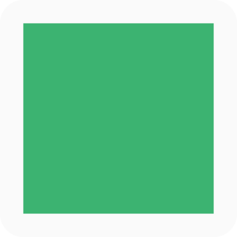
- Point Graphic Depiction:
- Symbol: Cabin
- Symbol Description: Green square.
- Linear Graphic Depiction: Not applicable
- Polygon Graphic Depiction: Not applicable
Point Symbology Specifications
- Layer 1 (Shape Marker – Square)
- Size: 7.00 pt
- Color (R,G,B): 60,179,113
- Transparency: 0%
- Layer 2 (Halo)
- Size: 0.50 pt
- Color (R,G,B): 250,250,250
- Transparency: 0%
Labeling
- Labeling: Not applicable
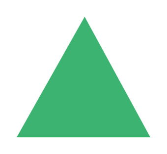
Campground
Subtype of Recreation
- FType: Public Attractions and Landmark Building
- FCode: 82008
- Feature Description: A developed, designated site for camping in tents and/or recreational vehicles.
- Feature Geometry: Point
Graphic Depiction
- Point Graphic Depiction:
- Symbol: Campground
- Symbol Description: Green triangle.
- Linear Graphic Depiction: Not applicable
- Polygon Graphic Depiction: Not applicable
Point Symbology Specifications
- Layer 1 (Shape Marker – Triangle)
- Size: 9.00 pt
- Color (R,G,B): 60,179,113
- Transparency: 0%
- Layer 2 (Halo)
- Size: 0.70 pt
- Color (R,G,B): 255,255,255
- Transparency: 0%
Labeling
- Labeling: Not applicable
Headquarters
Subtype of Recreation
- FType: Public Attractions and Landmark Building
- FCode: 83023
- Feature Description: The primary administrative office of an organization, such as the National Park Service or Forest Service, as designated by the respective organization. This is often a center of operations from which orders are issued.
- Feature Geometry: Point
Graphic Depiction

- Point Graphic Depiction:
- Symbol: Headquarters
- Symbol Description: Brown square with a triangular brown flag pointing to the right.
- Linear Graphic Depiction: Not applicable
- Polygon Graphic Depiction: Not applicable
Point Symbology Specifications
- Layer 1 (Shape Marker – Flag)
- Size: 9.00 pt
- Color (R,G,B): 102,51,0
- Transparency: 0%
- Layer 2 (Shape Marker – Square)
- Size: 5.00 pt
- Color (R,G,B): 102,51,0
- Transparency: 0%
- Layer 3 (Halo)
- Size: 0.50 pt
- Color (R,G,B): 245,240,240
- Transparency: 0%
Labeling

- Labeling Graphic Depiction:
- Label: Headquarters - Label
- Label Description: Brown text with a light gray halo.
- Font Style: Segoe UI, Regular
- Font Size: 7.00 pt
- Font Color (R,G,B): 102,51,0
- Font Halo Size: 0.50 pt
- Font Halo Color (R,G,B): 240, 240, 240
- Placement Properties: Best position; Preferred offset 1 point; Maximum 100%; Simplified symbol zones (Center; Then top center going clockwise): 0, 2, 1, 3, 5, 7, 8, 6, 4
Ranger Station
Subtype of Recreation
- FType: Public Attractions and Landmark Building
- FCode: 83033
- Feature Description: A ranger station is a small building or a portion of a larger building typically where law enforcement or emergency services are available to visitors, such as where a Park Ranger or Forest Ranger is based.
- Feature Geometry: Point
Graphic Depiction
- Point Graphic Depiction:
- Symbol: Ranger Station
- Symbol Description: Brown square with a triangular brown flag pointing to the right.
- Linear Graphic Depiction: Not applicable
- Polygon Graphic Depiction: Not applicable
Point Symbology Specifications
- Layer 1 (Shape Marker – Flag)
- Size: 9.00 pt
- Color (R,G,B): 102,51,0
- Transparency: 0%
- Layer 2 (Shape Marker – Square)
- Size: 5.00 pt
- Color (R,G,B): 102,51,0
- Transparency: 0%
- Layer 3 (Halo)
- Size: 0.50 pt
- Color (R,G,B): 245,240,240
- Transparency: 0%
Labeling
- Labeling Graphic Depiction:
- Label: Ranger Station - Label
- Label Description: Brown text with a light gray halo.
- Font Style: Segoe UI, Regular
- Font Size: 7.00 pt
- Font Color (R,G,B): 102,51,0
- Font Halo Size: 0.50 pt
- Font Halo Color (R,G,B): 240,240,240
- Placement Properties: Best position; Preferred offset 1 point; Maximum 100%; Simplified symbol zones (Center; Then top center going clockwise): 0, 2, 1, 3, 5, 7, 8, 6, 4
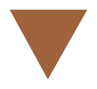
Trailhead
Subtype of Recreation
- FType: Public Attractions and Landmark Building
- FCode: 82047
- Feature Description: A designated area developed to provide transition from vehicle to foot, horse, or ATV travel. “Designated” means the responsible federal agency has marked the trailhead with ground signage, or it appears on a current and official visitor map, or is included in a GIS dataset provided by the responsible agency.
- Feature Geometry: Point
Graphic Depiction
- Point Graphic Depiction:
- Symbol: Trailhead
- Symbol Description: Inverted brown triangle.
- Linear Graphic Depiction: Not applicable
- Polygon Graphic Depiction: Not applicable
Point Symbology Specifications
- Layer 1 (Shape Marker – Triangle, Rotation -180)
- Size: 9.00 pt
- Color (R,G,B): 158,99,59
- Transparency: 0%
- Layer 2 (Halo)
- Size: 0.70 pt
- Color (R,G,B): 255,255,255
- Transparency: 0%
Labeling
- Labeling: Not applicable
Visitor Center
Subtype of Recreation
- FType: Public Attractions and Landmark Building
- FCode: 82048
- Feature Description: A building or building cluster associated with (and usually, but not always, geographically inside) a federal land unit such as a National Park or National Forest. The primary purpose of a visitor center is to serve the general public through direct contact with staff and dissemination of information about the land unit. Visitor centers commonly have educational exhibits, artifact displays, and public restroom facilities. Excludes administrative office buildings open to the public and open-air structures such as amphitheaters, observation towers, or outdoor interpretive exhibits.
- Feature Geometry: Point
Graphic Depiction

- Point Graphic Depiction:
- Symbol: Visitor Center
- Symbol Description: Brown square.
- Linear Graphic Depiction: Not applicable
- Polygon Graphic Depiction: Not applicable
Point Symbology Specifications
- Layer 1 (Shape Marker – Square)
- Size: 7.00 pt
- Color (R,G,B): 102,51,0
- Transparency: 0%
- Layer 2 (Halo)
- Size: 0.50 pt
- Color (R,G,B): 250,250,250
- Transparency: 0%
Labeling

- Labeling Graphic Depiction:
- Label: Visitor Center - Label
- Label Description: Brown text with a light gray halo.
- Font Style: Segoe UI, Regular
- Font Size: 7.00 pt
- Font Color (R,G,B): 102,51,0
- Font Halo Size: 0.50 pt
- Font Halo Color (R,G,B): 240,240,240
- Placement Properties: Best position; Preferred offset 1 point; Maximum 100%; Simplified symbol zones (Center; Then top center going clockwise): 0, 2, 1, 3, 5, 7, 8, 6, 4
Related Information
-
100K OnDemand Topo Cartographic Specifications - Map Symbol Guide 100K OnDemand Topo Cartographic Specifications - Map Symbol Guide
100K OnDemand Topo cartographic specifications Map Symbol Guide.
100K OnDemand Topo Cartographic Specifications 100K OnDemand Topo Cartographic Specifications
This page and associated links define the U.S. Geological Survey (USGS) 100K OnDemand Topo cartographic specifications including feature symbology and labels. The specifications are organized by data sets and themes listed within.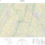
100K OnDemand Topo Cartographic Specifications - Version History 100K OnDemand Topo Cartographic Specifications - Version History
This page highlights version history and details the refinements made to the published 100K Topo Cartographic Specifications.
100K OnDemand Topo Cartographic Specifications - Elevation 100K OnDemand Topo Cartographic Specifications - Elevation
100K OnDemand Topo cartographic specifications including feature symbology and labels for Elevation Generated Contours and Shaded Relief.
100K OnDemand Topo Cartographic Specifications - Geographic Names 100K OnDemand Topo Cartographic Specifications - Geographic Names
100K OnDemand Topo cartographic specifications including feature symbology and labels for Natural Features, Landforms, and Populated Places.
100K OnDemand Topo Cartographic Specifications - Government Units 100K OnDemand Topo Cartographic Specifications - Government Units
100K OnDemand Topo cartographic specifications including feature symbology and labels for Government Units including Counties or Equivalent, Designated Areas, Federally Managed Lands (Bureau of Land Management, Forest Service, Fish and Wildlife Service, National Park Service, and National Monuments), International, Military, National Cemetery, and State Boundaries.
100K OnDemand Topo Cartographic Specifications - Hydrography 100K OnDemand Topo Cartographic Specifications - Hydrography
100K OnDemand Topo cartographic specifications including feature symbology and labels for Hydrography including NHDArea, NHDFlowline, NHDLine, NHDPoint, NHDWaterbody, and National Wetland Inventory.
100K OnDemand Topo Cartographic Specifications - Land Cover 100K OnDemand Topo Cartographic Specifications - Land Cover
100K OnDemand Topo cartographic specifications including feature symbology and labels for Land Cover including Barren, Cropland, Grassland, Sedge, Shrubland and Woodland.
100K OnDemand Topo Cartographic Specifications - Structures 100K OnDemand Topo Cartographic Specifications - Structures
100K OnDemand Topo cartographic specifications including feature symbology and labels for Structures including Emergency Services, Medical Services, Alaska Pipeline, Public Structures and Recreation.
100K OnDemand Topo Cartographic Specifications - Transportation 100K OnDemand Topo Cartographic Specifications - Transportation
100K OnDemand Topo cartographic specifications including feature symbology and labels for Transportation including Airports, Railroads, Roads, and Road Shields.