
100K OnDemand Topo Cartographic Specifications - Elevation
100K OnDemand Topo cartographic specifications including feature symbology and labels for Elevation Generated Contours and Shaded Relief.
Elevation Feature Types
Table of Contents
Contours
Shaded Relief
CONTOURS
Depression Index
Subtype of Contours
- FType: Not applicable
- FCode: 10105
- Feature Description: A line with hashes drawn on a topographic map to indicate a depression. A depression index contour is a thick, bold line, to indicate every fifth contour line.
- Feature Geometry: Linear
Graphic Depiction
Media

Sources/Usage: Public Domain. View Media Details
- Point Graphic Depiction: Not applicable
- Linear Graphic Depiction:
- Symbol: Depression Index
- Symbol Description: Brown line with ticks indicating a depression.
- Polygon Graphic Depiction: Not applicable
Line Symbology Specifications
- Layer 1 (Solid Stroke)
- Size: 0.65 pt
- Color (R,G,B): 166,116,66
- Transparency: 0%
- Layer 2 (Solid Stroke) (Offset Effect, Offset: 1.4 Points) (Offset Hatch - Length: 1.44 Points, Spacing: 5 Points)
- Size: 0.65 pt
- Color (R,G,B): 166,116,66
- Transparency: 0%
Labeling
Media

Sources/Usage: Public Domain. View Media Details
- Labeling Graphic Depiction:
- Label: Depression Index - Label
- Label Description: Brown text displaying numerical elevation value in feet.
- Font Style: Segoe UI, Italic
- Font Size: 8.00 pt
- Font Color (R,G,B): 166,116,66
- Font Halo Size: 0.50 pt
- Font Halo Color (R,G,B): 240,240,240
- Placement Properties: Regular Placement; Centered Straight; Best Position
Depression Intermediate
Subtype of Contours
- FType: Not applicable
- FCode: 10104
- Feature Description: A line drawn on a topographic map to indicate ground elevation. An intermediate contour is a thinner line between each index contour, drawn at the contour interval.
- Feature Geometry: Linear
Graphic Depiction
Media

Sources/Usage: Public Domain. View Media Details
- Point Graphic Depiction: Not applicable
- Linear Graphic Depiction:
- Symbol: Depression Intermediate
- Symbol Description: Brown line with ticks indicating a depression
- Polygon Graphic Depiction: Not applicable
Line Symbology Specifications
- Layer 1 (Solid Stroke)
- Size: 0.20 pt
- Color (R,G,B): 179,134,89
- Transparency: 0%
- Layer 2 (Solid Stroke) (Offset Effect, Offset: 1.4 Points) (Dash Effect - Dash type: 5 5) (Offset Hatch: Length: 1.44 Points, Spacing: 5 Points)
- Size: 0.20 pt
- Color (R,G,B): 179,134,89
- Transparency: 0%
Labeling
- Labeling: Not applicable
Index
Subtype of Contours
- FType: Not applicable
- FCode: 10102
- Feature Description: A line drawn on a topographic map to indicate ground elevation. An index contour is a thick, bold line, to indicate every fifth contour line and is labeled with the elevation.
- Feature Geometry: Linear
Graphic Depiction
Media

Sources/Usage: Public Domain. View Media Details
- Point Graphic Depiction: Not applicable
- Linear Graphic Depiction:
- Symbol: Index
- Symbol Description: Brown line.
- Polygon Graphic Depiction: Not applicable
Line Symbology Specifications
- Layer 1 (Solid Stroke; Round Cap: Round Join)
- Size: 0.65 pt
- Color (R,G,B): 166,116,66
- Transparency: 0%
Labeling
Media
Sources/Usage: Public Domain. View Media Details
- Labeling Graphic Depiction:
- Label: Index - Label
- Label Description: Brown text displaying numerical elevation value in feet.
- Font Style: Segoe UI, Italic
- Font Size: 8.00 pt
- Font Color (R,G,B): 166,116,66
- Font Halo Size: 0.50 pt
- Font Halo Color (R,G,B): 240,240,240
- Placement Properties: Regular Placement; Centered Straight; Best Position
Intermediate
Subtype of Contours
- FType: Not applicable
- FCode: 10101
- Feature Description: A line drawn on a topographic map to indicate ground elevation. An intermediate contour is a thinner line between each index contour, drawn at the contour interval.
- Feature Geometry: Linear
Graphic Depiction
Media

Sources/Usage: Public Domain. View Media Details
- Point Graphic Depiction: Not applicable
- Linear Graphic Depiction:
- Symbol: Intermediate
- Symbol Description: Brown line.
- Polygon Graphic Depiction: Not applicable
Line Symbology Specifications
- Layer 1 (Solid Stroke)
- Size: 0.20 pt
- Color (R,G,B): 179,134,89
- Transparency: 0%
Labeling
- Labeling: Not applicable
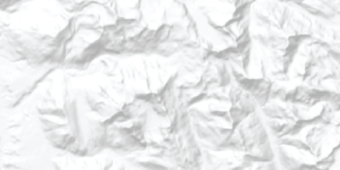
SHADED RELIEF
Shaded Relief
Subtype of Shaded Relief
- FType: Not applicable
- FCode: Not applicable
- Feature Description: Raster image depicting relief of map area.
- Feature Geometry: Image
Graphic Depiction
Media
Sources/Usage: Public Domain. View Media Details
- Point Graphic Depiction: Not applicable
- Linear Graphic Depiction: Not applicable
- Polygon Graphic Depiction: Not applicable
- Image Graphic Depiction:
- Image: Shaded Relief
- Image Description: Grayscale representation of elevation data.
Image Symbology Specifications
- Raster Image
- Size: Not applicable
- Color Space: Grayscale
- Transparency: 75%
Labeling
- Labeling: Not applicable
Related Information
Related Information
-
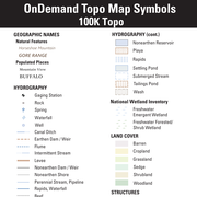
100K OnDemand Topo Cartographic Specifications - Map Symbol Guide 100K OnDemand Topo Cartographic Specifications - Map Symbol Guide
100K OnDemand Topo cartographic specifications Map Symbol Guide.
100K OnDemand Topo Cartographic Specifications 100K OnDemand Topo Cartographic Specifications
This page and associated links define the U.S. Geological Survey (USGS) 100K OnDemand Topo cartographic specifications including feature symbology and labels. The specifications are organized by data sets and themes listed within.
100K OnDemand Topo Cartographic Specifications - Version History 100K OnDemand Topo Cartographic Specifications - Version History
This page highlights version history and details the refinements made to the published 100K Topo Cartographic Specifications.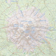
100K OnDemand Topo Cartographic Specifications - Elevation 100K OnDemand Topo Cartographic Specifications - Elevation
100K OnDemand Topo cartographic specifications including feature symbology and labels for Elevation Generated Contours and Shaded Relief.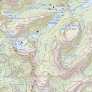
100K OnDemand Topo Cartographic Specifications - Geographic Names 100K OnDemand Topo Cartographic Specifications - Geographic Names
100K OnDemand Topo cartographic specifications including feature symbology and labels for Natural Features, Landforms, and Populated Places.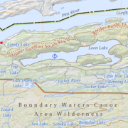
100K OnDemand Topo Cartographic Specifications - Government Units 100K OnDemand Topo Cartographic Specifications - Government Units
100K OnDemand Topo cartographic specifications including feature symbology and labels for Government Units including Counties or Equivalent, Designated Areas, Federally Managed Lands (Bureau of Land Management, Forest Service, Fish and Wildlife Service, National Park Service, and National Monuments), International, Military, National Cemetery, and State Boundaries.
100K OnDemand Topo Cartographic Specifications - Hydrography 100K OnDemand Topo Cartographic Specifications - Hydrography
100K OnDemand Topo cartographic specifications including feature symbology and labels for Hydrography including NHDArea, NHDFlowline, NHDLine, NHDPoint, NHDWaterbody, and National Wetland Inventory.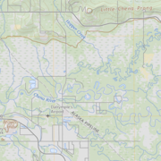
100K OnDemand Topo Cartographic Specifications - Land Cover 100K OnDemand Topo Cartographic Specifications - Land Cover
100K OnDemand Topo cartographic specifications including feature symbology and labels for Land Cover including Barren, Cropland, Grassland, Sedge, Shrubland and Woodland.
100K OnDemand Topo Cartographic Specifications - Structures 100K OnDemand Topo Cartographic Specifications - Structures
100K OnDemand Topo cartographic specifications including feature symbology and labels for Structures including Emergency Services, Medical Services, Alaska Pipeline, Public Structures and Recreation.
100K OnDemand Topo Cartographic Specifications - Transportation 100K OnDemand Topo Cartographic Specifications - Transportation
100K OnDemand Topo cartographic specifications including feature symbology and labels for Transportation including Airports, Railroads, Roads, and Road Shields.