U.S. flag

An official website of the United States government

January 11, 2023

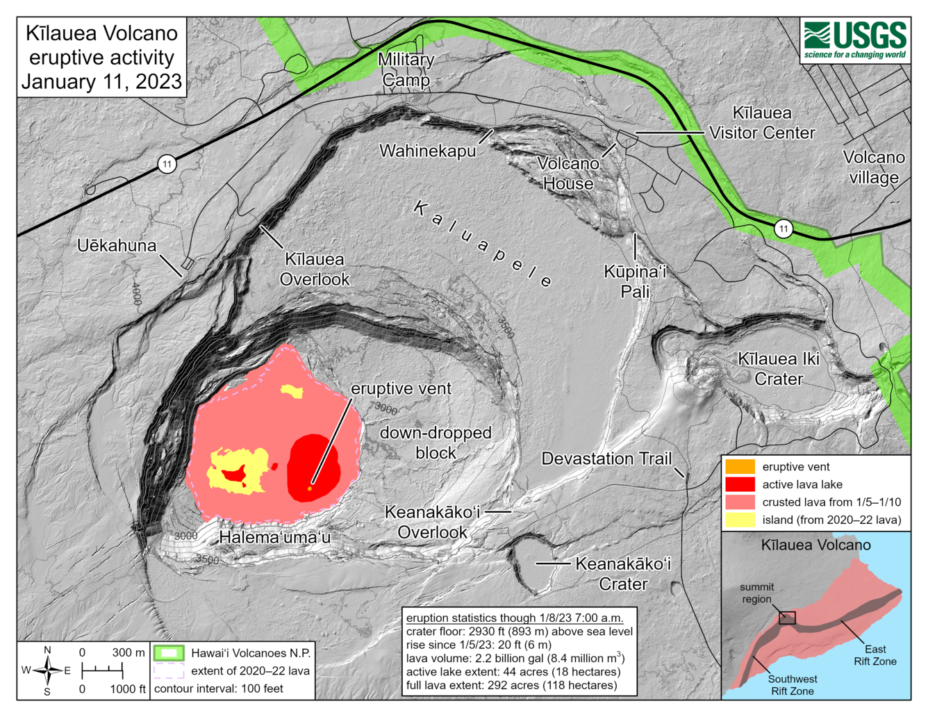
HVO scientists collect detailed data to assess hazards and understand how the eruption is evolving at Kīlauea's summit, all of which are shared with the National Park Service and emergency managers. Access to this hazardous area is by permission from, and in coordination with, Hawai‘i Volcanoes National Park. 


Color map of eruption at summit of volcano
This reference map depicts the Kīlauea summit eruption on January 11, 2023. The provided eruption statistics are derived from helicopter overflight data collected on January 8, 2023, but map features have been updated based on January 11 webcam views. One eruptive vent is active inside Halema‘uma‘u crater, within the actively circulating lava lake (red) on the eastern side of the crater floor. The extent of the active lava lake—the area in red—is 44 acres (18 hectares); part of this area is comprised of the active lava lake footprint from the end of the 2021–22 eruption, which has filled with new lava that upwelled from below. The full extent of new lava from this eruption, totaling both the active lava lake (red) and flows that have crusted over (pink) is 292 acres (118 hectares). Although this eruption has expanded the footprint of post-2018 lava within Halema‘uma‘u crater, citizen scientists may note that this full extent value is smaller than that at the end of the 2021–22 eruption: 295 acres (119 hectares). This discrepancy exists because two higher-standing sections of crater floor (yellow) have not yet been overflowed with new lava.
Color photograph of eruption
View of the continuing eruption within Halema‘uma‘u at the summit of Kīlauea at dawn looking eastwards on January 11, 2023. Lava is erupting within the southeast portion of the crater (middle) and within the basin in the western half of the crater that was the focus of activity in 2021–2022 (center bottom). The southeast portion has one dominant dome fountain, visible at bright yellow in this photo. USGS photo by N. Deligne.
Color photograph of eruption and plume
A plume emanates from the western side of Halema‘uma‘u crater, at the summit of Kīlauea, reaching the clouds of the inversion layer. The eruption within Halema‘uma‘u continues, with activity concentrated primarily in the eastern part of the crater (not shown) and a basin in the western part of the crater that was the focus of activity during the 2021-2022 eruption. Here, the western basin is characterized by some orange incandescence and a lighter gray color to the east (left) of the plume. Photo taken during an early morning overflight, with the view approximately southward. USGS photo by J.M. Chang.
Color photograph of eruption in crater
HVO geologists on an early morning helicopter overflight captured this scene of Kīlauea and Mauna Loa. The weather patterns at the time of the flight were causing the plume to stagnate and sit in Halema‘uma‘u, creating this haze shown in the caldera. Lava is still actively erupting within Halema‘uma‘u, seen here as the orange glow. USGS image by L. Gallant.
Color photograph of buildings and mountain
A view of HVO's old office building and the Jaggar Museum captured on an early morning overflight of Kīlauea summit. An inversion layer is sitting in the saddle between Kīlauea and Mauna Loa. An inversion layer forms when there is a temperature inversion of the atmosphere (warm air on top of cold air). The top layer prevents the air below it from rising, forming the distinct cloud layer shown here between Kīlauea and Mauna Loa. Mauna Kea's snow-capped summit can also be seen in the upper right of the photo. USGS image by L. Gallant.
Color map of lava lake temperature
A helicopter overflight on January 10, 2023, allowed for aerial visual and thermal imagery to be collected of Halema‘uma‘u crater at the summit of Kīlauea. The active vents are located in the eastern portion of the crater, though lava has also filled the areas previously active in the western portion of the crater. The scale of the thermal map ranges from blue to red, with blue colors indicative of cooler temperatures and red colors indicative of warmer temperatures.
Color map of lava lake temperature
A helicopter overflight on January 10, 2023, allowed for aerial visual and thermal imagery to be collected of Halema‘uma‘u crater at the summit of Kīlauea. The active vents are located in the eastern portion of the crater, though lava has also filled the areas previously active in the western portion of the crater. The scale of the thermal map ranges from blue to red, with blue colors indicative of cooler temperatures and red colors indicative of warmer temperatures. 
This video, captured by the remote B1cam, shows lava erupting from multiple minor fountains (shown as a line of bright spots in the upper left of the video) and the cooling surface of the lava forming crustal plates that move toward the camera’s location. In the lower portion of the video, you can see lava stacking up at the margin to build levees, which has created a perched lava lake within the crater. Several lava overflows of the levee are also visible during this one-day time period.
This video, captured by the KWcam, shows a large burst of lava from the newly opened vent in Halema‘uma‘u crater, Kīlauea volcano at approximately 4:49 pm HST on January 5, 2023. This burst reached up to 50 meters (164 feet) high and sent a wave of lava across the crater floor.
During the early morning hours of January 5, USGS Hawaiian Volcano Observatory scientists were closely monitoring an increase in earthquake activity and changes in the patterns of ground deformation at Kīlauea’s summit, indicating movement of magma in the subsurface. The geophysical signals intensified around 3 pm and HVO raised Kīlauea’s volcano alert level and aviation color code because an eruption was possible. The remote B1 webcam, set up to view conditions within Halema‘uma‘u crater, showed steaming and then the dramatic opening of a new vent and lava erupting onto the crater floor at 4:34 pm HST on January 5, 2023.
Kīlauea volcano began erupting in Halema‘uma‘u crater around 4:34 pm HST on January 5, 2023, as captured in this KWcam video. Within hours, multiple dome fountains were active in the central-eastern portion of Halema‘uma‘u crater’s floor. There were several large bursts of lava from the newly opened vent. One large burst up to 50 meters (164 feet) high occurred around 4:49 pm and sent a wave of lava across the crater floor. The high initial effusion rates rapidly declined as lava stored within the magma system over the past month erupted. The lava fountains decreased in vigor overnight on January 5, reaching heights of about 5 meters (16 feet). By January 8, activity focused at one dominant dome fountain, bubbling in the central-eastern portion of the active lava surface.

Get Our News

These items are in the RSS feed format (Really Simple Syndication) based on categories such as topics, locations, and more. You can install and RSS reader browser extension, software, or use a third-party service to receive immediate news updates depending on the feed that you have added. If you click the feed links below, they may look strange because they are simply XML code. An RSS reader can easily read this code and push out a notification to you when something new is posted to our site.