
Geologic map of the Wind River Range from Blackstone, 1993 (The Wind River Range, Wyoming: An Overview. Wyoming Geological Association. Jubilee Anniversary Field Conference Guidebook: Wyoming Geology, Past, Present, and Future. Pg. 121-140).
Images
Images related to Yellowstone Volcano Observatory.
Filter Total Items: 761

Geologic map of the Wind River Range, Wyoming
Geologic map of the Wind River Range from Blackstone, 1993 (The Wind River Range, Wyoming: An Overview. Wyoming Geological Association. Jubilee Anniversary Field Conference Guidebook: Wyoming Geology, Past, Present, and Future. Pg. 121-140).
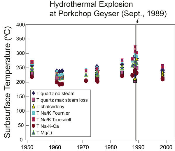
Chemical geothermometer temperatures for Porkchop Geyser, Yellowstone National Park, prior to its 1989 explosion
Chemical geothermometer temperatures for Porkchop Geyser, Yellowstone National Park, prior to its 1989 explosionFluid chemical geothermometer temperatures for Porkchop Geyser in Norris Geyser Basin, Yellowstone National Park, showing an increase of 40–60 °C (72–108 °F) for deep subsurface fluid temperatures near the time of the September 1989 Porkchop hydrothermal explosion. Note the significant scatter and variations of estimates using the conventional geothermometers.&

Deep-ocean hydrothermal vent system from the East Pacific Rise
Deep-ocean hydrothermal vent system from the East Pacific RisePhoto of a deep-ocean hydrothermal vent system from the East Pacific Rise at 9º39’N latitude and 2550 m (8366 ft) depth showing vigorously venting “black smoker” hydrothermal fluids (329 °C, or 624 °F) that are dark gray to black due to rapid precipitation of iron, copper, and zinc sulfide minerals as the hot water mixes with cold bottom waters.

Track of the Yellowstone hotspot showing the ages and locations of volcanic fields
Track of the Yellowstone hotspot showing the ages and locations of volcanic fieldsColor-shaded relief topographic map of the track of the Yellowstone hotspot showing the ages and locations of volcanic fields and faulting patterns which become younger to the northeast. Areas in cooler colors (greens and blues) represent low topographic elevations, whereas warmer colors (oranges and reds) represent high elevations. Adapted from

Porkchop Geyser erupting in August 1989
Porkchop Geyser erupting in August 1989.

Ice cone at Porkchop Geyser in March 1989
Ice cone at Porkchop Geyser in March 1989.

Apollinaris Spring, Yellowstone National Park, in 1987
Apollinaris Spring, Yellowstone National Park, in 1987Apollinaris Spring in 1987. The spring was modified in 1925 so that water would flow through pipes to be emitted from a rock wall. Yellowstone National Park photo by Jim Peaco.
Apollinaris Spring, Yellowstone National Park, in 1987
Apollinaris Spring, Yellowstone National Park, in 1987Apollinaris Spring in 1987. The spring was modified in 1925 so that water would flow through pipes to be emitted from a rock wall. Yellowstone National Park photo by Jim Peaco.
![La Garita Mountain (elevation 4179 m [13711 ft]), Colorado](https://d9-wret.s3.us-west-2.amazonaws.com/assets/palladium/production/s3fs-public/styles/masonry/public/media/images/Fig_5.32_LaGaritaMtns%20copy.jpeg?itok=G-UD0FEM)
La Garita Mountain (elevation 4179 m [13711 ft]), Colorado
La Garita Mountain (elevation 4179 m [13711 ft]), ColoradoLa Garita Mountain (elevation 4179 m [13711 ft]), Colorado. The mountain is a resurgent block of Fish Canyon Tuff that is more than 1 km (0.6 mi) thick—the top is eroded and the base is not exposed. The tuff formed during the eruption of La Garita caldera about 27.8 million years ago and has a volume of more than 5000 km3 (1200 mi3)

Mount Vesuvius behind city of Naples, Italy
Mount Vesuvius behind city of Naples. The modern cone of Vesuvius is flanked on the left by Monte Somma, the rim of a caldera that formed about 17,000 years ago. Eight major explosive eruptions have occurred since, including the 79 CE eruption that destroyed Pompeii and other towns.
Mount Vesuvius behind city of Naples. The modern cone of Vesuvius is flanked on the left by Monte Somma, the rim of a caldera that formed about 17,000 years ago. Eight major explosive eruptions have occurred since, including the 79 CE eruption that destroyed Pompeii and other towns.

Novarupta dome, Alaska
Novarupta Dome, with Falling Mountain and the upper valley portion of the Valley of Ten Thousand Smokes in the background. Photo by Tom Miller, June 1979.
Novarupta Dome, with Falling Mountain and the upper valley portion of the Valley of Ten Thousand Smokes in the background. Photo by Tom Miller, June 1979.

Muddy thermal discharge near Congress Pool in Norris Geyser Basin following the 1975 Yellowstone National Park earthquake
Muddy thermal discharge near Congress Pool in Norris Geyser Basin following the 1975 Yellowstone National Park earthquakeMuddy thermal discharge (foreground) near Congress Pool (middle ground) in Norris Geyser Basin following the June 30, 1975, magnitude-6 Yellowstone National Park earthquake, NPS photo by Rick Hutchinson.

Morning Glory Pool before and after garbage clean out, Yellowstone.
Morning Glory Pool before and after garbage clean out, Yellowstone.Morning Glory Pool used to be clear blue in color, as shown in the historic undated photo on the left (National Park Service photo by Rentchler).
Morning Glory Pool before and after garbage clean out, Yellowstone.
Morning Glory Pool before and after garbage clean out, Yellowstone.Morning Glory Pool used to be clear blue in color, as shown in the historic undated photo on the left (National Park Service photo by Rentchler).

1975 earthquake damage just south of Mammoth Hot Springs on the Mammoth-Norris highway
1975 earthquake damage just south of Mammoth Hot Springs on the Mammoth-Norris highwayPhoto of damage to the Mammoth-Norris highway, just south of Mammoth Hot Springs, caused by the June 30, 1975, magnitude-6 earthquake. Haynes Inc. photo for the Deseret News.

Gibbon River in Gibbon Meadows immediate following the 1975 Yellowstone National Park earthquake
Gibbon River in Gibbon Meadows immediate following the 1975 Yellowstone National Park earthquakeGibbon River in Gibbon Meadows immediate following the June 30, 1975, magnitude-6 Yellowstone National Park earthquake. The muddy color is due to increased sediment load. NPS photo by Rick Hutchinson.

Index map showing locations of 1967–1968 research drill holes in Yellowstone National Park
Index map showing locations of 1967–1968 research drill holes in Yellowstone National ParkMap: Index map showing locations of 1967–1968 research drill holes in Yellowstone National Park. Taken from USGS Bulletin 1967.

Generalized geologic map of the Eocene Absaroka volcanic field
Generalized geologic map of the Eocene Absaroka volcanic fieldGeneralized geologic map of the Eocene Absaroka volcanic field (modified from Smedes and Prostka, 1972 and “Geology of Wyoming”).
Generalized geologic map of the Eocene Absaroka volcanic field
Generalized geologic map of the Eocene Absaroka volcanic fieldGeneralized geologic map of the Eocene Absaroka volcanic field (modified from Smedes and Prostka, 1972 and “Geology of Wyoming”).

Correlation of Map Units chart from the Surficial Geologic Map of Yellowstone National Park
Correlation of Map Units chart from the Surficial Geologic Map of Yellowstone National ParkAn example Correlation of Map Units chart from the Surficial Geologic Map of Yellowstone National Park (U.S. Geological Survey, 1972) that demonstrates a typical classification scheme for surficial units.

Shoshone Tukudika (Sheepeater) at Medicine Lodge Creek, Idaho, in 1871
Shoshone Tukudika (Sheepeater) at Medicine Lodge Creek, Idaho, in 1871Shoshone Tukudika (Sheepeater) men, women, and children at Medicine Lodge Creek, Idaho, in 1871. This photo was taken by U.S. Geological Survey employee William Henry Jackson. Courtesy of National Park Service, Yellowstone National Park, YELL 8151.

Seismic geyser in Yellowstone’s Upper Geyser Basin during an eruption in 1969
Seismic geyser in Yellowstone’s Upper Geyser Basin during an eruption in 1969Seismic geyser in Yellowstone’s Upper Geyser Basin during an eruption. Based on the study of George Marler and USGS scientist Donald E.
Seismic geyser in Yellowstone’s Upper Geyser Basin during an eruption in 1969
Seismic geyser in Yellowstone’s Upper Geyser Basin during an eruption in 1969Seismic geyser in Yellowstone’s Upper Geyser Basin during an eruption. Based on the study of George Marler and USGS scientist Donald E.

Silicified logs of Queen's Laundry bathhouse
Silicified logs of Queen's Laundry bathhouse

Pearlette Ash in Comanche County, Kansas
Pearlette Ash in Comanche County, Kansas. Kansas Geological Survey photo by Grace Muilenburg, April 1969 (https://chasm.kgs.ku.edu/ords/pubcat.phd2.View_Photo?f_id=3165).
Pearlette Ash in Comanche County, Kansas. Kansas Geological Survey photo by Grace Muilenburg, April 1969 (https://chasm.kgs.ku.edu/ords/pubcat.phd2.View_Photo?f_id=3165).