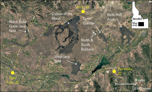
U.S. flag

An official website of the United States government

Images

Images related to Yellowstone Volcano Observatory.

Filter Total Items: 704
Map view and cross section with tightly clustered earthquakes depicting fluid-fault interaction in the Yellowstone area
Relocated Yellowstone seismicity recorded during 2008-2022

Map view of relocated Yellowstone seismicity recorded during 2008-2022, colored by time, on the left.  White line gives the outline of Yellowstone caldera. The A-A’ cross section through Yellowstone Lake is shown at the right and illustrates how seismic swarms that are distinct in time relate to one another.  Adapted from Florez and others, 2025 (

Map view of relocated Yellowstone seismicity recorded during 2008-2022, colored by time, on the left.  White line gives the outline of Yellowstone caldera. The A-A’ cross section through Yellowstone Lake is shown at the right and illustrates how seismic swarms that are distinct in time relate to one another.  Adapted from Florez and others, 2025 (

Map of Yellowstone with colored triangles and boxes showing locations, types, and operators for seismic stations
Yellowstone seismic network

Map of seismic stations in the Yellowstone region, with numbers of channels indicated by number and sensor type by color.  Inverted triangles indicate stations operated by University of Utah Seismograph Stations (UUSS), and squares indicate stations operated by other agencies.

Map of seismic stations in the Yellowstone region, with numbers of channels indicated by number and sensor type by color.  Inverted triangles indicate stations operated by University of Utah Seismograph Stations (UUSS), and squares indicate stations operated by other agencies.

A man and a woman work next to a tower with electronics equipment. Tools are scattered on the grass. Sparse trees behind.
Upgrading the WLWY continuous GPS site in Yellowstone National Park

EarthScope engineers Brendan Hodge (left) and Lia Lajoie (right) perform upgrades at the WLWY (White Lake) continuous GPS station in Yellowstone National Park.  The white box contains the receiver, while the barrel on the ground contains batteries.  The tower holds the solar panels, as well as a cellular modem and meteorological sensors that were recently

EarthScope engineers Brendan Hodge (left) and Lia Lajoie (right) perform upgrades at the WLWY (White Lake) continuous GPS station in Yellowstone National Park.  The white box contains the receiver, while the barrel on the ground contains batteries.  The tower holds the solar panels, as well as a cellular modem and meteorological sensors that were recently

Hundreds of hats laid out for display with a truck in the background providing a sense of scale
Hats collected by the Yellowstone National Park Geology Program from sensitive thermal areas in 2025

Just some of the hats collected by the Yellowstone National Park Geology Program from sensitive thermal areas throughout the park in 2025.  National Park Service photo by Margery Price, September 3, 2025.

Rock outcrop in the midst of a forest with a person standing on top collecting a sample
USGS geologist collects a sample from a potential newly recognized lava flow along the Gibbon River, Yellowstone National Park
plot showing spikes in temperature due to geyser eruptions over a 6-hour period in August 2025
Temperature record from Valentine and Guardian Geysers, Norris Geyser Basin, Yellowstone National Park, from August 24, 2025

Plot of temperatures measured by continuous loggers at Guardian Geyser (light red) and Valentine Geyser (dark red) on August 24, 2025. Activity at Guardian Geyser included episodic splashing for a few hours prior to the near-simultaneous eruptions of both geysers just after 6:30 a.m. MDT on this date.  Data collected by Mara Reed, Yellowstone National Park.

Plot of temperatures measured by continuous loggers at Guardian Geyser (light red) and Valentine Geyser (dark red) on August 24, 2025. Activity at Guardian Geyser included episodic splashing for a few hours prior to the near-simultaneous eruptions of both geysers just after 6:30 a.m. MDT on this date.  Data collected by Mara Reed, Yellowstone National Park.

Barren hillside with steaming that marks the locations of two geysers
Valentine and Guardian Geysers, Norris Geyser Basin, Yellowstone National Park

Photo of Valentine Geyser and Guardian Geyser in eruption on August 7, 2025. Valentine Geyser is in the rear of the alcove, and Guardian Geyser is at the alcove’s mouth, closer to the camera. Visitors on a trail below the Norris Geyser Basin Museum can be seen at the top of the image. Photo by Carol Beverly, used with permission.

Photo of Valentine Geyser and Guardian Geyser in eruption on August 7, 2025. Valentine Geyser is in the rear of the alcove, and Guardian Geyser is at the alcove’s mouth, closer to the camera. Visitors on a trail below the Norris Geyser Basin Museum can be seen at the top of the image. Photo by Carol Beverly, used with permission.

Color photos of the summit of Mount Rainier with snow on the mountain and clouds below.
Aerial view of the summit of Mount Rainier taken during the gas flight.

Aerial view of the summit of Mount Rainier taken during the gas flight. The photo was taken looking south, and Rainier (14,411’) rises prominently above the cloud deck at about 8,000’. Mount St. Helens (8,357’) is faintly visible in the distance.  

Aerial view of the summit of Mount Rainier taken during the gas flight. The photo was taken looking south, and Rainier (14,411’) rises prominently above the cloud deck at about 8,000’. Mount St. Helens (8,357’) is faintly visible in the distance.  

Woman in red vest standing on white terrace in front of reddish hot spring under blue sky. Mountains in the background.
Extracting wind-blown litter from a thermal feature in Yellowstone National ark

Yellowstone National Park Geology Program team member Mara Reed uses a long grabber pole to remove a park map, presumably blown from a visitor's hand or pack by the wind, from a feature in Upper Mammoth Terraces. National Park Service photo by Samantha Hilburn, August 2025.

Yellowstone National Park Geology Program team member Mara Reed uses a long grabber pole to remove a park map, presumably blown from a visitor's hand or pack by the wind, from a feature in Upper Mammoth Terraces. National Park Service photo by Samantha Hilburn, August 2025.

Woman in red vest fastens warning sign to wooden barrier. River, meadow, and forested hill in background.
Yellowstone National Park geology team installs safety signage near a hot spring

Yellowstone National Park Geology Program team member Margery Price installs a thermal danger sign near Maiden’s Grave Spring along Fountain Flat Drive. National Park Service photo by Samantha Hilburn, August 2025.

Smiling woman standing on a boardwalk and holding an open pizza box. Scrubby ground and forested hill in background.
Removing trash from Geyser Hill, Yellowstone National Park

Yellowstone National Park Geology Program volunteer Tara Cross smiles and shows off a pizza box found on Geyser Hill in Upper Geyser Basin. National Park Service photo by Margery Price, August 2025.

Yellowstone National Park Geology Program volunteer Tara Cross smiles and shows off a pizza box found on Geyser Hill in Upper Geyser Basin. National Park Service photo by Margery Price, August 2025.

Black gloved hand holding rock sample coated in green algae-like bacteria
Sample of thermophilic cyanobacteria collected from a hot spring in Yellowstone’s Lower Geyser Basin

A researcher holds a vibrant green sample of thermophilic cyanobacteria collected from a hot spring in Yellowstone’s Lower Geyser Basin. National Park Service photo by Samantha Hilburn, August 2025.

person wearing safety vest and rubber bots and gloves at the edge of a colorful hot spring scraping a bacteria sample
Sampling thermophilic cyanobacteria from a hot spring in Yellowstone's Lower Geyser Basin

A researcher collects a sample of thermophilic cyanobacteria from a hot spring in Yellowstone's Lower Geyser Basin. National Park Service photo by Samantha Hilburn, August 2025.

blue-water hot spring with a geyser to one side, forest in background, and storm clouds in the distance
Imperial Geyser in eruption, Yellowstone National Park

Imperial Geyser in eruption.  The geyser, which apparently formed in 1927, is located in Lower Geyser Basin, Yellowstone National Park.

GPS antenna with gray dome on rock in middle ground, solar panels and satellite antenna in foreground, in grassy meadow
GPS station P712 near the northwest corner of Yellowstone National Park

GPS station P712 near the northwest corner of Yellowstone National Park. The gray dome on the left is the GPS antenna, the electronics are located in the brown boxes, and the small gray dome on the right is the satellite antenna used to transmit data to the online archive for processing and analysis. Photo by Scott Johnson, EarthScope Consortium, July 30, 2025.

GPS station P712 near the northwest corner of Yellowstone National Park. The gray dome on the left is the GPS antenna, the electronics are located in the brown boxes, and the small gray dome on the right is the satellite antenna used to transmit data to the online archive for processing and analysis. Photo by Scott Johnson, EarthScope Consortium, July 30, 2025.

Ribbon-like waterfall on a gray cliff with a few trees and a splash pool in the foreground
Fairy Falls, Yellowstone National Park

Fairy Falls, a 200-foot-high (60 meters) waterfall over rhyolite cliffs in the Lower Geyser Basin of Yellowstone National Park.

Fairy Falls, a 200-foot-high (60 meters) waterfall over rhyolite cliffs in the Lower Geyser Basin of Yellowstone National Park.

fist-sized rock samples gray in color with red circles noting large white mineral grains
Samples of Lava Creek Tuff (Yellowstone caldera) with quartz and sanidine crystals indicated

Samples of Lava Creek Tuff, which erupted during the formation of Yellowstone Caldera about 631,000 years ago, with large quartz and sanidine crystals circled in red. Photos by Faith Nolander, July 22, 2025.

Microscope view of beige irregular and broken crystal surrounded by gray material. Chemical composition given for one point.
Microscope view of a sanidine crystal from the Lava Creek Tuff (Yellowstone caldera) with geochemical composition indicated for a point measured by electron microprobe analysis

A close-up (microscope) image of a sanidine crystal from the Lava Creek Tuff, which erupted during the formation of Yellowstone Caldera about 631,000 years ago, marked with a point where electron microprobe analysis was performed. The chemistry of that point is given, where each major element has a corresponding weight percent.

Map view and time series plots of deformation in the Yellowstone area
Ground deformation in the Yellowstone area from GPS viewed in a reference frame where North American plate motion has been removed
Plots of ground deformation showing the impacts of reference frame (e.g., point of view)
GPS station velocities in the western USA shown in global and North American reference frames

GPS station velocities in the western USA shown in a global (left) and North American (right) reference frame. The direction and length of each arrow shows where that station is moving over time, and how fast. The global reference frame shows overall motion of the North American plate.

GPS station velocities in the western USA shown in a global (left) and North American (right) reference frame. The direction and length of each arrow shows where that station is moving over time, and how fast. The global reference frame shows overall motion of the North American plate.

A young man and young woman examine a tan-colored rock outcrop with some grasses and a small tree
Montana State University researchers recording data at an outcrop in Yellowstone National Park

Montana State University researchers recording data at an outcrop in Yellowstone National Park. M.S. student Liv Wheeler (right) overlays the GPS position of the outcrop over a geologic map produced by USGS geologist Robert Christianson, while undergraduate student Liam Arnold (left) notes other data related to the outcrop.

Montana State University researchers recording data at an outcrop in Yellowstone National Park. M.S. student Liv Wheeler (right) overlays the GPS position of the outcrop over a geologic map produced by USGS geologist Robert Christianson, while undergraduate student Liam Arnold (left) notes other data related to the outcrop.

Was this page helpful?