
Yellowstone earthquakes that are related to ground deformation
We know that Yellowstone is an active volcanic system due to the high rate of seismicity and the active ground deformation. What happens when those two things are happening simultaneously, like they are right now?
Yellowstone Caldera Chronicles is a weekly column written by scientists and collaborators of the Yellowstone Volcano Observatory. This week's contribution is from Jamie Farrell, associate research professor with the University of Utah Seismograph Stations and Chief Seismologist of the Yellowstone Volcano Observatory.
It is well-known that the Yellowstone region, with an average of 1,500-2,500 earthquakes per year and active ground deformation, is an active volcanic area. We often talk about whether the Yellowstone Caldera or Norris Geyser Basin area is uplifting or subsiding. We also tend to focus on large earthquake swarms when they occur in the Yellowstone region. However, sometimes these two things occur at the same time and in the same area, and they are clearly related to one another. When this happens, scientists who are charged with monitoring Yellowstone must try to figure out why this is happening and what it means in terms of geologic hazards and risks to those living in and visiting the area.
So let’s look at recent episodes where seismicity and ground deformation were happening at the same place and the same time. In late December 2008, a large earthquake swarm occurred beneath northern Yellowstone Lake. The swarm started under Stevenson Island and over a ten-day period migrated north to near the outlet of Yellowstone Lake at Fishing Bridge. As the swarm passed by the Lake Lodge and housing area, where GPS station LKWY is located, the ground there moved about 7 mm (around 1/3 of an inch) to the west. This indicates that the earthquake swarm was probably due to pressurized fluids migrating to the north. There’s no clear consensus on what these fluids were, but they were most likely aqueous or gaseous fluids that came from the upper-crustal magma reservoir. The earthquakes were caused by breaking rock, and as the crack opened, it pushed the ground out of the way, resulting in the ground deformation.
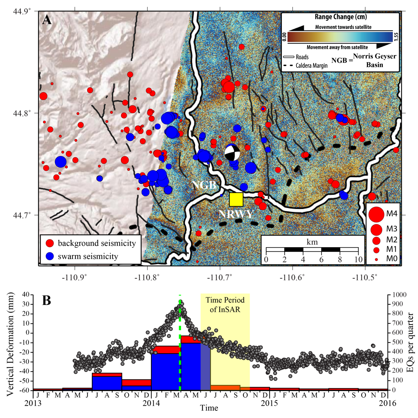
Another example is from November 2013, when the area around Norris Geyser Basin started to uplift, as recorded at nearby GPS station NRWY. Rates of uplift exceeded 15 cm/yr (~6 inches/yr), which is one of the fastest deformation rates ever recorded in Yellowstone. At around the same time and in the same area, the rate of seismicity increased. This continued into 2014 and culminated on March 30, when a M4.8 earthquake occurred near Norris Geyser Basin. This was the largest magnitude earthquake to occur in Yellowstone since 1975. Coincidentally with the M4.8 earthquake, the deformation pattern changed from uplift to rapid subsidence. This activity was interpreted as due to the accumulation and subsequent release of hydrothermal fluids beneath the geyser basin—fluids that might have come from a deeper magmatic intrusion just south of the area in 1996–2004.
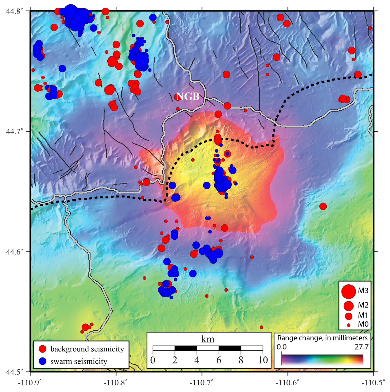
The same link between ground deformation and earthquakes is also on display right now. In July 2025, the area to the south of Norris Geyser Basin began to uplift once more. This area is located on the north rim of Yellowstone Caldera in the same place as the earlier area of deformation from 1996–2004. And there are indications of increased seismicity in the uplift area, including a swarm that occurred directly on top of the center of uplift in November 2025. At this point, there is no way of knowing what will come of this current deformation episode. Will it lead to more seismicity, larger magnitude earthquakes, or ultimately shallow accumulations of hydrothermal fluids, as apparently happened as a result of the 1996–2004 deformation episode? Although there are no clear answers at this point, YVO scientists will keep monitoring this deformation and the associated seismicity. You can follow along—the most recent deformation and seismic data are posted at https://www.usgs.gov/observatories/yvo/science/uplift-along-north-rim-yellowstone-caldera.
And watch for future Caldera Chronicles articles as this latest fascinating episode of seismicity and deformation in Yellowstone unfolds. It is very unlikely to lead to any sort of volcanic eruption (there would be a lot of changes before that would become possible!), but it will definitely teach YVO scientists new lessons about how Yellowstone works!