
Young mountains, old rocks: A geological overview of the Teton range
The Teton Range, just south of Yellowstone National Park, is the youngest mountain range in the Rockies, and possibly North America. The forces that built (and are still actively building) the Tetons differ fundamentally from those that formed the other mountain ranges in the Greater Yellowstone Ecosystem.
Yellowstone Caldera Chronicles is a weekly column written by scientists and collaborators of the Yellowstone Volcano Observatory. This week's contribution is from Stanley Mordensky, geologist with the U.S. Geological Survey.

Similar to the nearby Wind River, Beartooth, and Gallatin mountains, the formation of the oldest rocks in the Tetons dates to more than 2.7 billion years ago. At that time, a sea occupied the area where the Teton Mountains are today. Sediment accumulated in that sea before the collision of tectonic plates pushed this material at least 5–10 miles beneath the surface. At these depths, heat (up to 1000 °F, or 540 °C) and pressure (roughly 1600 times that of the atmospheric pressure on the Earth’s surface) caused the rocks to flow like soft taffy and to recrystallize, forming new minerals like garnet from the preexisting minerals. In other words, the heat and pressure metamorphosed the marine sediments into gneiss, a rock with banding of light and dark minerals and that can be found along the trail to Inspiration Point in Grand Teton National Park.
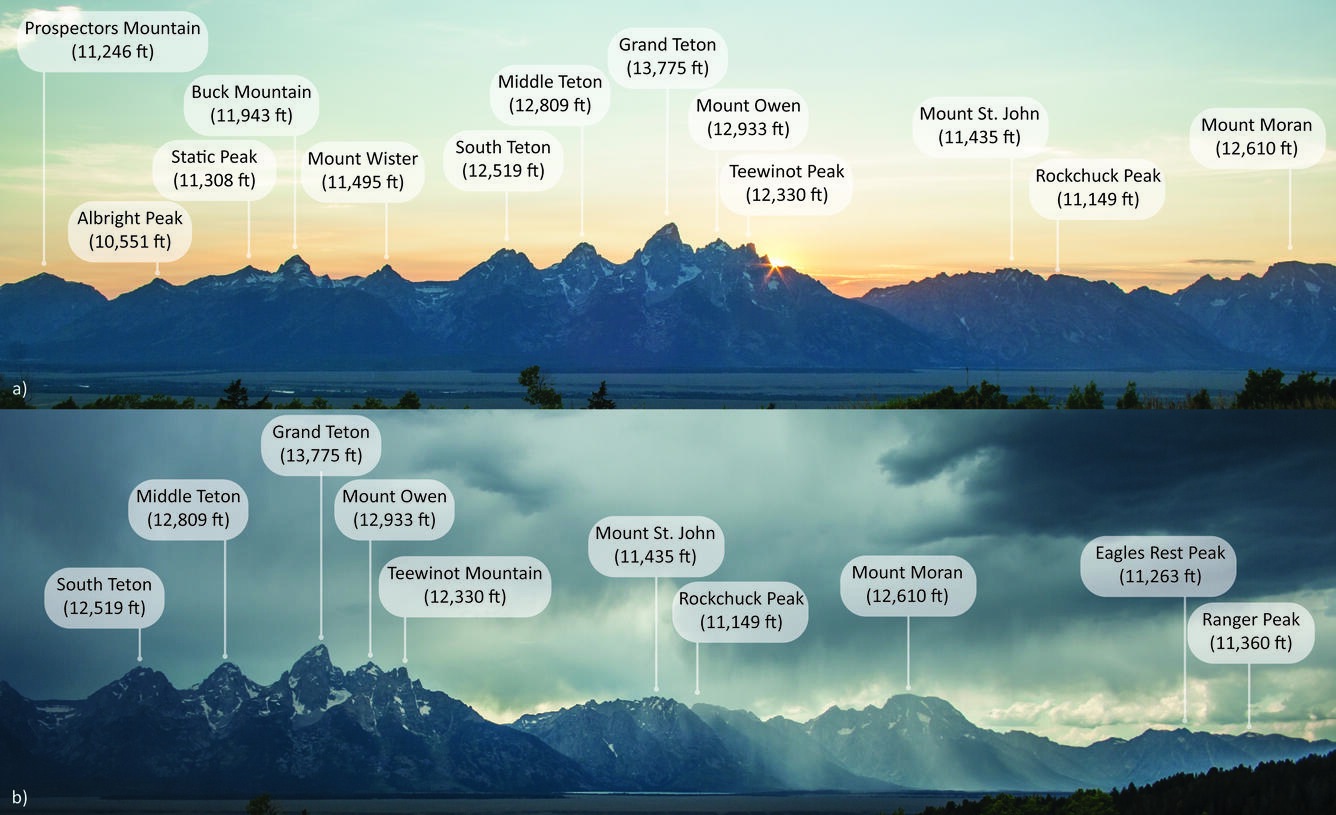
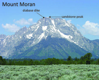
About 2.5 billion years ago, while the metamorphosed rocks remained deep below the Earth’s surface, magma worked its way through cracks and cooled, forming granite that would eventually define several of the Tetons’ high peaks (Grand Teton, Middle Teton, Mount Owen, Teewinot Mountain, and Mount Moran). Later, sometime between 1.3 billion years and 775 million years ago, additional magma intruded during a period of crustal extension. The newer magma was mafic (like basalt in terms of its composition) and formed the dark diabase dikes seen cutting through present-day Mount Moran, Middle Teton, and Grand Teton.
Just like with other mountain ranges in the Yellowstone region, the area that is now the Tetons cycled between shallow inland seas and tropical floodplains from approximately 540 to 65 million years ago. These environments left behind white beach sands (now sandstone), limestone, and mudstone rich with fossils (for example, trilobites, corals, and shells). Most of these layers have since been eroded from the high terrain of the Teton mountains, but small remnants can still be found at high elevation—for example, a small sandstone outcrop near the summit of Mount Moran.
During this time, tectonic activity was reshaping the Earth’s surface. The Farallon Plate began subducting beneath the North American Plate roughly 160 million years ago and drove the Laramide Orogeny, which is a period of mountain building in western North America that started around 80 to 70 million years ago and lasted until about 55 to 35 million years ago and uplifted many of the mountain ranges around the Greater Yellowstone Ecosystem, predominantly through reverse faulting. The block of crust that would eventually form the Tetons also experienced some Laramide uplift. Although this uplift contributed to much of why the center of the Teton Range stands as slightly higher than its northern and southern extents today, the Laramide uplift is not responsible for the majority of the vertical offset we see between the modern Tetons and Jackson Hole, WY.
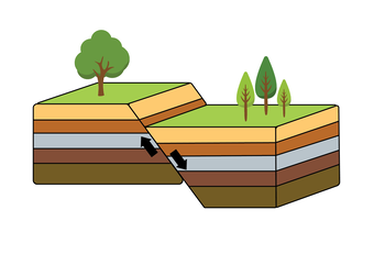
Starting around 10 million years ago, the Tetons entered a new stage of mountain building. This time, the tectonic forces were extensional rather than compressional and were related to a large geologic province in western North America called the Basin and Range, which has been undergoing tectonic extension for roughly the last 20 million years. At the Earth’s surface, this extension is expressed as normal faulting, in which two crustal blocks move away from each other and one block drops downward while the other rebounds upward. Since it began extending in an east-west direction (forming faults and mountain ranges that run north-south), the Basin and Range has approximately doubled in size.
The most obvious expression of the normal faulting in the Teton Range is the Teton Fault, visible as the eastern face of the Teton Range. The fault runs about 44 miles (70 kilometers) north–south along the eastern base of the range. Each time the fault moves, the Teton Range is lifted upward and the valley of Jackson Hole drops downward. Since its initiation, the Teton Fault has produced more than 30,000 feet (about 5.5 miles, or 9 kilometers) of cumulative vertical offset. The long‑term average slip rate of the Teton Fault is approximately 2 mm/year, but movement occurs during discrete earthquakes rather than as continuous motion. Some past earthquakes reached magnitudes of M7.5, generating up to 10 feet )3 meters) of displacement. The most recent major earthquake on the Teton Fault occurred between about 8,000 and 4,800 years ago. Other smaller normal faults capable of generating strong earthquakes are present throughout the region.
No story of mountain building in the Greater Yellowstone Ecosystem would be complete without mention of glacial sculpting. Although young compared to nearby mountain ranges, the Tetons were also subject to glaciation during the Bull Lake (about 150,000 to 130,000 years ago) and Pinedale (22,000-14,000 years ago) glacial periods, when thick accumulations of ice carved the iconic U‑shaped valleys of the Tetons and created kettle lakes throughout the region.
The Tetons continue to grow. The tectonic forces that built the range are still active, and stress continues to build even if the Teton Fault has not experienced major movement in recorded history. Evidence of ongoing stress appears east of the Teton Range, where the Snake River does not flow down the center of its riverbed. Instead, the river flows preferentially along the western side of its banks as the extensional stress builds and the eastern block of the fault (the block underlying Jackson Hole) tilts more westward. Eventually, this stress will release, and the Tetons will move again. Seismic hazards are ever present in western North America, including in western Wyoming, so preparation for future earthquakes is key.
More information on earthquake preparedness can be found at https://www.usgs.gov/programs/earthquake-hazards/prepare.