
CGS and USGS geologists and geophysicists with National Guard and Navy personnel plan next phase of helicopter-supported field investigations on Sat., July 6, 2019 at China Lake NAWS.
All Multimedia
Access all multimedia to include images, video, audio, webcams, before-after imagery, and more. Filter and explore with filtering options to refine search.
Filter Total Items: 24926

Preparing for a Helicopter Overflight
CGS and USGS geologists and geophysicists with National Guard and Navy personnel plan next phase of helicopter-supported field investigations on Sat., July 6, 2019 at China Lake NAWS.

Preparing to Survey Searles Earthquake Scarp
USGS scientists and partners review objectives and group assignments at fault scarp site. The team will deploy seismic instruments to better observe aftershock activity from close in, and to document surface faulting.
USGS scientists and partners review objectives and group assignments at fault scarp site. The team will deploy seismic instruments to better observe aftershock activity from close in, and to document surface faulting.

Railroad Track Offsets from Searles Valley Earthquake
Railroad Track Offsets from Searles Valley EarthquakeRailroad tracks offset right-laterally by about 3 feet; southeast of Hwy. 178.
Railroad Track Offsets from Searles Valley Earthquake
Railroad Track Offsets from Searles Valley EarthquakeRailroad tracks offset right-laterally by about 3 feet; southeast of Hwy. 178.

Right-Lateral Fractures from Searles Valley Earthquake
Right-Lateral Fractures from Searles Valley EarthquakeRight-lateral slip across fractures on a hillside, with shattered ground along the surface fault rupture near Ridgecrest, CA.
Right-Lateral Fractures from Searles Valley Earthquake
Right-Lateral Fractures from Searles Valley EarthquakeRight-lateral slip across fractures on a hillside, with shattered ground along the surface fault rupture near Ridgecrest, CA.

Surveying the Searles Valley Earthquake Scarp
USGS Seismologists Alan Yong and Elizabeth Cohcran conduct field work near the main rupture between Trona and Ridgecrest California.
USGS Seismologists Alan Yong and Elizabeth Cohcran conduct field work near the main rupture between Trona and Ridgecrest California.

Don't be groover shy
The "groover" is river slang for the toilet. At every camp, the groover site is choosen to accommodate a scenic view as well as to provide its users with a modicum of privacy. At our Ledge Camp, it was easy to find groover users an incredible view, but the privacy factor was in short supply. If you're on a river trip, you can't be groover shy!
The "groover" is river slang for the toilet. At every camp, the groover site is choosen to accommodate a scenic view as well as to provide its users with a modicum of privacy. At our Ledge Camp, it was easy to find groover users an incredible view, but the privacy factor was in short supply. If you're on a river trip, you can't be groover shy!

Group photo at the Dirty Devil take out
A group photo of the 13 members of the Cataract Canyon segment of the SCREE taken at the Dirty Devil (Lake Powell) take-out. From left to right: Ben Kraushaar, Pat Kikut, Matt Cuzzocreo, Tess Harden, Rick Moscati, Erika Osborne, Jessica Flock, Jan McCool, Dan McCool, John Weisheit, Kate Hudson, Tom Minckley, and Cody Perry.
A group photo of the 13 members of the Cataract Canyon segment of the SCREE taken at the Dirty Devil (Lake Powell) take-out. From left to right: Ben Kraushaar, Pat Kikut, Matt Cuzzocreo, Tess Harden, Rick Moscati, Erika Osborne, Jessica Flock, Jan McCool, Dan McCool, John Weisheit, Kate Hudson, Tom Minckley, and Cody Perry.
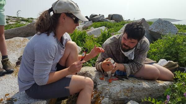
Measuring a puffin
Staudinger and masters student Keenan Yakola (UMass Amherst, 2019) measuring an adult Atlantic puffin on Seal Island National Wildlife Refuge.
Staudinger and masters student Keenan Yakola (UMass Amherst, 2019) measuring an adult Atlantic puffin on Seal Island National Wildlife Refuge.

Morning shade in Narrow Canyon
The black silhouettes of the SCREE flotilla drifts in the shadow of rock walls within Narrow Canyon of the Colorado River.
The black silhouettes of the SCREE flotilla drifts in the shadow of rock walls within Narrow Canyon of the Colorado River.

Schematic model showing a cross section of Old Faithful's plumbing
Schematic model showing a cross section of Old Faithful's plumbingSchematic model showing a cross section of Old Faithful's plumbing system as determined from seismic studies. The red circles (t0-t3) show the location of the tremor source over time, and how the tremor source migrates upward prior to an Old Faithful eruption. Times between red circles are based on a 93-minute eruption interval.

Seneca River Lake Sturgeon Release
A 59 lb., 64 in. female lake sturgeon is released into the Seneca River after telemetry tagging. Pictured GLSC (Cortland, New York) personnel are Grant Scholten, Marc Chalupnicki, and Caleb Konrad.
A 59 lb., 64 in. female lake sturgeon is released into the Seneca River after telemetry tagging. Pictured GLSC (Cortland, New York) personnel are Grant Scholten, Marc Chalupnicki, and Caleb Konrad.

Earthquake Damage on California Hwy. 178
A fault offset on California State Route 178 with a pen for scale. This measurement was conducted following the Magnitude 6.4 earthquake that struck Searles Valley on July 4, 2019.
A fault offset on California State Route 178 with a pen for scale. This measurement was conducted following the Magnitude 6.4 earthquake that struck Searles Valley on July 4, 2019.

Earthquake Damage on California Hwy. 178
California State Route 178, showing cracks due to fault offsets following the Magnitude 6.4 earthquake that struck Searles Valley on July 4, 2019.
California State Route 178, showing cracks due to fault offsets following the Magnitude 6.4 earthquake that struck Searles Valley on July 4, 2019.

Earthquake Damage on California Hwy. 178
A fault offset on California State Route 178 following the Magnitude 6.4 earthquake that struck Searles Valley on July 4, 2019.
A fault offset on California State Route 178 following the Magnitude 6.4 earthquake that struck Searles Valley on July 4, 2019.

Ledge Camp at Mile 178 of the Colorado River
The SCREE boats are tied off at a rock ledge camp along the Colorado River at Mile 178.
The SCREE boats are tied off at a rock ledge camp along the Colorado River at Mile 178.

Measuring Earthquake Damage on California Hwy. 178
Measuring Earthquake Damage on California Hwy. 178Measurement of fault offset being done by USGS scientist Ken Hudnut, using the offset of a painted road stripe. This measurement was conducted following the Magnitude 6.4 earthquake that struck Searles Valley on July 4, 2019.

Measuring Earthquake Damage on California Hwy. 178
Measuring Earthquake Damage on California Hwy. 178Measuring a fault offset on California State Route 178. This measurement was conducted following the Magnitude 6.4 earthquake that struck Searles Valley on July 4, 2019.
Measuring Earthquake Damage on California Hwy. 178
Measuring Earthquake Damage on California Hwy. 178Measuring a fault offset on California State Route 178. This measurement was conducted following the Magnitude 6.4 earthquake that struck Searles Valley on July 4, 2019.

Measuring Earthquake Damage on California Hwy. 178
Measuring Earthquake Damage on California Hwy. 178Janis Hernandez (California Geological Survey) measures 18 centimeters of offset across one strand of the fault rupture zone. This measurement was conducted following the Magnitude 6.4 earthquake that struck Searles Valley on July 4, 2019.

Measuring Earthquake Damage on California Hwy. 178
Measuring Earthquake Damage on California Hwy. 178Measurement of fault offset being done by USGS scientist Ken Hudnut, using the offset of a painted road stripe on California State Route 178. This measurement was conducted following the Magnitude 6.4 earthquake that struck Searles Valley on July 4, 2019.

Paper Powell enjoying calm waters after Cataract Canyon
Paper Powell enjoying calm waters after Cataract CanyonPaper Powell is posed in the bow of a boat relaxing upon calm waters and in the morning shade within the canyon.
Paper Powell enjoying calm waters after Cataract Canyon
Paper Powell enjoying calm waters after Cataract CanyonPaper Powell is posed in the bow of a boat relaxing upon calm waters and in the morning shade within the canyon.

Surface Rupture from Fault
On July 4, 2019, a Magnitude 6.4 earthquake struck Searles Valley, CA. This photo provides likely evidence that the fault that hosted the earthquake ruptured to the ground surface.
On July 4, 2019, a Magnitude 6.4 earthquake struck Searles Valley, CA. This photo provides likely evidence that the fault that hosted the earthquake ruptured to the ground surface.