
Ohio River at Ironton, OH - tower walkway
All Multimedia
Access all multimedia to include images, video, audio, webcams, before-after imagery, and more. Filter and explore with filtering options to refine search.
Filter Total Items: 24926

Ohio River at Ironton, OH - tower walkway

Ohio River at Ironton, OH - water quality sampler
Ohio River at Ironton, OH - water quality sampler

Ohio River at Ironton, OH - water quality sampler closeup
Ohio River at Ironton, OH - water quality sampler closeupOhio River at Ironton, OH - water quality sampler closeup
Ohio River at Ironton, OH - water quality sampler closeup
Ohio River at Ironton, OH - water quality sampler closeupOhio River at Ironton, OH - water quality sampler closeup

Ohio River at Ironton, OH - water quality sampling
Ohio River at Ironton, OH - water quality samplingOhio River at Ironton, OH - water quality sampling
Ohio River at Ironton, OH - water quality sampling
Ohio River at Ironton, OH - water quality samplingOhio River at Ironton, OH - water quality sampling

Ohio River at Ironton, OH - zebra mussels
Ohio River at Ironton, OH - staff removing zebra mussels from the equipment
Ohio River at Ironton, OH - staff removing zebra mussels from the equipment

Ohio River at Olmsted IL - damage to equipment
Ohio River at Olmsted IL - damage to equipment

Ohio River at Olmsted IL - damaged equipment
Ohio River at Olmsted IL - damaged equipment

Ohio River at Olmsted IL - equipment after cleaning
Ohio River at Olmsted IL - equipment after cleaningOhio River at Olmsted IL - equipment after cleaning
Ohio River at Olmsted IL - equipment after cleaning
Ohio River at Olmsted IL - equipment after cleaningOhio River at Olmsted IL - equipment after cleaning

Ohio River at Olmsted IL - equipment damaged by barge
Ohio River at Olmsted IL - equipment damaged by bargeOhio River at Olmsted IL - equipment damaged by barge
Ohio River at Olmsted IL - equipment damaged by barge
Ohio River at Olmsted IL - equipment damaged by bargeOhio River at Olmsted IL - equipment damaged by barge

Ohio River at Olmsted IL - equipment damaged by barge traffic
Ohio River at Olmsted IL - equipment damaged by barge trafficOhio River at Olmsted IL - equipment damaged by barge traffic
Ohio River at Olmsted IL - equipment damaged by barge traffic
Ohio River at Olmsted IL - equipment damaged by barge trafficOhio River at Olmsted IL - equipment damaged by barge traffic

Ohio River at Olmsted IL - fouled equipment
Ohio River at Olmsted IL - fouled equipment

Photographs from Canada Goose and two Bald Eagles with lead poisoning
Photographs from Canada Goose and two Bald Eagles with lead poisoningPhotographs (A &B) from a Canada Goose (Branta canadensis) found dead in Minnesota, US. (A) The esophagus is dilated and impacted with a large amount of duckweed (arrows). (B) Forty #9 lead pellets are recovered from the ventriculus. (C) Photograph from a Bald Eagle

Scientists perform postmortem examination of double-crested cormorant
Scientists perform postmortem examination of double-crested cormorantWildlife disease experts at the USGS National Wildlife Health Center in Madison, WI examine a double-crested cormorant while wearing full biosafety gear. The postmortem examination, also known as a necropsy, gives the scientists clues to what may have caused the animal to die. Examination of wild birds is important to detect pathogens that could imp

ANSEP student Jakob Sipary holds a red-throated loon, Alaska
ANSEP student Jakob Sipary holds a red-throated loon, AlaskaAlaska Native Science and Engineering Program (ANSEP) student Jakob Sipary holds a red-throated loon on the Canning River Delta, Alaska, July 2019 as part of a USGS study on loon marine habitat use areas. Jakob was an intern for the summer with the U.S. Geological Survey.

SQUID-5 - Structure-from-Motion Quantitative Underwater Imaging Device
SQUID-5 - Structure-from-Motion Quantitative Underwater Imaging DeviceThe SQUID-5, or a Structure-from-Motion (SfM) Quantitative Underwater Imaging Device with 5 cameras is a towed surface vehicle with an onboard Global Navigation Satellite System (GNSS) and 5 downward-looking cameras with overlapping views of the seafloor.

Western Toad Hops Towards Road Passage After Reaching Turn-Around
Western Toad Hops Towards Road Passage After Reaching Turn-AroundWildlife passages are one tool used to help amphibians and reptiles cross roads safely. Barrier fencing along the road and "turn-arounds" help guide these animals towards the passageways. In this video, a western toad hops back towards the passage after reaching a turn-around structure, following the barrier fencing.
")
Animation of Ridgecrest Earthquake Seq. thru July 6 (Prelim. Results)
Animation of Ridgecrest Earthquake Seq. thru July 6 (Prelim. Results)This animation shows preliminary results from precise relocation of the Ridgecrest earthquake sequence, through July 6 (UTC), including the foreshock sequence and the first ~20 hours of aftershocks from M 7.1 mainshock. The animation begins in a map view and then transitions into a rotating vertical slice. Earthquakes are colorcoded by time of occurrence
")
Animation of Ridgecrest Foreshock Seq up to M7.1 (Prelim. Results)
Animation of Ridgecrest Foreshock Seq up to M7.1 (Prelim. Results)This animation shows preliminary results from precise relocation of the Ridgecrest foreshock sequence, up to the the time of occurrence of the M 7.1 mainshock. The animation begins in a map view and then transitions into a rotating vertical slice. Earthquakes are colorcoded by time of occurrence, with early events in dark blue and later events (up to the
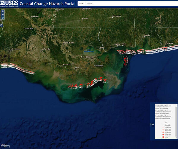
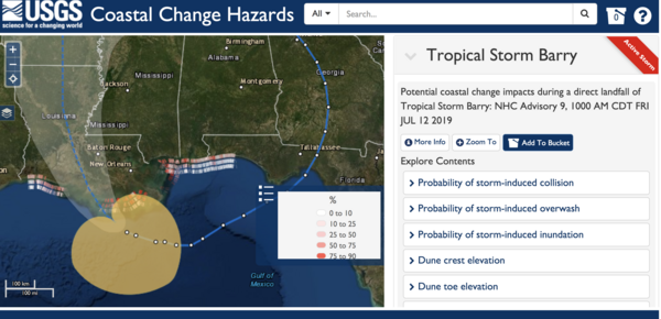
Barry's wave, surge likely to affect beaches in four states
Barry's wave, surge likely to affect beaches in four statesThis Coastal Change Storm Hazard Team map was created Friday, July 12, 2019 and shows forecast beach erosion (the strip of colored bars closest to the coast), overwash (middle strip) and inundation (outer strip) effects of Tropical Storm Barry’s predicted landfall in Louisiana.

An Arctic Tern with zooplankton
An Arctic Tern with zooplankton in Prince William Sound, Alaska.
An Arctic Tern with zooplankton in Prince William Sound, Alaska.