
The USGS Pacific Coastal and Marine Science Center's new inflatable boat equipped with a portable, single beam, shallow-water echo sounder used for nearshore surveys. USGS scientists collect such data seasonally, to study sediment input and movement in and around Monterey Bay area beaches.
All Multimedia
Access all multimedia to include images, video, audio, webcams, before-after imagery, and more. Filter and explore with filtering options to refine search.
Filter Total Items: 24923

Ready for nearshore survey
The USGS Pacific Coastal and Marine Science Center's new inflatable boat equipped with a portable, single beam, shallow-water echo sounder used for nearshore surveys. USGS scientists collect such data seasonally, to study sediment input and movement in and around Monterey Bay area beaches.
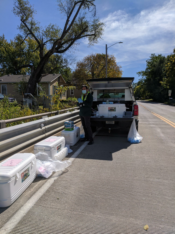
Samples collected during the red-dye study trial run in Desoto, Kansas
Samples collected during the red-dye study trial run in Desoto, KansasUSGS scientist watches over the many samples collected during the red-dye study trial run in Desoto, Kansas while he awaits the next sample.
Samples collected during the red-dye study trial run in Desoto, Kansas
Samples collected during the red-dye study trial run in Desoto, KansasUSGS scientist watches over the many samples collected during the red-dye study trial run in Desoto, Kansas while he awaits the next sample.

Panoramic view of Pocket Basin, Yellowstone National Park
Panoramic view of Pocket Basin, Yellowstone National ParkPanoramic photo of Pocket Basin, a hydrothermal explosion crater in Yellowstone National Park's Lower Geyser Basin, taken from the northeast rim looking southwest into the crater. Pocket Basin is a U-shaped crater that is dissected on the SW edge by the Firehole River, visible on the far-right of the photo.

Response of Big Sagebrush Plant Communities
Response of Big Sagebrush Plant Communities to Climate Change, Grazing, and Cheatgrass Throughout the 21st Century
Response of Big Sagebrush Plant Communities to Climate Change, Grazing, and Cheatgrass Throughout the 21st Century

USGS Testing ground-penetrating radar (GPR) on a cableway
USGS Testing ground-penetrating radar (GPR) on a cablewayIn September 2020 USGS tested ground-penetrating radar (GPR) mounted on a cableway over the Gunnison River in Colorado. USGS has been testing use of the GPR to map river bathymetry (profiles of water depth along the river), measurements often made by personnel in the water or on boats.

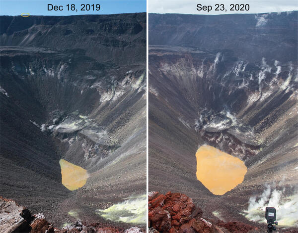
Floating material on Kīlauea's summit water lake on September 23, 2020
Floating material on Kīlauea's summit water lake on September 23, 2020Small patches of light-colored floating material were seen drifting on the surface of Kīlauea's summit water lake on September 23, 2020. The composition of this material is unknown, but future water sampling missions may provide insight. USGS photo by M. Patrick.

GSL Elephant Head
Technicians set up equipment to monitor atmospheric deposition on Elephant Head on a bluebird day, looking north across the Great Salt Lake.
Technicians set up equipment to monitor atmospheric deposition on Elephant Head on a bluebird day, looking north across the Great Salt Lake.

GSL Elephant Head 2
Spectacular view of Great Salt Lake on relatively clear day. Lake is lost in the distance as it meets the blue of the sky at the horizon. USGS research scientists in foreground setting up atmospheric deposition collection frame on Elephant Head.
Spectacular view of Great Salt Lake on relatively clear day. Lake is lost in the distance as it meets the blue of the sky at the horizon. USGS research scientists in foreground setting up atmospheric deposition collection frame on Elephant Head.

Kīlauea summit gravity survey - September 23, 2020
Kīlauea summit gravity survey - September 23, 2020A gravimeter makes a measurement at a benchmark situated among lava flows erupted in 1919. The strength of gravity varies with both elevation and the amount of mass beneath the instrument. Changes in mass can indicate changes in the amount of magma entering Kīlauea's magma reservoirs. USGS photo by A. Flinders.

Kīlauea summit gravity survey - September 23, 2020
Kīlauea summit gravity survey - September 23, 2020On September 23, 2020, Hawaiian Volcano Observatory geophysicists and a geologist conducted a gravity survey of Kīlauea summit, as part of HVO's regular monitoring program. In this photo, scientists are carrying survey equipment westward along the remnants of the Halema‘uma‘u Trail on the down-dropped block of Kīlauea caldera.

Kīlauea summit gravity survey - September 23, 2020
Kīlauea summit gravity survey - September 23, 2020During a gravity survey, HVO scientists measure the relative strength of gravity (gravimeter, bottom left corner of photo) between benchmarks. High-precision vertical positions from kinematic Global Positioning System (GPS, tripod and antenna middle of photo) help correct the gravity measurement for the effects of elevation changes.

Kīlauea summit gravity survey - September 23, 2020
Kīlauea summit gravity survey - September 23, 2020An HVO geophysicist takes a gravity measurement at a benchmark near a continuous gravimeter (inside hutch). The continuous gravimeter takes gravity measurements once per second and relays the data via radio back to HVO. During the gravity survey on September 23, 2020, HVO scientists took measurements at multiple locations on the floor of Kīlauea caldera.
Kīlauea's summit water lake comparison - September 23, 2020
Kīlauea's summit water lake comparison - September 23, 2020HVO geologists made observations of Kīlauea's summit water lake from the east rim of Halema‘uma‘u. This view point is on the large downdropped block that subsided during the 2018 collapse events. From this spot, a view of the entire lake is possible, providing a new perspective on the growth of the lake.

Kīlauea's water lake from the east side - September 23, 2020
Kīlauea's water lake from the east side - September 23, 2020This view shows Kīlauea's water lake from the east side of the crater. On September 23, 2020, the western portion of the lake (top of image) was the most varied in color, with patches of greenish and brown water. The majority of the lake surface, however, was the typical tan hue. USGS photo by M. Patrick.

Kīlauea’s summit water lake and Crater Rim Drive - September 23, 2020
Kīlauea’s summit water lake and Crater Rim Drive - September 23, 2020Portions of Crater Rim Drive, within Hawai‘i Volcanoes National Park, appear cracked, offset, and down-dropped in this photo, taken during an overflight of Kīlauea’s summit on September 23, 2020. To the north, Kīlauea’s summit water lake, within Halema‘uma‘u, is visible. USGS photo by K. Mulliken.

Low streamflow at USGS streamgage Young Womans Creek near Renovo, PA
Low streamflow at USGS streamgage Young Womans Creek near Renovo, PALow streamflow in late September, 2020 at USGS streamgage Young Womans Creek near Renovo, Pennsylvania (01545600).
Low streamflow at USGS streamgage Young Womans Creek near Renovo, PA
Low streamflow at USGS streamgage Young Womans Creek near Renovo, PALow streamflow in late September, 2020 at USGS streamgage Young Womans Creek near Renovo, Pennsylvania (01545600).

Low streamflow at USGS streamgage Young Womans Creek near Renovo, PA_2
Low streamflow at USGS streamgage Young Womans Creek near Renovo, PA_2Low streamflow in late September, 2020 at USGS streamgage Young Womans Creek near Renovo, Pennsylvania (01545600).
Low streamflow at USGS streamgage Young Womans Creek near Renovo, PA_2
Low streamflow at USGS streamgage Young Womans Creek near Renovo, PA_2Low streamflow in late September, 2020 at USGS streamgage Young Womans Creek near Renovo, Pennsylvania (01545600).

Sulphur Banks area and Ha‘akulamanu trail
Hawaiian Volcano Observatory geologists flew over the Sulphur Banks area and Ha‘akulamanu trail within Hawai‘i Volcanoes National Park on September 23, 2020. Fumaroles in the Sulphur Banks area are sampled approximately every three months by Hawaiian Volcano Observatory gas geochemists to track long-term changes in volcanic gas chemistry at Kīlauea.
Hawaiian Volcano Observatory geologists flew over the Sulphur Banks area and Ha‘akulamanu trail within Hawai‘i Volcanoes National Park on September 23, 2020. Fumaroles in the Sulphur Banks area are sampled approximately every three months by Hawaiian Volcano Observatory gas geochemists to track long-term changes in volcanic gas chemistry at Kīlauea.

Video of the water lake at Kīlauea's summit
This video, taken on September 23, 2020, shows a small area of bubbling or upwelling along the western shoreline of the water lake at the summit of Kīlauea. This feature may result from a submerged fumarole (gas vent) on the crater wall. The extent of this feature is limited and it does not seem to have a significant effect on the overall lake surface activity.
This video, taken on September 23, 2020, shows a small area of bubbling or upwelling along the western shoreline of the water lake at the summit of Kīlauea. This feature may result from a submerged fumarole (gas vent) on the crater wall. The extent of this feature is limited and it does not seem to have a significant effect on the overall lake surface activity.

Views of Kīlauea's growing summit water lake
A helicopter overflight on September 23, 2020, provided airborne views of the water lake at the summit of Kīlauea Volcano. Visual and thermal images collected during the overflight are used for mapping the slowly enlarging lake. A segment of the video shows the remains of Crater Rim Drive, a portion of which collapsed during the 2018 summit activity.
A helicopter overflight on September 23, 2020, provided airborne views of the water lake at the summit of Kīlauea Volcano. Visual and thermal images collected during the overflight are used for mapping the slowly enlarging lake. A segment of the video shows the remains of Crater Rim Drive, a portion of which collapsed during the 2018 summit activity.

Wahinekapu (Steaming Bluff) and the Steam Vents area
Wahinekapu (Steaming Bluff) and the Steam Vents areaThe weather was overcast during an overflight of Kīlauea's summit on September 23, 2020. This view shows Wahinekapu (Steaming Bluff) and the Steam Vents area within Hawai‘i Volcanoes National Park. Extensive cracks in the area allow heated groundwater to escape from underground.