Grinnell, Gem & Salamander Glaciers: 8/9/1910 M Elrod, U of M Library – 9/27/2016 L McKeon, USGS
View the full collection at USGS Photographic Library

Official websites use .gov
A .gov website belongs to an official government organization in the United States.
Secure .gov websites use HTTPS
A lock () or https:// means you’ve safely connected to the .gov website. Share sensitive information only on official, secure websites.
Explore our planet through photography and imagery, including climate change and water all the way back to the 1800s when the USGS was surveying the country by horse and buggy.

Grinnell, Gem & Salamander Glaciers: 8/9/1910 M Elrod, U of M Library – 9/27/2016 L McKeon, USGS
View the full collection at USGS Photographic Library
Grinnell, Gem & Salamander Glaciers: 8/9/1910 M Elrod, U of M Library – 9/27/2016 L McKeon, USGS
View the full collection at USGS Photographic Library

On Thursday, March 18, lava continued to erupt from the west vent in Halema‘uma‘u crater at Kīlauea Volcano's summit. Two lava inlets near the base of the west vent (center) supply lava into the lava lake. This photo was taken around 7:15 a.m.
On Thursday, March 18, lava continued to erupt from the west vent in Halema‘uma‘u crater at Kīlauea Volcano's summit. Two lava inlets near the base of the west vent (center) supply lava into the lava lake. This photo was taken around 7:15 a.m.

On March 18, 2021, morning light illuminated the west vent in Halema‘uma‘u crater at Kīlauea Volcano's summit. Small collapses of the cone have accumulated into a loose pile of rubble (left) on the stagnant crust at its base—adjacent to the active lava lake (lower-right). USGS photo by K. Lynn.
On March 18, 2021, morning light illuminated the west vent in Halema‘uma‘u crater at Kīlauea Volcano's summit. Small collapses of the cone have accumulated into a loose pile of rubble (left) on the stagnant crust at its base—adjacent to the active lava lake (lower-right). USGS photo by K. Lynn.

On St. Patrick's Day, March 17, 2021, a rainbow was observed adjacent to the active lava lake at the summit of Kīlauea Volcano. This photo was taken around 11:00 a.m. HST from the south rim of Halema‘uma‘u crater.
On St. Patrick's Day, March 17, 2021, a rainbow was observed adjacent to the active lava lake at the summit of Kīlauea Volcano. This photo was taken around 11:00 a.m. HST from the south rim of Halema‘uma‘u crater.

This is a chart recorder similar to the one installed inside the USGS streamgage on the South Fork of the Ogden River in 1921.
This is a chart recorder similar to the one installed inside the USGS streamgage on the South Fork of the Ogden River in 1921.

USGS hydrologist Adam Birken cleans and inspects the water height reference staff at the USGS streamgage site on the South Fork of the Ogden River near Hunstville, Utah. This streamgage has been monitoring water levels and flow since March 21, 1921, making it one of 25 centennial gauges in Utah.
USGS hydrologist Adam Birken cleans and inspects the water height reference staff at the USGS streamgage site on the South Fork of the Ogden River near Hunstville, Utah. This streamgage has been monitoring water levels and flow since March 21, 1921, making it one of 25 centennial gauges in Utah.

USGS hydrologist Adam Birken prepares to measure streamflow on the South Fork of the Ogden River near Hunstville, Utah. This streamgage has been monitoring water levels and flow since March 21, 1921, making it one of 25 centennial gauges in Utah.
USGS hydrologist Adam Birken prepares to measure streamflow on the South Fork of the Ogden River near Hunstville, Utah. This streamgage has been monitoring water levels and flow since March 21, 1921, making it one of 25 centennial gauges in Utah.

Outline of the Steamboat and Cistern plumbing systems, with two viewing angles. The structure, color-coded by depth, delineates the observed seismically active area during eruption cycles of Steamboat Geyser. The solid star, solid square, and open triangles denote Steamboat Geyser, Cistern Spring, and seismic station locations on the surface, respectively.
Outline of the Steamboat and Cistern plumbing systems, with two viewing angles. The structure, color-coded by depth, delineates the observed seismically active area during eruption cycles of Steamboat Geyser. The solid star, solid square, and open triangles denote Steamboat Geyser, Cistern Spring, and seismic station locations on the surface, respectively.

Outline of the Steamboat and Cistern plumbing systems. The structure, color-coded by depth, delineates the observed seismically active area during eruption cycles of Steamboat Geyser. The solid star, solid square, and open triangles denote Steamboat Geyser, Cistern Spring, and seismic station locations on the surface, respectively.
Outline of the Steamboat and Cistern plumbing systems. The structure, color-coded by depth, delineates the observed seismically active area during eruption cycles of Steamboat Geyser. The solid star, solid square, and open triangles denote Steamboat Geyser, Cistern Spring, and seismic station locations on the surface, respectively.
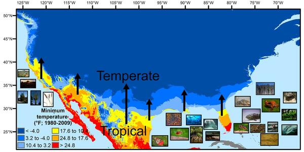
A map showing North America's tropical-to-temperate transition zone. Red, orange, and yellow depict the more tropical zones, and blues depict the more temperate zones, based on to the coldest recorded temperature for each area between 1980 and 2009.
A map showing North America's tropical-to-temperate transition zone. Red, orange, and yellow depict the more tropical zones, and blues depict the more temperate zones, based on to the coldest recorded temperature for each area between 1980 and 2009.

USGS hydrologist Adam Birken conducts equipment maintenance at the USGS streamgage on the South Fork of the Ogden River near Hunstville, Utah. This streamgage has been monitoring water levels and flow since March 21, 1921, making it one of 25 centennial gauges in Utah.
USGS hydrologist Adam Birken conducts equipment maintenance at the USGS streamgage on the South Fork of the Ogden River near Hunstville, Utah. This streamgage has been monitoring water levels and flow since March 21, 1921, making it one of 25 centennial gauges in Utah.

A U.S. Geological Survey streamgage near Hunstville, Utah is celebrating 100 years of monitoring streamflow on the south fork of the Ogden River. The streamgage has been monitoring water levels and flow since March 21, 1921, making it one of 25 centennial gauges in Utah.
A U.S. Geological Survey streamgage near Hunstville, Utah is celebrating 100 years of monitoring streamflow on the south fork of the Ogden River. The streamgage has been monitoring water levels and flow since March 21, 1921, making it one of 25 centennial gauges in Utah.

A U.S. Geological Survey streamgage near Hunstville, Utah is celebrating 100 years of monitoring streamflow on the south fork of the Ogden River. The streamgage has been monitoring water levels and flow since March 21, 1921, making it one of 25 centennial gauges in Utah.
A U.S. Geological Survey streamgage near Hunstville, Utah is celebrating 100 years of monitoring streamflow on the south fork of the Ogden River. The streamgage has been monitoring water levels and flow since March 21, 1921, making it one of 25 centennial gauges in Utah.

Photo Contest Winner | March 2021 | Where We Work
Aerial photo of Cold River in Maine
Photo Contest Winner | March 2021 | Where We Work
Aerial photo of Cold River in Maine

Lees Ferry streamgage and cableway downstream on the Colorado River, Arizona
Lees Ferry streamgage and cableway downstream on the Colorado River, Arizona

Metals and minerals are vital components of medical devices that allow millions of people to enjoy healthy lifestyles. Devices implanted into the human body can replace, support, or enhance an existing body part. Other devices can diagnose, monitor, or treat clinical conditions, both saving lives and improving people’s quality of life.
Metals and minerals are vital components of medical devices that allow millions of people to enjoy healthy lifestyles. Devices implanted into the human body can replace, support, or enhance an existing body part. Other devices can diagnose, monitor, or treat clinical conditions, both saving lives and improving people’s quality of life.

The Research Vessel Peterson Underway in San Francisco Bay.
The Research Vessel Peterson Underway in San Francisco Bay.
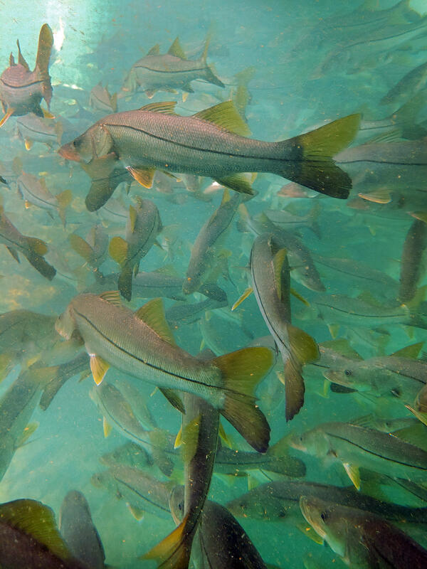
Winter temperature extremes control the distributions of subtropical fishes. Common snook (Centropomus undecimalis), aggregate at a spring in northern Florida during winter. Snook are warm saltwater game fish, common in Florida, that have been moving further northward as extreme cold spells become less frequent and less intense.
Winter temperature extremes control the distributions of subtropical fishes. Common snook (Centropomus undecimalis), aggregate at a spring in northern Florida during winter. Snook are warm saltwater game fish, common in Florida, that have been moving further northward as extreme cold spells become less frequent and less intense.

View of the lava lake from the south rim of Halema‘uma‘u, at the summit of Kīlauea, looking north. The western (left) portion of the lava lake remains active, with small scale crustal foundering events. Lava enters the lake at two sources approximately 20 to 30 meters (65 to 100 ft) apart at the base of the western vent spatter cone.
View of the lava lake from the south rim of Halema‘uma‘u, at the summit of Kīlauea, looking north. The western (left) portion of the lava lake remains active, with small scale crustal foundering events. Lava enters the lake at two sources approximately 20 to 30 meters (65 to 100 ft) apart at the base of the western vent spatter cone.

Agassiz Glacier: 8/5/1913 WC Alden, USGS Photographic Library - 8/24/2007, D Fagre, USGS
View the full collection at USGS Photographic Library
Agassiz Glacier: 8/5/1913 WC Alden, USGS Photographic Library - 8/24/2007, D Fagre, USGS
View the full collection at USGS Photographic Library

This map of Halema‘uma‘u at the summit of Kīlauea shows 20 m (66 ft) contour lines (dark gray) that mark locations of equal elevation above sea level (asl). The map shows that the lava lake has filled 221 m (725 ft) of the crater, to an elevation of 737 m (2418 ft) asl since the eruption began on December 20, 2020.
This map of Halema‘uma‘u at the summit of Kīlauea shows 20 m (66 ft) contour lines (dark gray) that mark locations of equal elevation above sea level (asl). The map shows that the lava lake has filled 221 m (725 ft) of the crater, to an elevation of 737 m (2418 ft) asl since the eruption began on December 20, 2020.