U.S. flag

An official website of the United States government

Images

Explore our planet through photography and imagery, including climate change and water all the way back to the 1800s when the USGS was surveying the country by horse and buggy.

Filter Total Items: 21351
Hue Shale and Kemik Sandstone
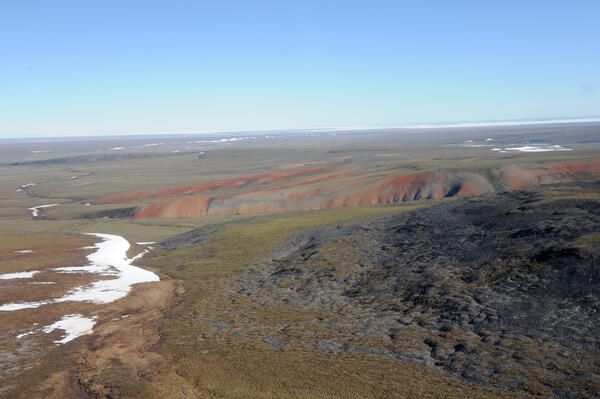
View to northeast from southwestern ANWR-1002 Area; ice in Camden Bay

View to northeast from southwestern Arctic National Wildlife Refuge-1002 Area with ice in Camden Bay in distance. In foreground, red-weathering rocks are Hue Shale (oil-prone source rock with is present throughout 1002 Area) and dark gray rocks are Kemik Sandstone (lateral equivalent to Thomson sandstone, main reservoir in Pt. Thomson field).

View to northeast from southwestern Arctic National Wildlife Refuge-1002 Area with ice in Camden Bay in distance. In foreground, red-weathering rocks are Hue Shale (oil-prone source rock with is present throughout 1002 Area) and dark gray rocks are Kemik Sandstone (lateral equivalent to Thomson sandstone, main reservoir in Pt. Thomson field).

near the Canning River Delta
View to the southeast from near the Canning River Delta

View to the southeast from near the Canning River Delta. Visible in foreground are permafrost polygons cut by caribou trails. 


Arctic National Wildlife Refuge

View to the southeast from near the Canning River Delta. Visible in foreground are permafrost polygons cut by caribou trails. 


Arctic National Wildlife Refuge

Well head of Sourdough oil discovery
Well head of Sourdough oil discovery on Alaska state lease

Well head of Sourdough oil discovery on Alaska state lease less than one mile west of Arctic National Wildlife Refuge-1002 Area showing minimal disturbance of permafrost polygons.   

Well head of Sourdough oil discovery on Alaska state lease less than one mile west of Arctic National Wildlife Refuge-1002 Area showing minimal disturbance of permafrost polygons.   

Well on Restored Prairie

A well at a restored prairie on Lake Agassiz beach ridge, Glacial Ridge National Wildlife Refuge

ANWR-1002 Area with ice in Camden Bay
western ANWR-1002 Area with ice in Camden Bay

Northward view in western Arctic National Wildlife Refuge-1002 Area with ice in Camden Bay in distance. North sloping, tundra-covered surface is typical of coastal plain.

Northward view in western Arctic National Wildlife Refuge-1002 Area with ice in Camden Bay in distance. North sloping, tundra-covered surface is typical of coastal plain.

western Sadlerochit Mountains
western Sadlerochit Mountains near the Tamayariak River

View to northeast from western Sadlerochit Mountains near the Tamayariak River. This gently rolling topography is typical of the southern coastal plain.

View to northeast from western Sadlerochit Mountains near the Tamayariak River. This gently rolling topography is typical of the southern coastal plain.

Will Dougherty carrying snapping turtle

Northeast Region Photo Contest Winner | June 2019 | People
Will Dougherty carrying snapping turtle

Yosemite toad
Yosemite toad caught on camera crossing beneath "toad road" structure

This is remote capture image of a Yosemite toad seen crossing beneath "toad road" structure built atop a forest road in the Sierra National Forest. Reseachers are exploring tools, such as this elevated road structure, or "toad road," to reduce vehicle strikes to this threatened species.

This is remote capture image of a Yosemite toad seen crossing beneath "toad road" structure built atop a forest road in the Sierra National Forest. Reseachers are exploring tools, such as this elevated road structure, or "toad road," to reduce vehicle strikes to this threatened species.

Scientists taking water quality samples near St. Mary’s, Alaska.
 Taking water quality samples in Alaska
 Taking water quality samples in Alaska
 Taking water quality samples in Alaska

Earl Alstrom and Carol Hasburgh taking water quality samples near St. Mary’s, Alaska.

​​​​​​​Cattaraugus Creek near Springville, NY

Photo Contest Winner | Nov. 2019 | Where We Work
Cattaraugus Creek near Springville, NY

​​​​​​​Crawfish groundwater measurement

Northeast Region Photo Contest Winner | Sept 2019 | USGS at Work
Crawfish groundwater measurement

image related to volcanoes. See description
A closer view of the braided section of the Fissure 8 channel, with Highway 132

A closer view of the braided section of the Fissure 8 channel, with Highway 132 cutting across both branches. USGS photo by M. Zoeller.

Two men walk along a path near one building towards another building with trees and a grassy lawn.
Building 1 and Credit Union on USGS Menlo Park campus

Building 1 formerly housed many different USGS groups, including the Western Coastal and Marine Geology team, but slowly has been leased out to other federal agencies like the Transportation Security Administration (TSA) and Veterans Affairs (VA). At the right is the Menlo Survey Federal Credit Union.

Building 1 formerly housed many different USGS groups, including the Western Coastal and Marine Geology team, but slowly has been leased out to other federal agencies like the Transportation Security Administration (TSA) and Veterans Affairs (VA). At the right is the Menlo Survey Federal Credit Union.

image related to volcanoes. See description
This photo looks north along the broad Fissure 8 channel. At its widest section

This photo looks north along the broad Fissure 8 channel. At its widest section, the Fissure 8 channel is about 430 meters (1400 feet wide). In the upper right section of the photo, Highway 132 can be seen cutting through the braided section of the channel. USGS photo by M. Zoeller.

This photo looks north along the broad Fissure 8 channel. At its widest section, the Fissure 8 channel is about 430 meters (1400 feet wide). In the upper right section of the photo, Highway 132 can be seen cutting through the braided section of the channel. USGS photo by M. Zoeller.

Photograph of a building in the distance with a flagpole in front of it, trees, cars parked, and grassy lawn in the foreground.
USGS Menlo Park campus

Building 3 on the USGS Western Region campus in Menlo Park, California.

Building 3 on the USGS Western Region campus in Menlo Park, California.

image related to volcanoes. See description
"Earthquake camp" of the Hayden expedition in 1871, located on the north shore o

"Earthquake camp" of the Hayden expedition in 1871, located on the north shore of Yellowstone Lake near Steamboat Point. Photo by William H. Jackson, courtesy Yellowstone National Park (https://www.nps.gov/features/yell/slidefile/history/jacksonphotos/Image…).

Dan Dzurisin conducting a leveling survey at Newberry Volcano
Dan Dzurisin
Dan Dzurisin
Dan Dzurisin

Dan Dzurisin, of the Cascades Volcano Observatory, conducting a leveling survey at Newberry Volcano, Oregon, in 2002.

Dan Dzurisin, of the Cascades Volcano Observatory, conducting a leveling survey at Newberry Volcano, Oregon, in 2002.

Was this page helpful?