
Fume from Pu`u `Ō `ō crater was relatively light today, allowing for nice views into the crater. The Halema`uma`u plume is in the background just below the clouds.
Images
Total: 0
Settings
Total: 0
Explore our planet through photography and imagery, including climate change and water all the way back to the 1800s when the USGS was surveying the country by horse and buggy.
Filter Total Items: 21606

Pu’u ‘Ō’ō Fume
Fume from Pu`u `Ō `ō crater was relatively light today, allowing for nice views into the crater. The Halema`uma`u plume is in the background just below the clouds.

TEB flow field
View of the current TEB flow field. The ocean entry continues, producing a weak plume scattered along the coastline. The lighter gray colored lava is the recent flow that has entered the vegetation and reached the pavement at the end of Highway 130. Plumes from the TEB shield and Pu`u `Ō `ō crater are on the horizon.
View of the current TEB flow field. The ocean entry continues, producing a weak plume scattered along the coastline. The lighter gray colored lava is the recent flow that has entered the vegetation and reached the pavement at the end of Highway 130. Plumes from the TEB shield and Pu`u `Ō `ō crater are on the horizon.
Tracking Radio-Tagged Yellow-Rumped Warbler
Dave Slager (Ohio State Univ.) tracks a radio-tagged yellow-rumped warbler to determine habitat use and length of stay during migration stopover at Trempealeau National Wildlife Refuge. This was a collaborative project involving USGS, USFWS and Ohio State Univ.
Dave Slager (Ohio State Univ.) tracks a radio-tagged yellow-rumped warbler to determine habitat use and length of stay during migration stopover at Trempealeau National Wildlife Refuge. This was a collaborative project involving USGS, USFWS and Ohio State Univ.
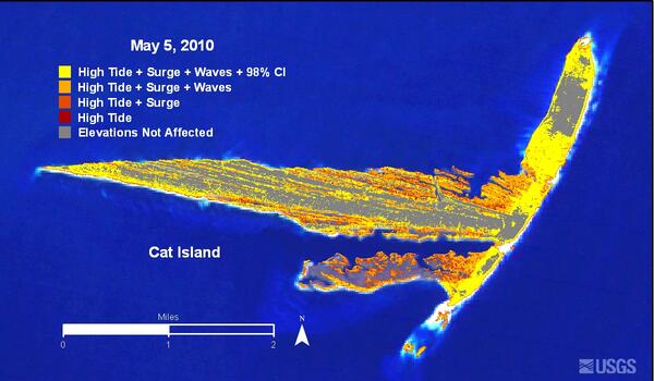
Cat Island Inundation Map
Areas likely to be inundated or overwashed during expected tide, surge, and wave conditions for May 5, 2010.
Areas likely to be inundated or overwashed during expected tide, surge, and wave conditions for May 5, 2010.

Lava breakouts on access road
Breakouts continued to be active on the east margin of the flow field, and hit the pavement of the Kalapana access road today creating thick black smoke from the burning asphalt.
Breakouts continued to be active on the east margin of the flow field, and hit the pavement of the Kalapana access road today creating thick black smoke from the burning asphalt.

Lava flow
Upslope from the west end near the Kalapana access road, scattered breakouts continued to be active.
Upslope from the west end near the Kalapana access road, scattered breakouts continued to be active.

Lava flow on road
Flows reached the pavement where the former viewing gate near the Kalapana access road resided.
Flows reached the pavement where the former viewing gate near the Kalapana access road resided.

Lava flow over viewing area
Flow expansion over the past day also covered most of the former lava viewing area near the Kalapana access road. The County has since relocated the viewing area farther east.
Flow expansion over the past day also covered most of the former lava viewing area near the Kalapana access road. The County has since relocated the viewing area farther east.

Pahoehoe pushing through vegetation
Just south of the Kalapana access road, active pahoehoe was pushing through thick vegetation, creating scattered brush fires and small methane bursts.
Just south of the Kalapana access road, active pahoehoe was pushing through thick vegetation, creating scattered brush fires and small methane bursts.

Pembina River
Pembina River in May at Neche, North Dakota.
Pembina River in May at Neche, North Dakota.

Petit Bois Island Inundation Map
Areas likely to be inundated or overwashed during expected tide, surge, and wave conditions for May 5, 2010.
Areas likely to be inundated or overwashed during expected tide, surge, and wave conditions for May 5, 2010.

Secretary Salazar Takes First Hand Look at Oil Spill Response
During his visit to Port Fourchon this morning, Secretary of the Interior Ken Salazar is briefed by Ron Ferguson, BP's Gulf of Mexico Shore Base coordinator, on the 40-foot metal containment structure that is being transported to the site of the leak and deployed to the seabed during the next 48 hours to cover the largest leak at the end of the broken riser pipe.
During his visit to Port Fourchon this morning, Secretary of the Interior Ken Salazar is briefed by Ron Ferguson, BP's Gulf of Mexico Shore Base coordinator, on the 40-foot metal containment structure that is being transported to the site of the leak and deployed to the seabed during the next 48 hours to cover the largest leak at the end of the broken riser pipe.

Buck Creek Watershed
Stream Flow and Chemistry Monitoring Stations in Buck Creek Watershed, NY
Stream Flow and Chemistry Monitoring Stations in Buck Creek Watershed, NY

Bumblebee Gecko from Papua New Guinea
The Bumblebee Gecko (Nactus kunan), from Papua New Guinea was discovered in 2010, and described as a new species in 2012. The yellow and black gecko is about 5 inches long.
The Bumblebee Gecko (Nactus kunan), from Papua New Guinea was discovered in 2010, and described as a new species in 2012. The yellow and black gecko is about 5 inches long.

Bumblebee Gecko from Papua New Guinea
The Bumblebee Gecko (Nactus kunan), from Papua New Guinea was discovered in 2010, and described as a new species in 2012.
The Bumblebee Gecko (Nactus kunan), from Papua New Guinea was discovered in 2010, and described as a new species in 2012.

Bumblebee Gecko from Papua New Guinea
The Bumblebee Gecko (Nactus kunan), from Papua New Guinea was discovered in 2010, and described as a new species in 2012. The yellow and black gecko is about 5 inches long.
The Bumblebee Gecko (Nactus kunan), from Papua New Guinea was discovered in 2010, and described as a new species in 2012. The yellow and black gecko is about 5 inches long.

Lava Stream
One of several lava streams on the shore of Kilauea volcano.
One of several lava streams on the shore of Kilauea volcano.

Ocean Entry
The ocean entry that started on April 29 continues, and has expanded in width.
The ocean entry that started on April 29 continues, and has expanded in width.

Oil Spill in the Gulf of Mexico - Landsat 7
On April 20, 2010, an explosion at an oil well in the Gulf of Mexico resulted in a major oil spill. Since then, emergency response efforts have been underway to contain the growing oil slick before it reaches the southern coast of the United States. Landsat imagery, acquired by the U.S. Geological Survey on May 1 shows the extent of the oil slick.
On April 20, 2010, an explosion at an oil well in the Gulf of Mexico resulted in a major oil spill. Since then, emergency response efforts have been underway to contain the growing oil slick before it reaches the southern coast of the United States. Landsat imagery, acquired by the U.S. Geological Survey on May 1 shows the extent of the oil slick.

Cannonball River
The Cannonball River in the spring at Breien, ND.
The Cannonball River in the spring at Breien, ND.