



Regional Super El Niño Impacts: Hawaiʻi and the U.S.-Affiliated Pacific Islands
Explore the forecasted impacts of the 2026 El Niño in Hawaiʻi and the U.S.-Affiliated Pacific Islands and its implications for the management of natural resources.
What Does El Niño Mean for Hawaiʻi and the U.S.-Affiliated Pacific Islands?
The U.S.-Affiliated Pacific Islands (USAPI) includes the Commonwealth of the Northern Mariana Islands (CNMI), the unincorporated territories of American Sāmoa, Guam, and the Pacific Remote Islands (PRI); and the Freely Associated States (FAS): the Federated States of Micronesia (FSM), the Republic of the Marshall Islands (RMI), and the Republic of Palau, alongside the state of Hawaiʻi, spread across millions of square miles in the Pacific Ocean. El Niño impacts vary considerably by island group. The Pacific Islands region has fewer downscaled climate products and tools available than the continental U.S., making it difficult to sharpen the odds more pointedly.

Strong Links
Hawaiʻi and the USAPI sit near the center of large-scale ocean-atmosphere interactions that drive El Niño. This region experiences some of the most pronounced impacts of any part of the U.S. during these events. A very strong El Niño shifts the odds of particular outcomes rather than guaranteeing them. El Niño can generate significant climate hazards and severe weather events across the region, including an increased risk of intense tropical cyclones, extreme precipitation or drought, invasive species spread, and coral bleaching.
Storms
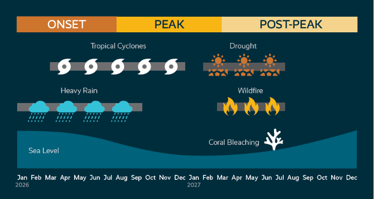
During El Niño, weakened trade winds and a warmer central and eastern Pacific basin shift toward favorable storm-forming conditions eastward, such that storms are more likely to form and track over the USAPI, rather than primarily impacting Asia. Guam, CNMI, FSM, and Hawaiʻi typically see increased tropical cyclone risk, while Palau typically sees reduced risk as storm formation shifts north and east of it. Conditions around American Sāmoa are less consistent. This pattern is already unfolding in 2026: the Central Pacific hurricane season is running well above normal, with Hurricane Lala nearly making a historical direct hit on the Big Island and ranking as Hawaiʻi's third-wettest tropical cyclone on record. Earlier in the year, Super Typhoons Sinlaku and Bavi struck CNMI and Guam only 83 days apart, leaving residents without water for weeks and without power for nearly two months. Initial damages were estimated at \$1.5 billion, and impacts of biosecurity costs are still unfolding. Even so, the El Niño–typhoon relationship is not deterministic: the 2023 El Niño produced an unusually inactive Western Pacific typhoon season because other ocean-temperature patterns temporarily overrode the usual signal. Storm tracks also tend to become less predictable during El Niño years, so seasonal outlooks describe overall activity levels rather than where any individual storm will make landfall.
Drought
Extended drought typically follows the peak of the El Niño cycle, roughly September through March, though timing and severity vary by island and by whether the event is an Eastern-Pacific (the most significant ocean warming is near South America) or Central-Pacific (the most significant warming is near the International Dateline) type El Niño. For Guam, Saipan, and Chuuk, the sharpest historical drought signal has typically arrived in the year after El Niño onset rather than during onset itself, suggesting the most acute drought risk for these islands may fall in early-to-mid 2027. Atoll islands face a more acute water-security risk than high volcanic islands: freshwater exists as a thin lens floating on seawater, often only a few meters thick, and small islands can lose their freshwater lens entirely during a severe drought. The Marshall Islands experienced a serious El Niño-linked drought as recently as 2023–2024, and Hawaiʻi enters this event already in significant drought, with 2025 ranking as the second-driest year on record statewide.
Coral Bleaching
Elevated sea surface temperatures combined with lower-than-normal sea levels raise bleaching risks during and after El Niño's peak. Mass bleaching can occur with as little as 1°C of sustained warming over four to six weeks, and lower sea levels can expose shallow reefs directly to air. In one of the most severe documented bleaching events in the Pacific, the 2014–16 El Niño bleached more than 90% of monitored reefs at Palmyra Atoll. Some islands (Palau, FSM, Guam, CNMI) tend to see cooler-than-normal water during El Niño, which can moderate local bleaching risk even as it shifts tuna away from their usual range, with potential cultural, ecological, and economic impacts. Hawaiʻi tends to see the opposite, with warmer water and increased tuna catch.
Sea Level
El Niño events reliably lower sea level across the northwestern tropical Pacific, with Guam and the Marshall Islands seeing a statistically significant drop from roughly July through the following March. The drop in American Sāmoa's, when it occurs, lags about six months behind, tracking the southward migration of the same wind pattern. Because of this, El Niño years are not typically when these islands see their worst nuisance or tidal flooding. Independent of ENSO phase, minor flood frequency has risen sharply across the region over the long term, from about 2 days a year to 20–22 in Guam and Majuro, and from essentially zero to over 100 days a year in Pago Pago, American Sāmoa.
Invasive Species
Emergency response efforts and reconstruction logistics after a major storm create a pathway for invasive species to reach islands they have not yet colonized. Within weeks of Super Typhoon Bavi striking Rota in July 2026, CNMI wildlife officials confirmed two invasive brown tree snake encounters tied to relief cargo transshipped through Guam, where the snake is established and has caused the extinction of most native forest birds and routinely impacts infrastructure, leading to repeated power outages. There are currently no established brown tree snake populations in CNMI. The same storm-recovery pathway has previously spread little fire ants and contributed to spread of the coconut rhinoceros beetle, which thrives in “green waste” storm debris.
Fisheries
El Niño affects tuna availability through both a well-known eastward shift in warm water and a less widely recognized oxygen effect: in the western Pacific, including the exclusive economic zones (EEZs) of Palau, FSM, and RMI, El Niño compresses the oxygenated water tuna can occupy, pushing them closer to the surface where they become easier to catch and more vulnerable to overfishing. Access fees paid by foreign fishing fleets are a significant source of government revenue for these nations, so this carries direct economic stakes beyond the fishery itself.
Seasonal Forecasts for the Pacific Islands
A comparison of downscaled seasonal precipitation and temperature models is not available for the Pacific Islands because the high-resolution downscaled model products used elsewhere do not exist for this region. Only coarser global-scale model output is available. This reflects a long-documented gap in climate monitoring infrastructure for the Pacific and it means confidence statements for this region rely more heavily on historical analogs and current-season tropical cyclone outlooks than on downscaled model agreement.
Official current-season tropical cyclone guidance is available. NOAA's Central Pacific Hurricane Center outlook called for a 70% chance of an above-normal season for Hawaiʻi, and the basin's accumulated cyclone energy is currently running about 90% above the long-term normal. NOAA's Western North Pacific outlook, issued in June, forecasts above-normal typhoon activity for FSM, RMI, CNMI, and Guam, and normal-to-below-normal activity for Palau, consistent with the eastward shift in storm formation typically seen during El Niño. Both outlooks describe overall seasonal activity rather than where or when any individual storm may make landfall.
What Does This Mean for the Management of Natural Resources?
Current, real-time drought and precipitation conditions for 2026 were not available at time of writing for Guam, CNMI, FSM, Palau, or American Sāmoa. Resource managers in these jurisdictions may want to reach out directly to regional monitoring partners for the most current available information rather than rely on historical averages alone.
Pre-Storm Management Options:
- Monitor basin-specific NOAA/NWS seasonal and short-term tropical cyclone outlooks as guidance on activity levels rather than landfall forecasts.
- Pre-position emergency water, fuel, medical supplies, and water purification equipment, particularly for CNMI and Guam communities still recovering from this year's storms.
- Protect and restore natural coastal infrastructure such as coral reefs, mangroves, and seagrasses to buffer storm surge and erosion.
- Establish or refresh post-typhoon invasive species inspection protocols before storms hit.
- Plan for the possibility of rapid or complete freshwater lens depletion on atoll islands during severe drought.
- Plan water conservation and agricultural contingencies with an eye toward 2027, since the sharpest USAPI drought risk tends to follow El Niño onset by several months to a year.
Post-Storm Management Options:
- Encourage invasive early detection and rapid response (EDRR) training, increase vigilance, and encourage rapid public reporting of invasive species along transportation and relief-cargo pathways; early detection before establishment is far more effective and less costly than eradication after invasion.
- Reinstall or reinforce species-control infrastructure, such as traps and bait stations, as quickly as possible after a storm disrupts them.
- Coordinate biosecurity inspection across origin and destination islands; employ redundant inspection, once before cargo departs and again on arrival, as this method has proven more effective than inspection at a single point.
- Use drone technologies, remote sensing, and high-resolution imagery to assess coral bleaching severity and extent quickly, helping direct limited management resources where they are needed most.
- Continue monitoring reef health and prioritize areas most likely to survive or recover from bleaching for conservation focus.
- For Palau, FSM, and RMI fisheries managers, El Niño-driven habitat compression can increase tuna catchability and overfishing risk even without any change in overall stock size, a dynamic that standard catch-per-unit-effort assessments may not fully capture.
Regional monitoring resources include the Central Pacific Hurricane Center and NWS Weather Forecast Office Guam for tropical cyclone outlooks, and the Hawaiʻi Climate Data Portal for Hawaiʻi-specific drought, rainfall, and wildfire potential products.
Island-by-Island Outlook
Hawaiian Islands
Hawaiʻi enters this El Niño already in a significant, multi-year drought. 2025 was the second-driest year on record statewide and the driest ever for Maui. Drought duration and severity across the islands have trended upward for decades. El Niño's typical signature for Hawaiʻi is a drier wet season (November–April) and a wetter dry season (May–October), alongside weaker trade winds, warmer nearshore waters, and elevated wildfire risk once wet-season vegetation growth cures during the subsequent dry stretch. The two worst droughts in Hawaiʻi's 100-year record, 2007–2014 and 1998–2002, both followed El Niño onset, though imperfectly. Not every El Niño produces a Hawaiʻi drought (1987–88 did not), and not every Hawaiʻi drought follows an El Niño (2012–2013 did not).
This year's Central Pacific hurricane season has already validated the seasonal outlook: NOAA forecast a 70% chance of an above-normal season, and the basin's accumulated cyclone energy is currently running 90% above normal. Hurricane Lala, which reached major hurricane strength (115 knots) after crossing the islands in mid-August, was Hawaiʻi's third-wettest tropical cyclone on record, with over 43 inches of rain recorded at Laupāhoehoe and significant impacts on infrastructure and ecosystems across the island chain. This is consistent with decades of statistical evidence that Hawaiʻi sees both more frequent tropical cyclones and more erratic storm tracks during El Niño years. El Niño also measurably increases high-surf activity and associated coastal hazard on north- and west-facing shores, with an average of 65 high-surf days per El Niño winter versus 56 in La Niña winters.
Guam and CNMI
NOAA is forecasting an above-normal typhoon season for Guam and CNMI. This is already playing out. Super Typhoons Sinlaku and Bavi struck the two jurisdictions only 83 days apart. Saipan and Rota were hit especially hard, experiencing extended water and power outages and sustaining roughly \$1.5 billion in damage. In the wake of Bavi, CNMI has already confirmed two separate brown tree snake incidents on Rota tied to relief cargo transshipped through Guam, demonstrating the invasive-species risk that follows major storm recovery efforts. Sea level in Guam drops measurably during El Niño (July–March), which somewhat reduces minor tidal flooding risk during the event itself, even as the islands' longer-term minor-flood frequency has risen sharply regardless of ENSO phase.
Federated States of Micronesia
Above-normal typhoon activity for FMS is forecast in 2026. The sharpest drought risk for FSM's westernmost islands (Yap and areas near Chuuk) tends to arrive in the year after El Niño onset. FSM's atoll communities face the same acute freshwater-lens vulnerability documented for RMI; a parallel modeling study found only 6 of 105 inhabited FSM islands would have adequate groundwater to sustain their population through a drought as severe as 1998's. FSM's EEZ is also among the most affected in the Pacific by El Niño-driven tuna habitat compression, with direct implications for licensing revenue.
Republic of the Marshall Islands
Above-normal typhoon activity for RMI is forecast in 2026. Historical analysis found typhoons roughly 2.6 times more likely in El Niño years than in non-El Niño years for the Marshall Islands, specifically. RMI's atolls have an average freshwater lens thickness of only 3.6 meters (more than half of islands have lenses under 2.5 meters thick), making it acutely vulnerable to El Niño droughts. As recently as 2023–2024, an El Niño-linked drought pushed Majuro's reservoir to 71% capacity and left Kwajalein and Wotje Atolls in severe drought, prompting an international disaster response. RMI has limited time to recover between events: comparably severe droughts occurred in 2015–2016, 2019 (a declared state of emergency), and 2023–2024.
Republic of Palau
In Palau, El Niño is often associated with lower-than-average sea levels, drier conditions and drought, and cooler sea surface temperatures due to the upwelling of colder deep water. Palau experienced these conditions during the strong 1997–1998 and 2015–2016 El Niño events. Palau is the exception to the regional typhoon pattern. NOAA's 2026 outlook, consistent with the long-term climatology, calls for normal-to-below-normal typhoon activity this year, as the eastward shift in storm formation during El Niño keeps most storms north of Palau. Palau does, however, face elevated drought risk during El Niño, historically among the more severe in the region. It is among the Pacific Island EEZs most affected by El Niño-driven tuna habitat compression.
American Sāmoa
El Niño’s impacts on American Sāmoa are the most uncertain of the Paficic Islands. American Sāmoa sits near the pivot point of El Niño-driven shifts in the South Pacific Convergence Zone, which helps explain why its rainfall and cyclone response is less consistent across events than the northern islands. Some analyses find comparatively little sensitivity to El Niño, while others describe increased cyclone risk in the November–January window. Lowered sea-levels, when present, lag Guam and the Marshall Islands by roughly six months. American Sāmoa's long-term minor-flood frequency has risen more dramatically than anywhere else in the region, from essentially zero days a year to over 100, largely driven by island subsidence. Current conditions specific to American Sāmoa were not available as of August 2026.
Questions?
Contact the Pacific Islands CASC if you’d like to discuss this El Niño and adaptation strategies for management of your resources.