
Projecting Accelerated Erosion of O‘ahu's Shorelines
Hawai‘i’s iconic beaches—essential to the state’s identity, economy, and ecosystems—are disappearing faster than previously predicted. New projections of shoreline change by the University of Hawai‘i at Mānoa and USGS finds that 81% of sandy shorelines on the island of O‘ahu could be lost by the end of the century, with nearly 40% of that loss occurring within just the next five years.
Using the CoSMoS-COAST shoreline change model—supplemented with satellite-derived shoreline data, historical wave patterns, and on-the-ground beach surveys—researchers found that beach erosion is advancing at a significantly faster pace than earlier estimates. For a projected sea level rise of just 0.3 meters by 2050, the model forecasts a 43% increase in landward shoreline retreat compared to previous predictions.
“Shoreline models developed by University of Hawai’i over the past few decades helped to inspire development of our USGS CoSMoS-COAST model,” said USGS Research Oceanographer Dr. Sean Vitousek, a co-author of the study. “And with this recent collaboration, I’ve been fortunate to share some of our new approaches with them.”
This study found that heightened rates of erosion stem not just from rising seas, but also from dynamic coastal processes such as cross-shore and alongshore sediment transport. These wave-driven forces account for more than a third of the projected shoreline change through the year 2100, especially affecting O‘ahu’s north and west shores.
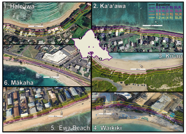
Previous models lacked sufficient shoreline data to account for the seasonal and longer-term behavior of waves and sediment transport in shaping O‘ahu’s coastlines. By integrating new satellite-derived shoreline data with wave-driven transport models, the study provides a clearer, starker picture of coastal change to come.
These findings have implications for O‘ahu’s coastal planning and development, suggesting updates to shoreline policies that rely upon erosion forecasting, and highlights the importance of incorporating satellite data as well as cross-shore and alongshore transport in erosion models for other Pacific islands.
Related

CoSMoS-COAST
Related