



2027 Long-term National Seismic Hazard Models for the U.S. Territories of Guam, Commonwealth of the Northern Mariana Islands, and American Samoa
The U.S. Geological Survey will publish an updated National Seismic Hazard Model for the Pacific territories of Guam, Commonwealth of the Northern Mariana Islands, and American Samoa in 2027. These models were last updated in 2012.
Table of Contents
Summary
Activities
Documentation
Project Timeline
Summary
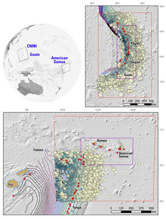
The inhabited U.S. Pacific island territories of Guam, the Commonwealth of the Northern Mariana Islands, and American Samoa lie near the Pacific plate boundary, experience appreciable seismic hazard, and are home to ~265,000 people. Models of probabilistic seismic hazard by the U.S. Geological Survey (USGS) for these islands were last published in 2012. The National Seismic Hazard Modeling group at the USGS is updating this model with current earthquake catalogs, recent fault mapping, and new ground-motion models and analysis of observed ground motions. Further, new and revised methods for using and combining this information are being applied, and include, for example, methods related to catalog declustering and fault-system inversion.
Activities
The National Seismic Hazard Model Project (NSHMP) hosted a public webinar on February 24, 2025 as a kick-off event for the update.
Upcoming webinars and meetings are announced here: NSHMP Workshops
Documentation
Tables of Overview Documentation, Data, and Software will be posted in this section.
Project Timeline
The updates for GNMI and AmSam will follow the timeline below, which allows for:
- 2 years of development, including evaluations of non-USGS source and ground motion models;
- Community feedback early and often, e.g., a public kick-off workshop in February 2025, and additional workshops scheduled throughout the update process (Workshop information will be posted as soon as available); and
- 1 year for publication, including reconciliation of reviews from a peer-reviewed journal, the NSHM Steering Committee, building code and other users, and the public.

The USGS requests that the seismic hazard community bring to our attention, by June 30 of 2024, new earthquake source and ground motion data and models that could be included in the GNMI and AmSam updates.
Only published (or accepted for publication), peer-reviewed data and models will be considered. The sooner they are brought to our attention, the more likely it is we can include them in the updated NSHMs, resources permitting. Given current staffing levels, it is likely that relatively few changes will be included in the 2027 updates. Please bring the publications to our attention by emailing nshmp-support@usgs.gov. Someone will reply to confirm receipt and request additional information, if needed.

Project Pages for Seismic Hazard Modeling

2027 NSHMs for GNMI and AmSam

National Seismic Hazard Model
The U.S. Geological Survey will publish an updated National Seismic Hazard Model for the Pacific territories of Guam, Commonwealth of the Northern Mariana Islands, and American Samoa in 2027. These models were last updated in 2012.
Table of Contents
Summary
Activities
Documentation
Project Timeline
Summary
The inhabited U.S. Pacific island territories of Guam, the Commonwealth of the Northern Mariana Islands, and American Samoa lie near the Pacific plate boundary, experience appreciable seismic hazard, and are home to ~265,000 people. Models of probabilistic seismic hazard by the U.S. Geological Survey (USGS) for these islands were last published in 2012. The National Seismic Hazard Modeling group at the USGS is updating this model with current earthquake catalogs, recent fault mapping, and new ground-motion models and analysis of observed ground motions. Further, new and revised methods for using and combining this information are being applied, and include, for example, methods related to catalog declustering and fault-system inversion.
Activities
The National Seismic Hazard Model Project (NSHMP) hosted a public webinar on February 24, 2025 as a kick-off event for the update.
Upcoming webinars and meetings are announced here: NSHMP Workshops
Documentation
Tables of Overview Documentation, Data, and Software will be posted in this section.
Project Timeline
The updates for GNMI and AmSam will follow the timeline below, which allows for:
- 2 years of development, including evaluations of non-USGS source and ground motion models;
- Community feedback early and often, e.g., a public kick-off workshop in February 2025, and additional workshops scheduled throughout the update process (Workshop information will be posted as soon as available); and
- 1 year for publication, including reconciliation of reviews from a peer-reviewed journal, the NSHM Steering Committee, building code and other users, and the public.
The USGS requests that the seismic hazard community bring to our attention, by June 30 of 2024, new earthquake source and ground motion data and models that could be included in the GNMI and AmSam updates.
Only published (or accepted for publication), peer-reviewed data and models will be considered. The sooner they are brought to our attention, the more likely it is we can include them in the updated NSHMs, resources permitting. Given current staffing levels, it is likely that relatively few changes will be included in the 2027 updates. Please bring the publications to our attention by emailing nshmp-support@usgs.gov. Someone will reply to confirm receipt and request additional information, if needed.
Project Pages for Seismic Hazard Modeling
2027 NSHMs for GNMI and AmSam