
2026 Venezuela Sequence Earthquake-triggered Landslide Hazards
On Wednesday, June 25th, 2026, a pair of Magnitude 7.2 and Magnitude 7.5 earthquakes occurred in northern Venezuela, west of Caracas. The U.S. Geological Survey (USGS) Ground Failure product estimated that landslides triggered by this earthquake would likely be significant in number and/or spatial extent.
This landslide event page serves to communicate timely science information to our partners. This page includes what is currently understood about the landslides triggered by the event sequence based on ongoing assessments of satellite imagery, and may be subject to change. For more information about the earthquake sequence, refer to the USGS Earthquake Event pages (see links below).
Our thoughts go out to the millions of people affected by the 2026 Venezuela earthquakes and the significant earthquake impacts from the shaking that continues to impact the region.
Field Photos | Observations | More Information | Publications | Data
How to stay safe:
- Landslides can still happen for the next few days to weeks. Aftershocks and heavy rainfall can trigger additional landslide activity. Pay attention to weather alerts. Follow emergency messages from local authorities.
- Pay attention to the landslide warning signs. Landslide warning signs include new cracks forming on the ground, leaning trees, new springs, or falling rocks.
- Use caution clearing landslides that are blocking roads. Consider consulting a professional geologist or engineer. Removing material may remobilize the landslide. Aftershocks may also trigger additional landslides. Downed power lines or other hazards may be hidden under landslide deposits.
- If a landslide has impacted your home, or you see signs of a landslide, contact your local emergency services. Local officials are best able to assess potential danger. If the danger is not immediate, seek guidance from a qualified professional engineering geologist or civil engineer.
Learn more about landslide preparedness.
Landslide Safety
Landslide Preparedness
What we are doing
The USGS is analyzing shaking and ground failure models (available on the USGS earthquake event pages for the M7.2 and M 7.5) and remote imagery to provide situational awareness for response operations and safety of responders. The USGS is sharing information on likely earthquake and landslide impacts and persistent threats to support the U.S. Government’s response. The USGS landslide focus has been on assessing transportation impacts, identifying isolated communities, and searching for landslide dams that may pose downstream flooding hazards.
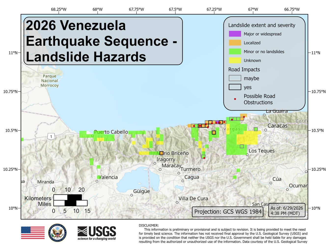
In the days after the earthquake, the USGS conducted a preliminary assessment of landslide hazards in areas with high likelihood of landslides. These priority areas were selected based on USGS model results. Assessments were conducted with high-resolution satellite imagery but are limited by cloud coverage or lack of available imagery over the priority areas.
Preliminary findings based on available high-resolution, cloud-free satellite imagery are summarized in Figure 1. Verification remains ongoing.
Overall observation summary:
- Based on the preliminary incomplete assessment, landslides do not appear to be as significant as initial models predicted.
- Localized landslides are impacting the coastal roads west of Catia La Mar.
- Rockfall and boulders appear to be the most significant obstructions on roads.
- Communities may be isolated due to partially or fully blocked roadways, and some inland populations may be cut off from coastal communities.
Contributors to this page include Marísa Macías, Lillian Hanson, Kate Allstadt, Stephen Slaughter, Corina Cerovski-Darriau, Eric Jones, and Robert Schmitt.
View the Earthquake Engineering Research Institute’s event page for a compilation of products.
Learn more about landslides.
Learn more about landslide preparedness.
Learn more about the Landslide Hazards Program.
Learn more about USGS Landslide Response.
| Disclaimer: This information is preliminary or provisional and is subject to revision. It is being provided to meet the need for timely best science. The information has not received final approval by the U.S. Geological Survey (USGS) and is provided on the condition that neither the USGS nor the U.S. Government shall be held liable for any damages resulting from the authorized or unauthorized use of the information. |
On Wednesday, June 25th, 2026, a pair of Magnitude 7.2 and Magnitude 7.5 earthquakes occurred in northern Venezuela, west of Caracas. The U.S. Geological Survey (USGS) Ground Failure product estimated that landslides triggered by this earthquake would likely be significant in number and/or spatial extent.
This landslide event page serves to communicate timely science information to our partners. This page includes what is currently understood about the landslides triggered by the event sequence based on ongoing assessments of satellite imagery, and may be subject to change. For more information about the earthquake sequence, refer to the USGS Earthquake Event pages (see links below).
Our thoughts go out to the millions of people affected by the 2026 Venezuela earthquakes and the significant earthquake impacts from the shaking that continues to impact the region.
Field Photos | Observations | More Information | Publications | Data
How to stay safe:
- Landslides can still happen for the next few days to weeks. Aftershocks and heavy rainfall can trigger additional landslide activity. Pay attention to weather alerts. Follow emergency messages from local authorities.
- Pay attention to the landslide warning signs. Landslide warning signs include new cracks forming on the ground, leaning trees, new springs, or falling rocks.
- Use caution clearing landslides that are blocking roads. Consider consulting a professional geologist or engineer. Removing material may remobilize the landslide. Aftershocks may also trigger additional landslides. Downed power lines or other hazards may be hidden under landslide deposits.
- If a landslide has impacted your home, or you see signs of a landslide, contact your local emergency services. Local officials are best able to assess potential danger. If the danger is not immediate, seek guidance from a qualified professional engineering geologist or civil engineer.
Learn more about landslide preparedness.
Landslide Safety
Landslide Preparedness
What we are doing
The USGS is analyzing shaking and ground failure models (available on the USGS earthquake event pages for the M7.2 and M 7.5) and remote imagery to provide situational awareness for response operations and safety of responders. The USGS is sharing information on likely earthquake and landslide impacts and persistent threats to support the U.S. Government’s response. The USGS landslide focus has been on assessing transportation impacts, identifying isolated communities, and searching for landslide dams that may pose downstream flooding hazards.
In the days after the earthquake, the USGS conducted a preliminary assessment of landslide hazards in areas with high likelihood of landslides. These priority areas were selected based on USGS model results. Assessments were conducted with high-resolution satellite imagery but are limited by cloud coverage or lack of available imagery over the priority areas.
Preliminary findings based on available high-resolution, cloud-free satellite imagery are summarized in Figure 1. Verification remains ongoing.
Overall observation summary:
- Based on the preliminary incomplete assessment, landslides do not appear to be as significant as initial models predicted.
- Localized landslides are impacting the coastal roads west of Catia La Mar.
- Rockfall and boulders appear to be the most significant obstructions on roads.
- Communities may be isolated due to partially or fully blocked roadways, and some inland populations may be cut off from coastal communities.
Contributors to this page include Marísa Macías, Lillian Hanson, Kate Allstadt, Stephen Slaughter, Corina Cerovski-Darriau, Eric Jones, and Robert Schmitt.
View the Earthquake Engineering Research Institute’s event page for a compilation of products.
Learn more about landslides.
Learn more about landslide preparedness.
Learn more about the Landslide Hazards Program.
Learn more about USGS Landslide Response.
| Disclaimer: This information is preliminary or provisional and is subject to revision. It is being provided to meet the need for timely best science. The information has not received final approval by the U.S. Geological Survey (USGS) and is provided on the condition that neither the USGS nor the U.S. Government shall be held liable for any damages resulting from the authorized or unauthorized use of the information. |