During September 2017, Hurricane Maria triggered >70,000 slope failures throughout the mountainous regions of Puerto Rico (USA). Since then, the USGS has had a multi-faceted team working to understand landslide hazards in Puerto Rico.
Corina Cerovski-Darriau
Corina leads the USGS-USAID Landslide Disaster Assistance Team (LDAT), which collaborates with international partners on landslide hazard projects. Her expertise is remote and field mapping of surface processes, monitoring hydrologic change and sediment transport, and modeling landslide hazards.
As the USGS-USAID Landslides Hazards Advisor and Landslide Disaster Assistance Team (LDAT) manager, Corina oversees a variety of international educational and technical capacity building projects as part of a joint USGS and USAID Bureau for Humanitarian Assistance program. These projects work closely with in-country counterparts to support landslide mapping and monitoring efforts. Corina’s focus is capacity building to assess landslide hazards and create landslide awareness in order to prepare for future landslide events, and acting as a liaison between USGS and USAID.
Her past research covered various topics in hillslope geomorphology – from producing geomorphic process maps to identify and quantify sediment erosion sources, to monitoring how long wildfire impacts soil hydraulic conductivity post-fire, to conducting landslide hazard assessment through field and remote mapping, to sampling and dating material properties to understand landscape evolution. Her scientific interest is the interaction of longer-term geomorphic processes on short-term hazards.
Professional Experience
2023-present Geologist, U.S. Geological Survey, Golden, CO
2017-2022 Research Geologist, U.S. Geological Survey, Menlo Park/Moffett Field, CA
2016-2017 Mendenhall Post-doctoral Researcher, U.S. Geological Survey, Menlo Park, CA
2010-2016 Research/Teaching Assistant, Univ. of Oregon, Dept. of Earth Sciences, Eugene, OR
2008-2010 Policy Associate, Govt. Affairs Program, AGI, Alexandria, VA
Education and Certifications
Ph.D., Geological Sciences, University of Oregon, 2016
B.A., Earth and Planetary Sciences, University of California, Berkeley, 2008
Science and Products
Characterizing high-resolution soil burn severity, erosion risk, and recovery using Uncrewed Aerial Systems (UAS)
Landslide Inventory for Chuuk, Federated States of Micronesia (FSM) 2003 - 2022
Results from additional dynamic cone penetration testing of soils on the Utuado Batholith, upland and dissected terrains, Puerto Rico - June 2022
Field observations of landslides and related materials following Hurricane Maria, Puerto Rico
Data from "Mapping bedrock outcrops in the Sierra Nevada Mountains (California, USA) using machine learning"
Field-saturated hydraulic conductivity time series and sediment accumulations following the 2017 Nuns and Tubbs wildfires, Napa and Sonoma Counties, CA, USA
Field observations of ground failure triggered by the 2020 Puerto Rico earthquake sequence
Map data from landslides triggered by Hurricane Maria in four study areas of Puerto Rico
Infiltration data collected post-Hurricane Maria across landslide source area materials, Puerto Rico, USA
During September 2017, Hurricane Maria triggered >70,000 slope failures throughout the mountainous regions of Puerto Rico (USA). Since then, the USGS has had a multi-faceted team working to understand landslide hazards in Puerto Rico.
Multi-stage soil-hydraulic recovery and limited ravel accumulations following the 2017 Nuns and Tubbs wildfires in Northern California
Sediment budget for watersheds of West Maui, Hawaii
Mobility characteristics of landslides triggered by Hurricane Maria in Puerto Rico
Where’s the rock: Using convolutional neural networks to improve land cover classification
Landslides triggered by Hurricane Maria: Assessment of an extreme event in Puerto Rico
Hurricane Maria hit the island of Puerto Rico on 20 September 2017 and triggered more than 40,000 landslides in at least three-fourths of Puerto Rico’s 78 municipalities. The number of landslides that occurred during this event was two orders of magnitude greater than those reported from previous hurricanes. Landslide source areas were commonly limited to surficial soils but also extended into und
Science and Products
Characterizing high-resolution soil burn severity, erosion risk, and recovery using Uncrewed Aerial Systems (UAS)
Landslide Inventory for Chuuk, Federated States of Micronesia (FSM) 2003 - 2022
Results from additional dynamic cone penetration testing of soils on the Utuado Batholith, upland and dissected terrains, Puerto Rico - June 2022
Field observations of landslides and related materials following Hurricane Maria, Puerto Rico
Data from "Mapping bedrock outcrops in the Sierra Nevada Mountains (California, USA) using machine learning"
Field-saturated hydraulic conductivity time series and sediment accumulations following the 2017 Nuns and Tubbs wildfires, Napa and Sonoma Counties, CA, USA
Field observations of ground failure triggered by the 2020 Puerto Rico earthquake sequence
Map data from landslides triggered by Hurricane Maria in four study areas of Puerto Rico
Infiltration data collected post-Hurricane Maria across landslide source area materials, Puerto Rico, USA
During September 2017, Hurricane Maria triggered >70,000 slope failures throughout the mountainous regions of Puerto Rico (USA). Since then, the USGS has had a multi-faceted team working to understand landslide hazards in Puerto Rico.
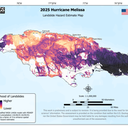
Multi-stage soil-hydraulic recovery and limited ravel accumulations following the 2017 Nuns and Tubbs wildfires in Northern California
Sediment budget for watersheds of West Maui, Hawaii
Mobility characteristics of landslides triggered by Hurricane Maria in Puerto Rico
Where’s the rock: Using convolutional neural networks to improve land cover classification
Landslides triggered by Hurricane Maria: Assessment of an extreme event in Puerto Rico
Hurricane Maria hit the island of Puerto Rico on 20 September 2017 and triggered more than 40,000 landslides in at least three-fourths of Puerto Rico’s 78 municipalities. The number of landslides that occurred during this event was two orders of magnitude greater than those reported from previous hurricanes. Landslide source areas were commonly limited to surficial soils but also extended into und