
Kate E Allstadt, Ph.D.
Kate Allstadt joined the team at the USGS Geologic Hazards Science Center in Golden, CO in June 2015.
Kate uses multidisciplinary applications of seismic and geophysical techniques to study landslide, earthquake, and volcano hazards. She currently focuses on earthquake-triggered ground failure, near-real-time earthquake impacts, seismic monitoring of debris flows and lahars, and studies of massive rapid landslides using seismic methods and numerical modeling.
Kate cofounded the ongoing GeoGirls at Mount St. Helens field camp designed to keep middle school girls interested in science through hands-on field experiences and interactions with strong science role models.
Research Interests
Multidisciplinary Applications of Seismology, Hazard and Disaster mitigation, Seismically Induced Landslides, Landslide Seismology, Earthquake and Volcano monitoring, Real-time products, Engineering seismology and Site Effects
Science and Products
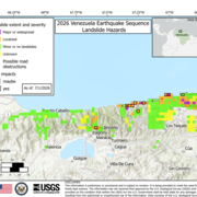
2026 Venezuela Sequence Earthquake-Triggered Landslide Hazards

2025 M7.0 Hubbard Glacier Earthquake-Triggered Landslides and Snow Avalanches
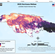
2025 Hurricane Melissa Landslide Hazards

Landslide Assessments, Situational Awareness, and Event Response Research (LASER)

Landslides Triggered by the 2020 Puerto Rico Earthquake Sequence

Global Earthquake-Triggered Ground Failure Inventory Database

Preliminary Analysis of Satellite Imagery and Seismic Observations of the Nuugaatsiaq Landslide and Tsunami, Greenland

Near Realtime Maps of Possible Earthquake-Triggered Landslides

An Interactive Web-based Application for Earthquake-triggered Ground Failure Inventories

Reconstruction of an Avalanche: The West Salt Creek Rock Avalanche
Science and Products
2026 Venezuela Sequence Earthquake-Triggered Landslide Hazards
2025 M7.0 Hubbard Glacier Earthquake-Triggered Landslides and Snow Avalanches
2025 Hurricane Melissa Landslide Hazards
Landslide Assessments, Situational Awareness, and Event Response Research (LASER)
Landslides Triggered by the 2020 Puerto Rico Earthquake Sequence
Global Earthquake-Triggered Ground Failure Inventory Database
Preliminary Analysis of Satellite Imagery and Seismic Observations of the Nuugaatsiaq Landslide and Tsunami, Greenland
Near Realtime Maps of Possible Earthquake-Triggered Landslides
An Interactive Web-based Application for Earthquake-triggered Ground Failure Inventories