
"How far will debris flows travel?"
Understanding how far debris flows can travel and what the impacts may be is one of the most important questions we face to effectively protect life and property from debris-flow hazards.
Debris-flow Runout Mapping
Postfire debris flows often begin in steep burned watersheds and can move rapidly downstream, sometimes traveling far beyond the burn perimeter into flat terrain. When these flows reach developed areas, they can cause widespread damage to homes, roads, and infrastructure and may pose a threat to life and safety.
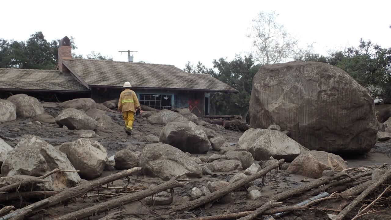
To help communities prepare for postfire hazards, the U.S. Geological Survey produces debris-flow hazard assessments and maps that support emergency management and postfire planning. A method published in 2026 now allows the USGS to produce debris-flow runout maps, which show where debris flows may travel within and beyond burned areas.
These maps are not created for every fire, but they are an important tool for predicting where debris flows may travel in areas where downstream communities, roads, and other infrastructure are at risk.
Learn more about postfire debris-flow hazard assessments and how to request an assessment here.
Runout Assessment Data
-
Post-Wildfire Debris-Flow Runout Hazard Assessment (PWFDF-R) Collection (updated 20260423) Post-Wildfire Debris-Flow Runout Hazard Assessment (PWFDF-R) Collection (updated 20260423)
Wildfire can substantially alter the hydrologic response of watersheds to rainfall, and debris-flow activity is among the most destructive consequences of these events. To assist federal, state, and local agencies in planning for postfire hazards, the U.S. Geological Survey conducts debris-flow hazard runout assessments. This collection contains the results of those assessments conducted...
Important Publications
-
Multi-site evaluation of a postfire debris-flow runout forecast method Multi-site evaluation of a postfire debris-flow runout forecast method
Postfire debris flows pose a hazard to human life, property, and infrastructure when they travel from steep source areas to urbanized alluvial fans or other developed areas. Existing methods for rapid (Evaluation of debris-flow building damage forecasts Evaluation of debris-flow building damage forecasts
Reliable forecasts of building damage due to debris flows may provide situational awareness and guide land and emergency management decisions. Application of debris-flow runout models to generate such forecasts requires combining hazard intensity predictions with fragility functions that link hazard intensity with building damage. In this study, we evaluated the performance of building...Forecasting the inundation of postfire debris flows Forecasting the inundation of postfire debris flows
In the semi-arid regions of the western United States, postfire debris flows are typically runoff generated. The U.S. Geological Survey has been studying the mechanisms of postfire debris-flow initiation for multiple decades to generate operational models for forecasting the timing, location, and magnitude of postfire debris flows. Here we discuss challenges and progress for extending...Runout model evaluation based on back-calculation of building damage Runout model evaluation based on back-calculation of building damage
We evaluated the ability of three debris-flow runout models (RAMMS, FLO2D and D-Claw) to predict the number of damaged buildings in simulations of the 9 January 2019 Montecito, California, debris-flow event. Observations of building damage after the event were combined with OpenStreetMap building footprints to construct a database of all potentially impacted buildings. At the estimated...
Watch a video describing the runout mapping method
-
-

Multi-site evaluation of a postfire debris-flow runout forecast method
Postfire debris flows pose a hazard to human life, property, and infrastructure when they travel from steep source areas to urbanized alluvial fans or other developed areas. Existing methods for rapid (< 1 week) postfire debris-flow hazard assessment document the increase in the likelihood and size of debris flows as the magnitude of high-intensity rain necessary to initiate debris flows increases...
-
"How far will debris flows travel?"
Understanding how far debris flows can travel and what the impacts may be is one of the most important questions we face to effectively protect life and property from debris-flow hazards.
Debris-flow Runout Mapping
Postfire debris flows often begin in steep burned watersheds and can move rapidly downstream, sometimes traveling far beyond the burn perimeter into flat terrain. When these flows reach developed areas, they can cause widespread damage to homes, roads, and infrastructure and may pose a threat to life and safety.
To help communities prepare for postfire hazards, the U.S. Geological Survey produces debris-flow hazard assessments and maps that support emergency management and postfire planning. A method published in 2026 now allows the USGS to produce debris-flow runout maps, which show where debris flows may travel within and beyond burned areas.
These maps are not created for every fire, but they are an important tool for predicting where debris flows may travel in areas where downstream communities, roads, and other infrastructure are at risk.
Learn more about postfire debris-flow hazard assessments and how to request an assessment here.
Runout Assessment Data
-
Post-Wildfire Debris-Flow Runout Hazard Assessment (PWFDF-R) Collection (updated 20260423) Post-Wildfire Debris-Flow Runout Hazard Assessment (PWFDF-R) Collection (updated 20260423)
Wildfire can substantially alter the hydrologic response of watersheds to rainfall, and debris-flow activity is among the most destructive consequences of these events. To assist federal, state, and local agencies in planning for postfire hazards, the U.S. Geological Survey conducts debris-flow hazard runout assessments. This collection contains the results of those assessments conducted...
Important Publications
-
Multi-site evaluation of a postfire debris-flow runout forecast method Multi-site evaluation of a postfire debris-flow runout forecast method
Postfire debris flows pose a hazard to human life, property, and infrastructure when they travel from steep source areas to urbanized alluvial fans or other developed areas. Existing methods for rapid (Evaluation of debris-flow building damage forecasts Evaluation of debris-flow building damage forecasts
Reliable forecasts of building damage due to debris flows may provide situational awareness and guide land and emergency management decisions. Application of debris-flow runout models to generate such forecasts requires combining hazard intensity predictions with fragility functions that link hazard intensity with building damage. In this study, we evaluated the performance of building...Forecasting the inundation of postfire debris flows Forecasting the inundation of postfire debris flows
In the semi-arid regions of the western United States, postfire debris flows are typically runoff generated. The U.S. Geological Survey has been studying the mechanisms of postfire debris-flow initiation for multiple decades to generate operational models for forecasting the timing, location, and magnitude of postfire debris flows. Here we discuss challenges and progress for extending...Runout model evaluation based on back-calculation of building damage Runout model evaluation based on back-calculation of building damage
We evaluated the ability of three debris-flow runout models (RAMMS, FLO2D and D-Claw) to predict the number of damaged buildings in simulations of the 9 January 2019 Montecito, California, debris-flow event. Observations of building damage after the event were combined with OpenStreetMap building footprints to construct a database of all potentially impacted buildings. At the estimated...
Watch a video describing the runout mapping method
-
-
Multi-site evaluation of a postfire debris-flow runout forecast method
Postfire debris flows pose a hazard to human life, property, and infrastructure when they travel from steep source areas to urbanized alluvial fans or other developed areas. Existing methods for rapid (< 1 week) postfire debris-flow hazard assessment document the increase in the likelihood and size of debris flows as the magnitude of high-intensity rain necessary to initiate debris flows increases...
-