
Portage Glacier (right), Burns Glacier (center), Shakespeare Glacier (left) in Southcentral Alaska from the air.
Images
Browse images from a wide range of science topics covered by USGS.
Filter Total Items: 901

Portage, Burns and Shakespeare glaciers in Southcentral Alaska
Portage Glacier (right), Burns Glacier (center), Shakespeare Glacier (left) in Southcentral Alaska from the air.

Yukon Delta
After beginning in northern British Columbia and flowing through Yukon in Canada, the Yukon River crosses Alaska, USA, before emptying into the Bering Sea. Countless lakes, sloughs, and ponds are scattered throughout this scene of the Yukon Delta. The river's sinuous, branching waterways seem like blood vessels branching out to enclose an organ.
After beginning in northern British Columbia and flowing through Yukon in Canada, the Yukon River crosses Alaska, USA, before emptying into the Bering Sea. Countless lakes, sloughs, and ponds are scattered throughout this scene of the Yukon Delta. The river's sinuous, branching waterways seem like blood vessels branching out to enclose an organ.

A sunset seen from Kaktovik, Alaska
A sunset seen from Kaktovik, Alaska
A sunset seen from Kaktovik, Alaska

Beach seining on the Yukon River Delta
Jason Baker and Scott McLean pulling a beach seine in a side channel of the Yukon River
Jason Baker and Scott McLean pulling a beach seine in a side channel of the Yukon River

Von Karman Vortices
As air flows over and around objects in its path, spiraling eddies, known as Von Karman vortices, may form. The vortices in this image were created when prevailing winds sweeping east across the northern Pacific Ocean encountered Alaska's Aleutian Islands.
As air flows over and around objects in its path, spiraling eddies, known as Von Karman vortices, may form. The vortices in this image were created when prevailing winds sweeping east across the northern Pacific Ocean encountered Alaska's Aleutian Islands.

Alaska Mountain Range
Alaska mountain range.
Alaska mountain range.

Alaska Mountain Range
Alaska mountain range.
Alaska mountain range.

Alaska Scenic View
Scenic view of Alaskan lake and mountains.
Scenic view of Alaskan lake and mountains.

Kamchatka Peninsula
The eastern side of Russia's Kamchatka Peninsula juts into the Pacific Ocean west of Alaska. In this winter image, a volcanic terrain is hidden under snow-covered peaks and valley glaciers feed blue ice into coastal waters.
The eastern side of Russia's Kamchatka Peninsula juts into the Pacific Ocean west of Alaska. In this winter image, a volcanic terrain is hidden under snow-covered peaks and valley glaciers feed blue ice into coastal waters.

Fortress Mountain Formation, Brooks Range
View southward from Fortress Mountain Formation on Atigun syncline towards Brooks Range. Trans-Alaska Pipeline, haul road, and Galbraith Lake in valley. Location in Brooks Range foothills, about 90 miles southeast of Umiat.
View southward from Fortress Mountain Formation on Atigun syncline towards Brooks Range. Trans-Alaska Pipeline, haul road, and Galbraith Lake in valley. Location in Brooks Range foothills, about 90 miles southeast of Umiat.

Polar bear mother and two cubs on the Beaufort Sea ice
Polar bear mother and two cubs on the Beaufort Sea ice.
Polar bear mother and two cubs on the Beaufort Sea ice.

Malaspina Glacier
The tongue of the Malaspina Glacier, the largest glacier in Alaska, fills most of this image. The Malaspina lies west of Yakutat Bay and covers 1,500 sq mi (3,880 sq km).
The tongue of the Malaspina Glacier, the largest glacier in Alaska, fills most of this image. The Malaspina lies west of Yakutat Bay and covers 1,500 sq mi (3,880 sq km).

Aleutian Clouds
These cloud formations were seen over the western Aleutian Islands. Their color variations are probably due to differences in temperature and in the size of water droplets that make up the clouds.
These cloud formations were seen over the western Aleutian Islands. Their color variations are probably due to differences in temperature and in the size of water droplets that make up the clouds.

John Wild River, near Anaktuvuk
Looking upstream from mid channel of the John Wild River. Near Anaktuvuk, Alaska.
Looking upstream from mid channel of the John Wild River. Near Anaktuvuk, Alaska.


Yukon Delta
An intricate maze of small lakes and waterways define the Yukon Delta at the confluence of Alaska's Yukon and Kuskokwim Rivers with the frigid Bering Sea. Wildlife abounds on the delta and offshore where sheets of sea ice form during the coldest months of the year.
An intricate maze of small lakes and waterways define the Yukon Delta at the confluence of Alaska's Yukon and Kuskokwim Rivers with the frigid Bering Sea. Wildlife abounds on the delta and offshore where sheets of sea ice form during the coldest months of the year.

Valley of Ten Thousand Smokes, Alaska
View southeast from Overlook Cabin looking over the Valley of Ten Thousand Smokes. The pyroclastic and ash deposits that fill the valley remain nearly vegetation-free more than 100 years after the 1912 Novarupta-Katmai eruption.
View southeast from Overlook Cabin looking over the Valley of Ten Thousand Smokes. The pyroclastic and ash deposits that fill the valley remain nearly vegetation-free more than 100 years after the 1912 Novarupta-Katmai eruption.

Tule white-fronted goose in the Kahiltna Valley, Alaska, in 1984
Tule white-fronted goose in the Kahiltna Valley, Alaska, in 1984.
Tule white-fronted goose in the Kahiltna Valley, Alaska, in 1984.
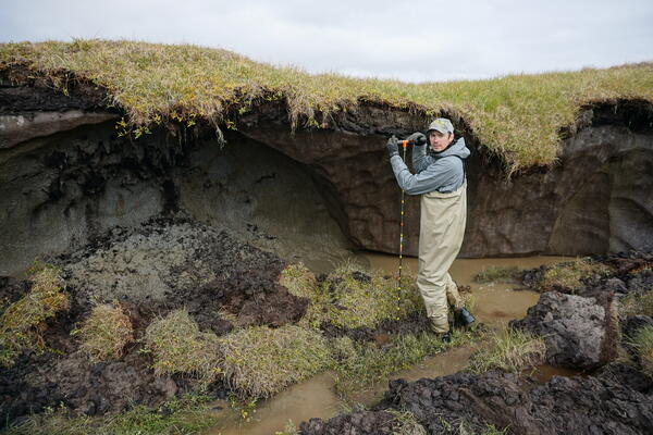
Allen Bondurant measuring depth to permafrost along a thermokarst lake shore
Allen Bondurant measuring depth to permafrost along a thermokarst lake shore
Allen Bondurant measuring depth to permafrost along a thermokarst lake shore
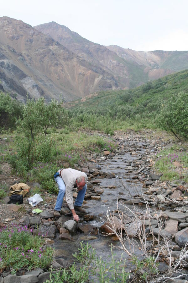
Sampling Stream Water in Denali National Park, Alaska
Ed Pfeifer of the USGS Southwest Geographic Science Team collecting water samples during field work for a study of Dall sheep habitat in Denali National Park, Alaska.
Ed Pfeifer of the USGS Southwest Geographic Science Team collecting water samples during field work for a study of Dall sheep habitat in Denali National Park, Alaska.
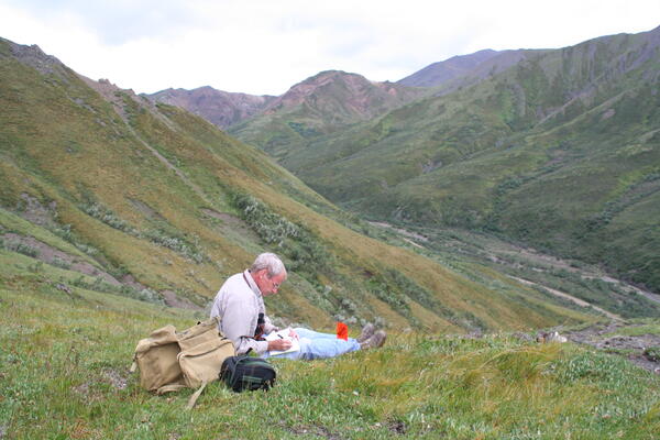
Dall Sheep Habitat, Denali National Park, Alaska
Ed Pfeifer of the USGS Southwest Geographic Science Team recording field notes in alpine tundra during a field study of Dall sheep habitat in Denali National Park, Alaska, on July 29, 2009
Ed Pfeifer of the USGS Southwest Geographic Science Team recording field notes in alpine tundra during a field study of Dall sheep habitat in Denali National Park, Alaska, on July 29, 2009