A stream winding through polygonal ground on the Arctic Coastal Plain
A stream winding through polygonal ground on the Arctic Coastal PlainA stream winding through polygonal ground on the Arctic Coastal Plain

Official websites use .gov
A .gov website belongs to an official government organization in the United States.
Secure .gov websites use HTTPS
A lock () or https:// means you’ve safely connected to the .gov website. Share sensitive information only on official, secure websites.
Browse images from a wide range of science topics covered by USGS.

A stream winding through polygonal ground on the Arctic Coastal Plain
A stream winding through polygonal ground on the Arctic Coastal Plain
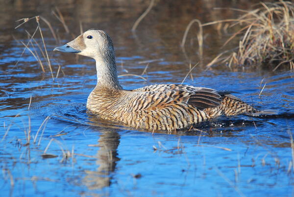
Spectacled Eiders nest along Arctic coasts of Alaska and Russia and on the Yukon-Kuskokwim Delta in Alaska. Spectacled eiders arrive on the breeding grounds as pairs in late-May or in June.
Spectacled Eiders nest along Arctic coasts of Alaska and Russia and on the Yukon-Kuskokwim Delta in Alaska. Spectacled eiders arrive on the breeding grounds as pairs in late-May or in June.

Researchers collect water chemistry and invertebrates from a degrading trough pond.
Researchers collect water chemistry and invertebrates from a degrading trough pond.

Female Western Sandpiper. This photo was taken on the Seward Peninsula as part of the Changing Arctic Ecosystem Boreal-Arctic Transition Zone program.
Female Western Sandpiper. This photo was taken on the Seward Peninsula as part of the Changing Arctic Ecosystem Boreal-Arctic Transition Zone program.

A Short-tailed Albatross on the water
A Short-tailed Albatross on the water

Short-tailed Albatross taking off
Short-tailed Albatross taking off
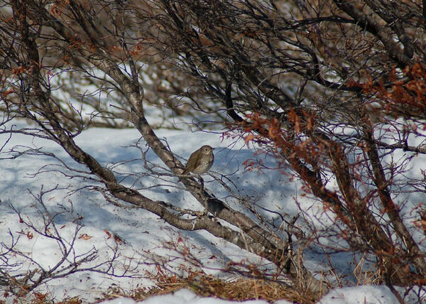
A Gray-cheeked Thrush perched in a shrub. This photo was taken on the Seward Peninsula as part of the Changing Arctic Ecosystem Boreal-Arctic Transition Zone program.
A Gray-cheeked Thrush perched in a shrub. This photo was taken on the Seward Peninsula as part of the Changing Arctic Ecosystem Boreal-Arctic Transition Zone program.
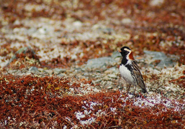
Male Lapland Longspur in the tundra. This photo was taken on the Seward Peninsula as part of the Changing Arctic Ecosystem Boreal-Arctic Transition Zone program.
Male Lapland Longspur in the tundra. This photo was taken on the Seward Peninsula as part of the Changing Arctic Ecosystem Boreal-Arctic Transition Zone program.

An aerial view of sea ice with open water from a helicopter in the Beaufort Sea. Photo taken during Spring Capture of the Polar Bear project.
An aerial view of sea ice with open water from a helicopter in the Beaufort Sea. Photo taken during Spring Capture of the Polar Bear project.

An aerial view of sea ice with open water from a helicopter in the Beaufort Sea. Photo taken during Spring Capture of the Polar Bear project.
An aerial view of sea ice with open water from a helicopter in the Beaufort Sea. Photo taken during Spring Capture of the Polar Bear project.

An aerial view of sea ice with open water from a helicopter in the Beaufort Sea. Photo taken during Spring Capture of the Polar Bear project.
An aerial view of sea ice with open water from a helicopter in the Beaufort Sea. Photo taken during Spring Capture of the Polar Bear project.

An aerial view of sea ice with open water from a helicopter in the Beaufort Sea. Photo taken during Spring Capture of the Polar Bear project.
An aerial view of sea ice with open water from a helicopter in the Beaufort Sea. Photo taken during Spring Capture of the Polar Bear project.

An aerial view of sea ice with open water from a helicopter in the Beaufort Sea. Photo taken during Spring Capture of the Polar Bear project.
An aerial view of sea ice with open water from a helicopter in the Beaufort Sea. Photo taken during Spring Capture of the Polar Bear project.

Caribou from the Central Arctic herd along the Sagavanirktok River in northern Alaska.
Sagavanirktok River, AK.
Caribou from the Central Arctic herd along the Sagavanirktok River in northern Alaska.
Sagavanirktok River, AK.

Caribou from the Central Arctic herd along the Sagavanirktok River in northern Alaska.
Sagavanirktok River, AK.
Caribou from the Central Arctic herd along the Sagavanirktok River in northern Alaska.
Sagavanirktok River, AK.

An aerial view of sea ice with open water from a helicopter in the Beaufort Sea. Photo taken during Spring Capture of the Polar Bear project.
An aerial view of sea ice with open water from a helicopter in the Beaufort Sea. Photo taken during Spring Capture of the Polar Bear project.

An aerial view of sea ice with open water from a helicopter in the Beaufort Sea. Photo taken during Spring Capture of the Polar Bear project.
An aerial view of sea ice with open water from a helicopter in the Beaufort Sea. Photo taken during Spring Capture of the Polar Bear project.

A polar bear is being subjected to the enhanced sampling protocol for suspected alopecic bears. In the photo, we're using the tape measure to demonstrate the size of the area of hair loss on the neck. This photo was taken on the sea ice north of Utqiagvik, Alaska.
A polar bear is being subjected to the enhanced sampling protocol for suspected alopecic bears. In the photo, we're using the tape measure to demonstrate the size of the area of hair loss on the neck. This photo was taken on the sea ice north of Utqiagvik, Alaska.

Epigenetic ice wedge exposed along the Beaufort Sea coast. This ice wedge is formed in ice-rich silt. The location is west of Point Lonely, Alaska.
Epigenetic ice wedge exposed along the Beaufort Sea coast. This ice wedge is formed in ice-rich silt. The location is west of Point Lonely, Alaska.

Reflections of Tanalian Mountain and Hardenburg Bay in Lake Clark, Alaska. Near Port Alsworth.
Reflections of Tanalian Mountain and Hardenburg Bay in Lake Clark, Alaska. Near Port Alsworth.
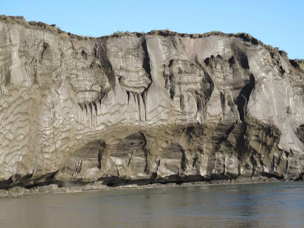
General view of a 35-meter-high riverbank exposure of the ice-rich syngenetic permafrost (yedoma) containing large ice wedges along the Itkillik River in northern Alaska. Copyright-free photo courtesy of Mikhail Kanevskiy; University of Alaska Fairbanks, Institute of Northern Engineering.
General view of a 35-meter-high riverbank exposure of the ice-rich syngenetic permafrost (yedoma) containing large ice wedges along the Itkillik River in northern Alaska. Copyright-free photo courtesy of Mikhail Kanevskiy; University of Alaska Fairbanks, Institute of Northern Engineering.