
...to informing restoration efforts in the Florida Everglades
...to tracking storm-related flood conditions through the South Atlantic...
...to investigating coral health in the Florida Keys & Caribbean...
...to assessing environmental contaminants on aquatic life in the Mississippi River Basin...
...USGS science spans the South Atlantic, Gulf States and Caribbean
The Southeast Region includes 13 states and two U.S. territories, Puerto Rico and the U.S. Virgin Islands
The Southeast Region includes 13 states and two U.S. territories, Puerto Rico and the U.S. Virgin Islands
Southeast Region
We conduct impartial, multi- and interdisciplinary research and monitoring to address a broad range of natural-resource issues that affect the quality of life of citizens and landscapes in the Southeastern United States and the Caribbean region.
News
Lithium in Eastern States Could Replace Imports for a Century or More
Lithium in Eastern States Could Replace Imports for a Century or More
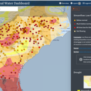
New Nationwide Tool Helps Answer: Do We Have Enough Water?
New Nationwide Tool Helps Answer: Do We Have Enough Water?
SPCMSC and University of Miami Scientists Collaborate on New Experiments to Guide National Park Service Coral Restoration Plans
SPCMSC and University of Miami Scientists Collaborate on New Experiments to Guide National Park Service Coral Restoration Plans
Publications
An automated geographic information system-based hydraulic modeling tool for developing preliminary culvert designs for stream crossings in Massachusetts An automated geographic information system-based hydraulic modeling tool for developing preliminary culvert designs for stream crossings in Massachusetts
Introduction Currently (2026), many of the about 25,000 roadway crossing structures over rivers and streams in Massachusetts are undersized. Undersized culverts and bridges can be detrimental to fish and wildlife movement, habitat continuity, and the health of aquatic organisms. Undersized culverts also can lack the resiliency needed to withstand large floods, which could be worsened by...
Assessment of long-term trends in streamflow statistics within and near the Mobile Bay and Perdido Bay watersheds, United States, 1950–2022 Assessment of long-term trends in streamflow statistics within and near the Mobile Bay and Perdido Bay watersheds, United States, 1950–2022
The U.S. Geological Survey, in cooperation with the Gulf Coast Ecosystem Restoration Council, assessed monotonic trends for a variety of streamflow statistics for 69 long-term U.S. Geological Survey streamgages within either the Mobile Bay or Perdido Bay watersheds that were active through at least at the end of calendar year 2019. Long-term data were defined for this investigation as...
GT-Seq panel development for species identification and parentage analysis of closely related hybridising Scaphirhynchus sturgeons GT-Seq panel development for species identification and parentage analysis of closely related hybridising Scaphirhynchus sturgeons
Hatchery supplementation is vital for conserving dwindling fish populations. Effective augmentation requires distinguishing hatchery-origin from wild individuals and accurately identifying species, particularly in systems where closely related species coexist. Genetic monitoring is key to quantifying genetic differences, but conventional markers do not distinguish hybrids, especially...
Science

Mobile River Basin Study
The Mobile River Basin in Alabama, Georgia, Mississippi, and Tennessee is one of the 59 study units that are part of the U.S. Geological Survey's National Water-Quality Assessment (NAWQA) Program. The long-term goals of this program are to describe the status and trends in the quality of a large, representative part of the Nation's surface- and ground-water resources, and to provide a sound...
South Atlantic Water Science Center Drought Monitoring
When rainfall is less than normal for several weeks, months, or years, the flow of streams and rivers declines, water levels in lakes and reservoirs fall, and the depth to water in wells increases. If dry weather persists and water-supply problems develop, the dry period can become a drought.

Triangle Area, NC, Water Supply Monitoring
The Research Triangle area, located within the upper Cape Fear and Neuse River basins, is one of the most rapidly developing areas in the Nation. Growth has increased demand for water from public suppliers, the majority of which draw water from streams and lakes in the region. Growth also brings the threat of greater loads of contaminants and new contaminant sources that, if not properly managed...