
Regional Assessments
Regional Assessments
Current regional water availability assessment basins
Regional Water Availability Assessments are scientific assessments of water availability in different hydrologic regions across the Nation. They are designed to capture a range of conditions in major drivers of water availability.
Filter Total Items: 8
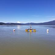
Integrating water availability in the Klamath Basin: from drought to dam removal
The USGS Water Resources Mission Area is assessing how much water is available for human and ecological needs in the United States and identifying where and when the Nation may have challenges meeting its demand for water. This information helps decision makers manage and distribute water in ways that balance competing needs. Due to its complex and competing water demands, ecological significance...

Saline Lake Ecosystems Integrated Water Availability Assessment
Increased water use, coupled with long-term drought conditions and a warming climate, have resulted in historic low water levels in saline lakes ecosystems across the Great Basin in California, Nevada, Oregon, and Utah. The Saline Lake Ecosystems IWAA is using an integrated scientific approach to monitor and assess water availability, migratory birds, and other wildlife dependent on saline lakes.

Regional Water Availability Assessment: Trinity-San Jacinto River Basin
The Trinity-San Jacinto River Basin studies will focus on evaluating the impacts of large urban environmental settings and high-impact weather events on water availability.

Regional Water Availability Assessment: Illinois River Basin
The Illinois River Basin is estimated to be one of the largest geographic sources of nutrients to the Gulf of America. Insights gained through study of this watershed can help improve understanding of how nutrient sources, in combination with climate- and land-use change, may limit water availability.

Mississippi Alluvial Plain (MAP) Regional Water Availability Study
Assessments of water availability in the Mississippi Alluvial Plain (MAP) region are critical for making well-informed management decisions about resource allocation and sustainability, establishing best practices for water use, and dealing with changes to the regional water cycle.

Integrated Water Science Basins: Willamette River
The Willamette River Basin reflects the conflicting water demands between humans and ecosystems—particularly salmon— and the challenge resource managers face throughout the Pacific Northwest.

Regional Water Availability Assessment: Upper Colorado River Basin
Regional Water Availability Assessments are scientific assessments of water availability in different hydrologic regions across the Nation. In the Upper Colorado River Basin, the USGS will conduct a focused assessment of how snowpack and snowmelt influence hydrology and water quality, and an integrated and comprehensive assessment of multiple water quantity, quality and use factors.

Regional Water Availability Assessment: Delaware River Basin
Regional Water Availability Assessments are scientific assessments of water availability in different hydrologic regions across the Nation. In the Delaware River Basin, the USGS will conduct a focused assessment of increasing freshwater salinity and an integrated and comprehensive assessment of multiple water quantity, quality and use factors.