
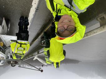
USGS hydrologist Patrick Haluska prepares to collect side-scan sonar data as part of the Klamath Integrated Water Availability Assessments program's dam removal studies.
Integrating water availability in the Klamath Basin: from drought to dam removal
Active
By Water Resources Mission Area
July 30, 2025
The USGS Water Resources Mission Area is assessing how much water is available for human and ecological needs in the United States and identifying where and when the Nation may have challenges meeting its demand for water. This information helps decision makers manage and distribute water in ways that balance competing needs. Due to its complex and competing water demands, ecological significance, and ongoing water management challenges, the Klamath Basin was selected for the Integrated Water Availability Assessments (IWAAs) program.
Media
Sources/Usage: Public Domain. View Media Details
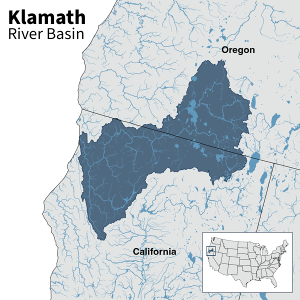
The Klamath Basin spans southern Oregon and northern California. Home to the Klamath, Yurok, Karuk, and Hoopa Valley Tribes. The Klamath Basin features wetlands, forests, and agricultural lands. The Klamath River is fed by numerous tributaries and groundwater. These sources contribute to the river's flow as it moves from Upper Klamath Lake in Oregon to the Pacific Ocean in California. In 2024, a Tribal-led effort completed the removal of four large dams on the Klamath River—the largest dam removal in U.S. history. Removing the aging dams was intended to improve fish migration and river health, but tensions persist among Tribal water rights, Federal water management, and agricultural water demands. Ongoing challenges throughout the region include water allocation conflicts, declining salmon and sucker populations, drought, changes in climate, and poor water quality from nutrients and algal blooms.
USGS is using an integrated science approach to evaluate water availability and support water management decisions in the Klamath Basin. Water availability refers to how much water is physically accessible (water quantity) and whether that water is safe to use (water quality). The Klamath Basin IWAAs program uses a variety of methods and approaches to determine:
- Controls on water availability in the Upper Klamath Basin
- Effects of dam removal on sediment transport, river shape, and habitat downstream
- Linkages of water availability between upper and lower basins following dam removal
Media
Sources/Usage: Public Domain. View Media Details
Controls on water availability in the upper Klamath Basin
Drought, agriculture, and the need to protect endangered species have long strained water availability in the Klamath Basin, impacting both the economy and the environment. The USGS is working to reduce uncertainties in the basin’s water budget (the difference between water supply and demand) by building on past research and identifying critical information gaps. The water budget analysis focuses on groundwater and surface water interactions in the Williamson River Basin, one of the Klamath River’s largest tributaries. Understanding the basin’s water budget includes identifying where groundwater recharge occurs and how it sustains streamflow.
By monitoring and analyzing key water budget components, the USGS is identifying factors that affect water availability throughout the basin. This information helps decision makers predict the effects of drought and other changes on both people and ecosystems.
Dam removal effects on Klamath River ecosystems
The removal of the four dams on the Klamath River created new river conditions that affect water quality, sediment transport (the movement of soil and rock particles), and geomorphology (the formation and evolution of landforms). Klamath Dam Removal studies focus on how the dam removal has affected sediment movement, river shape, and habitat downstream.
Before the dams were removed, USGS collected sediment and river channel data to establish baseline conditions in the Klamath River. Now, the USGS is tracking how the river responds to dam removal, focusing on the large amounts of fine sediment released downstream. Researchers will compare conditions before dam removal (2018-2023) and after dam removal (2024-2026) to inform stakeholders on how the river is adjusting. Documenting these changes in the river post-dam removal helps determine any changes to aquatic habitat that could affect endangered fish. Developing new techniques to assess these changes could be used in future dam removal research.

Sources/Usage: Public Domain. View Media Details
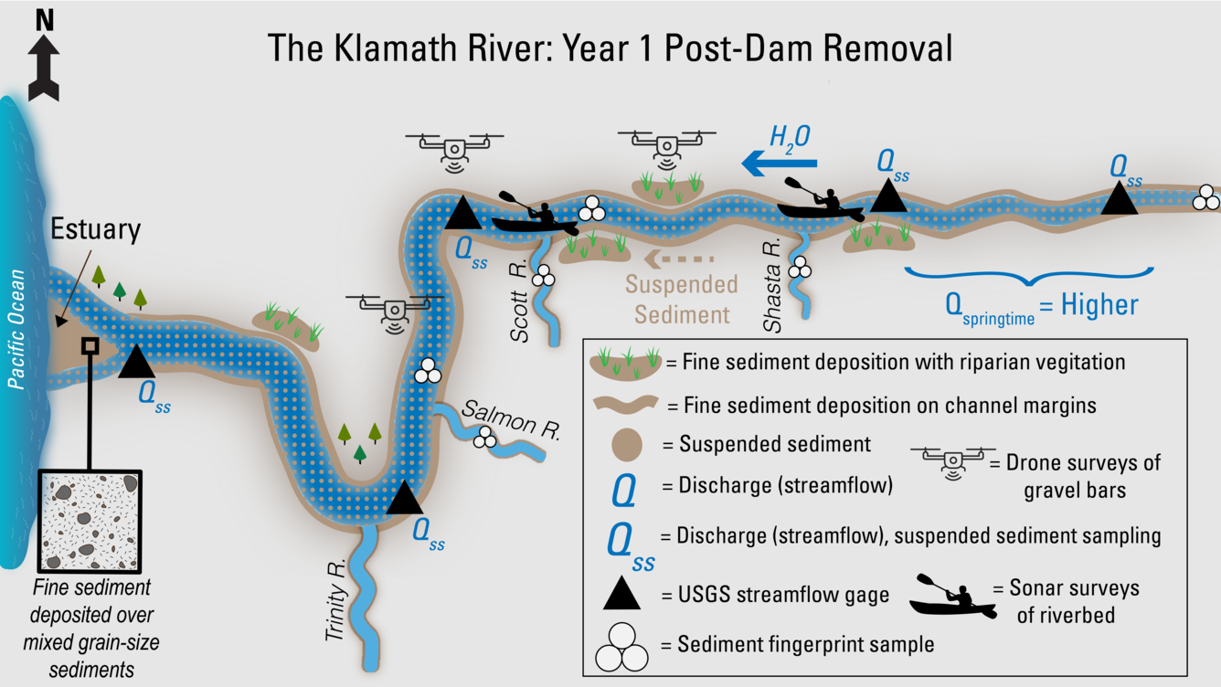
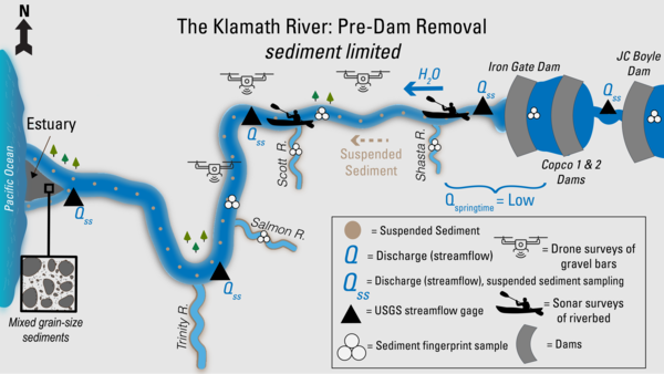
Before image: This illustration shows USGS work on the Klamath River and its main tributaries before the dams were removed. Iron Gate, Copco 1 and 2, and JC Boyle Dams blocked the river’s flow and trapped sediment. As a result, only small amounts of suspended sediment made it downstream, and springtime flows were low. USGS measured streamflow and sediment at gaging stations along the river and tributaries. Scientists also collected sediment fingerprint samples from reservoirs, the main river, and the Salmon, Scott, and Shasta Rivers to trace sediment sources. Drones scanned gravel bars, and sonar from boats mapped the riverbed. At the river’s mouth, the bed sediment in the Klamath estuary had a mix of sediment sizes.
After image: This illustration shows USGS work during the first year after dam removal. With the dams gone, the Klamath River now flows freely in the former hydroelectric reach, releasing stored sediment. Large amounts of fine sediment move downstream, depositing along channel edges and gravel bars, where new vegetation can grow. Springtime flows are higher. USGS gages continue to track streamflow and suspended sediment. Sediment fingerprinting samples are still taken from the main river and the Salmon, Scott, and Shasta tributaries. Drones survey sediment-covered bars, and boats use sonar to map streambed changes underwater. At the estuary, mixed grain-sized sediment is now covered by a layer of fine material from upstream.
Media
Sources/Usage: Public Domain. View Media Details
Water availability linkages following dam removal
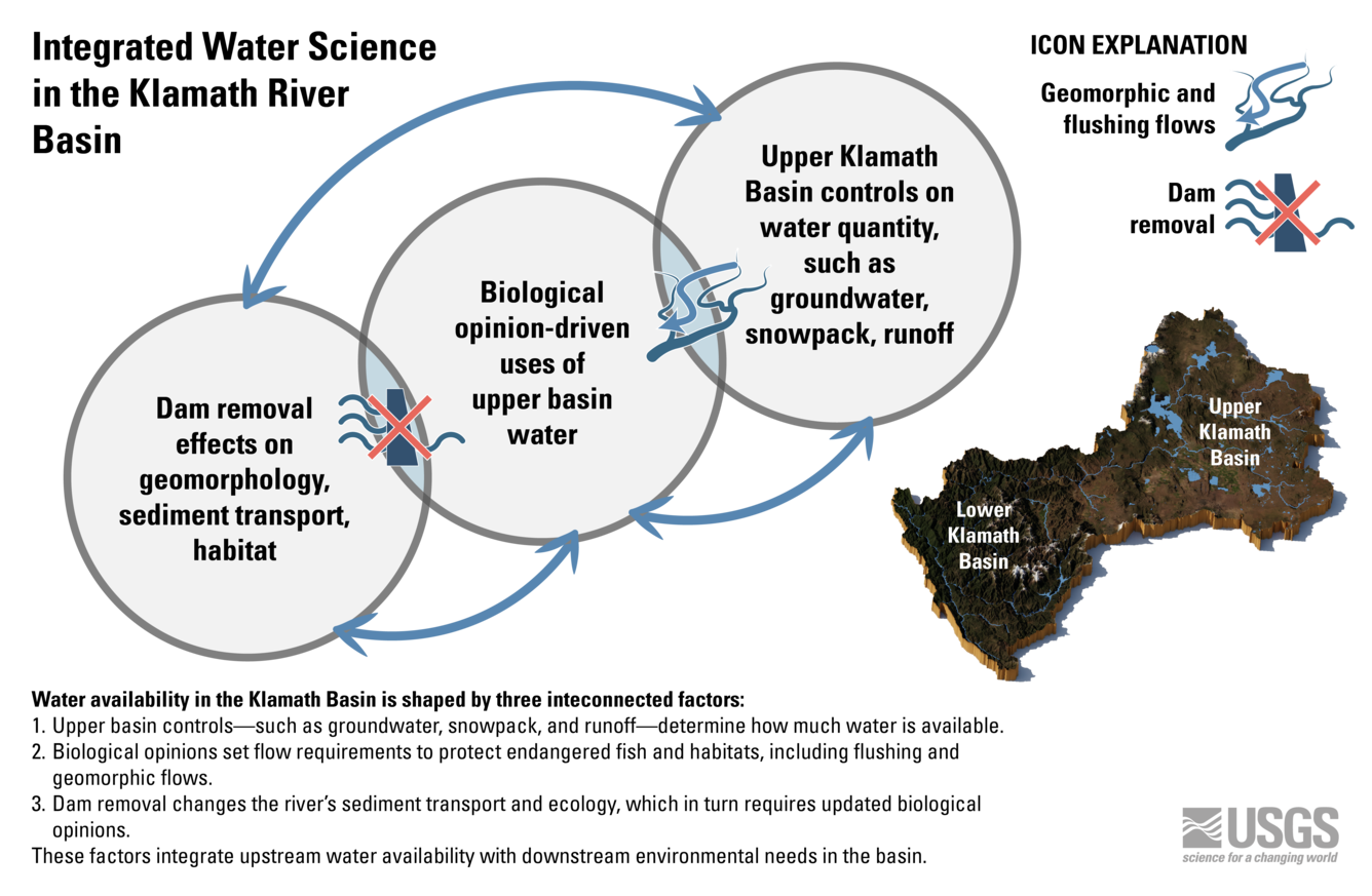
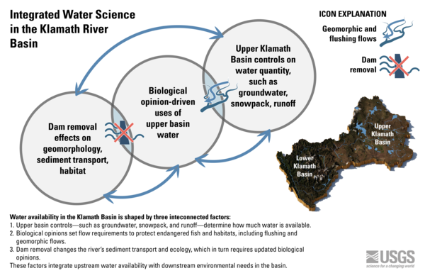
Water availability in the Lower Klamath Basin is linked to water availability in the Upper Klamath Basin, with upstream conditions directly affecting water management downstream (Fig.1). After the removal of the four dams, Federal agencies recommended a new flow regime for the Klamath River to better manage water availability for endangered salmon. Water management before dam removal included high streamflows to mobilize sediment below the dams to mitigate fish disease, also called "flushing" flows. Following dam removal, new managed flows, called "geomorphic" flows, are intended to move fine sediment from the removals, and could also change the amount of water available for irrigation depending on the seasonal streamflow patterns in any given year.
Water managers must balance the needs of Upper Klamath Lake, endangered species, and agriculture, but uncertainty in water supply predictions makes planning difficult. As competing water demands continue, water managers will need a whole-basin approach to effectively assess and distribute water resources in this changing river. USGS is enhancing existing monitoring efforts with airborne snowpack surveys, tall canopy evapotranspiration monitoring, and low-elevation remote sensing to support water supply predictions and inform water management decisions throughout the Klamath Basin.
Media
Sources/Usage: Public Domain. View Media Details

Integrated Water Availability Assessments
The USGS Water Resources Mission Area is assessing how much water is available for human and ecological needs in the United States and identifying where and when the Nation may have challenges meeting its demand for water.

Klamath Dam Removal Studies
The USGS is collecting continuous and discrete monitoring data to document baseline conditions and physical responses in downstream river reaches before, during, and after dam removal. These monitoring data will be integral for post-removal assessments and collaborations with basin partners.
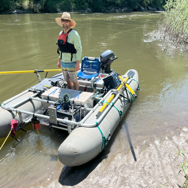
Klamath River sonar survey
USGS hydrologist Patrick Haluska prepares to collect side-scan sonar data as part of the Klamath Integrated Water Availability Assessments program's dam removal studies.
Klamath dam removal conceptual model
Before image: This illustration shows USGS work on the Klamath River and its main tributaries before the dams were removed. Iron Gate, Copco 1 and 2, and JC Boyle Dams blocked the river’s flow and trapped sediment. As a result, only small amounts of suspended sediment made it downstream, and springtime flows were low.
Before image: This illustration shows USGS work on the Klamath River and its main tributaries before the dams were removed. Iron Gate, Copco 1 and 2, and JC Boyle Dams blocked the river’s flow and trapped sediment. As a result, only small amounts of suspended sediment made it downstream, and springtime flows were low.
Integrated Water Science in the Klamath River Basin, Diagram
Integrated Water Science in the Klamath River Basin, DiagramWater availability in the Klamath Basin is shaped by three interconnected factors, like overlapping circles in a Venn diagram. First, upper basin controls—such as groundwater, snowpack, and runoff—determine how much water is available. Second, biological opinions set flow requirements to protect endangered fish and habitats, including flushing and geomorphic flows.
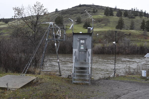
USGS Klamath River streamgage below Iron Gate
USGS streamgage 11516530 on the Klamath River below Iron Gate Dam in Siskiyou County, California, monitors real-time streamflow and water temperature for a 4,630-square-mile basin.
USGS streamgage 11516530 on the Klamath River below Iron Gate Dam in Siskiyou County, California, monitors real-time streamflow and water temperature for a 4,630-square-mile basin.
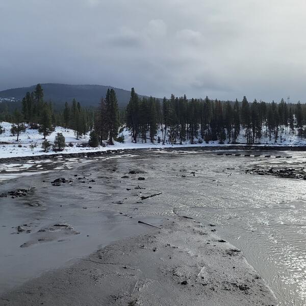
Klamath River during early dam removal
Starting January 2024, water levels behind the dams were gradually lowered over several weeks to prevent flooding and minimize downstream sediment impacts.
Starting January 2024, water levels behind the dams were gradually lowered over several weeks to prevent flooding and minimize downstream sediment impacts.
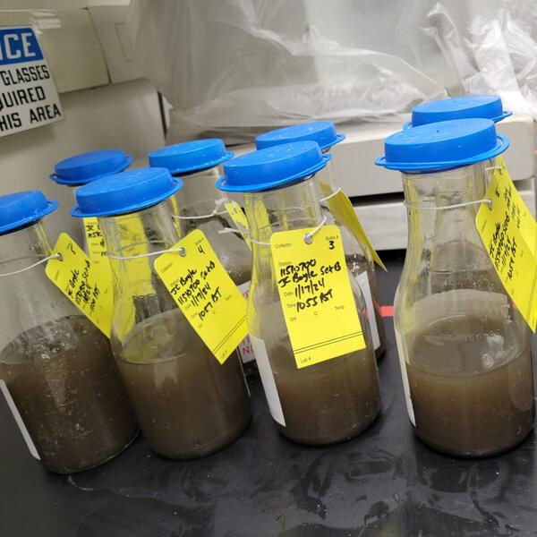
Sediment samples from the Klamath River near Keno
Sediment samples collected during reservoir drawdown on the Klamath River below where John C. Boyle Powerplant used to be near Keno, Oregon.
Sediment samples collected during reservoir drawdown on the Klamath River below where John C. Boyle Powerplant used to be near Keno, Oregon.
The USGS Water Resources Mission Area is assessing how much water is available for human and ecological needs in the United States and identifying where and when the Nation may have challenges meeting its demand for water. This information helps decision makers manage and distribute water in ways that balance competing needs. Due to its complex and competing water demands, ecological significance, and ongoing water management challenges, the Klamath Basin was selected for the Integrated Water Availability Assessments (IWAAs) program.
Media
Sources/Usage: Public Domain. View Media Details
The Klamath Basin spans southern Oregon and northern California. Home to the Klamath, Yurok, Karuk, and Hoopa Valley Tribes. The Klamath Basin features wetlands, forests, and agricultural lands. The Klamath River is fed by numerous tributaries and groundwater. These sources contribute to the river's flow as it moves from Upper Klamath Lake in Oregon to the Pacific Ocean in California. In 2024, a Tribal-led effort completed the removal of four large dams on the Klamath River—the largest dam removal in U.S. history. Removing the aging dams was intended to improve fish migration and river health, but tensions persist among Tribal water rights, Federal water management, and agricultural water demands. Ongoing challenges throughout the region include water allocation conflicts, declining salmon and sucker populations, drought, changes in climate, and poor water quality from nutrients and algal blooms.
USGS is using an integrated science approach to evaluate water availability and support water management decisions in the Klamath Basin. Water availability refers to how much water is physically accessible (water quantity) and whether that water is safe to use (water quality). The Klamath Basin IWAAs program uses a variety of methods and approaches to determine:
- Controls on water availability in the Upper Klamath Basin
- Effects of dam removal on sediment transport, river shape, and habitat downstream
- Linkages of water availability between upper and lower basins following dam removal
Media
Sources/Usage: Public Domain. View Media Details
Controls on water availability in the upper Klamath Basin
Drought, agriculture, and the need to protect endangered species have long strained water availability in the Klamath Basin, impacting both the economy and the environment. The USGS is working to reduce uncertainties in the basin’s water budget (the difference between water supply and demand) by building on past research and identifying critical information gaps. The water budget analysis focuses on groundwater and surface water interactions in the Williamson River Basin, one of the Klamath River’s largest tributaries. Understanding the basin’s water budget includes identifying where groundwater recharge occurs and how it sustains streamflow.
By monitoring and analyzing key water budget components, the USGS is identifying factors that affect water availability throughout the basin. This information helps decision makers predict the effects of drought and other changes on both people and ecosystems.
Dam removal effects on Klamath River ecosystems
The removal of the four dams on the Klamath River created new river conditions that affect water quality, sediment transport (the movement of soil and rock particles), and geomorphology (the formation and evolution of landforms). Klamath Dam Removal studies focus on how the dam removal has affected sediment movement, river shape, and habitat downstream.
Before the dams were removed, USGS collected sediment and river channel data to establish baseline conditions in the Klamath River. Now, the USGS is tracking how the river responds to dam removal, focusing on the large amounts of fine sediment released downstream. Researchers will compare conditions before dam removal (2018-2023) and after dam removal (2024-2026) to inform stakeholders on how the river is adjusting. Documenting these changes in the river post-dam removal helps determine any changes to aquatic habitat that could affect endangered fish. Developing new techniques to assess these changes could be used in future dam removal research.
Sources/Usage: Public Domain. View Media Details
Before image: This illustration shows USGS work on the Klamath River and its main tributaries before the dams were removed. Iron Gate, Copco 1 and 2, and JC Boyle Dams blocked the river’s flow and trapped sediment. As a result, only small amounts of suspended sediment made it downstream, and springtime flows were low. USGS measured streamflow and sediment at gaging stations along the river and tributaries. Scientists also collected sediment fingerprint samples from reservoirs, the main river, and the Salmon, Scott, and Shasta Rivers to trace sediment sources. Drones scanned gravel bars, and sonar from boats mapped the riverbed. At the river’s mouth, the bed sediment in the Klamath estuary had a mix of sediment sizes.
After image: This illustration shows USGS work during the first year after dam removal. With the dams gone, the Klamath River now flows freely in the former hydroelectric reach, releasing stored sediment. Large amounts of fine sediment move downstream, depositing along channel edges and gravel bars, where new vegetation can grow. Springtime flows are higher. USGS gages continue to track streamflow and suspended sediment. Sediment fingerprinting samples are still taken from the main river and the Salmon, Scott, and Shasta tributaries. Drones survey sediment-covered bars, and boats use sonar to map streambed changes underwater. At the estuary, mixed grain-sized sediment is now covered by a layer of fine material from upstream.
Media
Sources/Usage: Public Domain. View Media Details
Water availability linkages following dam removal
Water availability in the Lower Klamath Basin is linked to water availability in the Upper Klamath Basin, with upstream conditions directly affecting water management downstream (Fig.1). After the removal of the four dams, Federal agencies recommended a new flow regime for the Klamath River to better manage water availability for endangered salmon. Water management before dam removal included high streamflows to mobilize sediment below the dams to mitigate fish disease, also called "flushing" flows. Following dam removal, new managed flows, called "geomorphic" flows, are intended to move fine sediment from the removals, and could also change the amount of water available for irrigation depending on the seasonal streamflow patterns in any given year.
Water managers must balance the needs of Upper Klamath Lake, endangered species, and agriculture, but uncertainty in water supply predictions makes planning difficult. As competing water demands continue, water managers will need a whole-basin approach to effectively assess and distribute water resources in this changing river. USGS is enhancing existing monitoring efforts with airborne snowpack surveys, tall canopy evapotranspiration monitoring, and low-elevation remote sensing to support water supply predictions and inform water management decisions throughout the Klamath Basin.
Media
Sources/Usage: Public Domain. View Media Details
Integrated Water Availability Assessments
The USGS Water Resources Mission Area is assessing how much water is available for human and ecological needs in the United States and identifying where and when the Nation may have challenges meeting its demand for water.
Klamath Dam Removal Studies
The USGS is collecting continuous and discrete monitoring data to document baseline conditions and physical responses in downstream river reaches before, during, and after dam removal. These monitoring data will be integral for post-removal assessments and collaborations with basin partners.
Klamath River sonar survey
USGS hydrologist Patrick Haluska prepares to collect side-scan sonar data as part of the Klamath Integrated Water Availability Assessments program's dam removal studies.
USGS hydrologist Patrick Haluska prepares to collect side-scan sonar data as part of the Klamath Integrated Water Availability Assessments program's dam removal studies.
Klamath dam removal conceptual model
Before image: This illustration shows USGS work on the Klamath River and its main tributaries before the dams were removed. Iron Gate, Copco 1 and 2, and JC Boyle Dams blocked the river’s flow and trapped sediment. As a result, only small amounts of suspended sediment made it downstream, and springtime flows were low.
Before image: This illustration shows USGS work on the Klamath River and its main tributaries before the dams were removed. Iron Gate, Copco 1 and 2, and JC Boyle Dams blocked the river’s flow and trapped sediment. As a result, only small amounts of suspended sediment made it downstream, and springtime flows were low.
Integrated Water Science in the Klamath River Basin, Diagram
Integrated Water Science in the Klamath River Basin, DiagramWater availability in the Klamath Basin is shaped by three interconnected factors, like overlapping circles in a Venn diagram. First, upper basin controls—such as groundwater, snowpack, and runoff—determine how much water is available. Second, biological opinions set flow requirements to protect endangered fish and habitats, including flushing and geomorphic flows.
Integrated Water Science in the Klamath River Basin, Diagram
Integrated Water Science in the Klamath River Basin, DiagramWater availability in the Klamath Basin is shaped by three interconnected factors, like overlapping circles in a Venn diagram. First, upper basin controls—such as groundwater, snowpack, and runoff—determine how much water is available. Second, biological opinions set flow requirements to protect endangered fish and habitats, including flushing and geomorphic flows.
USGS Klamath River streamgage below Iron Gate
USGS streamgage 11516530 on the Klamath River below Iron Gate Dam in Siskiyou County, California, monitors real-time streamflow and water temperature for a 4,630-square-mile basin.
USGS streamgage 11516530 on the Klamath River below Iron Gate Dam in Siskiyou County, California, monitors real-time streamflow and water temperature for a 4,630-square-mile basin.
Klamath River during early dam removal
Starting January 2024, water levels behind the dams were gradually lowered over several weeks to prevent flooding and minimize downstream sediment impacts.
Starting January 2024, water levels behind the dams were gradually lowered over several weeks to prevent flooding and minimize downstream sediment impacts.
Sediment samples from the Klamath River near Keno
Sediment samples collected during reservoir drawdown on the Klamath River below where John C. Boyle Powerplant used to be near Keno, Oregon.
Sediment samples collected during reservoir drawdown on the Klamath River below where John C. Boyle Powerplant used to be near Keno, Oregon.