
Adam Stonewall
Adam Stonewall is a supervisory hydrologist and the surface water specialist at the USGS Oregon Water Science Center.
I have been a Hydrologist in the Oregon Water Science Center since 2001. My background is primarily in flood frequency analysis. I also have strong interest and/or experience in statistical testing for nonstationarity, climate change, monte-carlo simulations and nonparametric statistics.
Science and Products
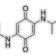
Monitoring tire-derived chemicals in stormwater
The USGS, in partnership with the Oregon Department of Transportation (ODOT) and other state and federal agencies, is studying a contaminant called 6PPD-quinone.

Modeling tire-derived chemicals in stormwater
The USGS and the Environmental Protection Agency are working together using advanced modeling tools to understand how 6PPD-quinone moves through watersheds and how green infrastructure can reduce its impact.
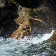
Tracking Tire Chemicals in Oregon Streams
The USGS studies 6PPD-quinone, a compound released from vehicle tires that can harm salmon and other fish. This research is part of a national effort to understand and mitigate stormwater pollution.

Effects of Highway Runoff on Water Quality
SELDM facilitates analysis by providing precipitation, pre-storm streamflow, and other variables by region or from hydrologically similar sites.
Groundwater Elevation and Temperature in Johnson Creek Basin
Water elevation and temperature in groundwater and Johnson Creek at Sycamore, near Portland, OR

Johnson Creek Basin Hydrologic Monitoring Study
The USGS provides hydrologic data for the Johnson Creek Basin. Real-time surface-water, water-quality and groundwater data, as well as historic data and analyses, help to improve our understanding of the hydrology of the basin.
Science and Products
Monitoring tire-derived chemicals in stormwater
The USGS, in partnership with the Oregon Department of Transportation (ODOT) and other state and federal agencies, is studying a contaminant called 6PPD-quinone.
Modeling tire-derived chemicals in stormwater
The USGS and the Environmental Protection Agency are working together using advanced modeling tools to understand how 6PPD-quinone moves through watersheds and how green infrastructure can reduce its impact.
Tracking Tire Chemicals in Oregon Streams
The USGS studies 6PPD-quinone, a compound released from vehicle tires that can harm salmon and other fish. This research is part of a national effort to understand and mitigate stormwater pollution.
Effects of Highway Runoff on Water Quality
SELDM facilitates analysis by providing precipitation, pre-storm streamflow, and other variables by region or from hydrologically similar sites.
Groundwater Elevation and Temperature in Johnson Creek Basin
Water elevation and temperature in groundwater and Johnson Creek at Sycamore, near Portland, OR
Johnson Creek Basin Hydrologic Monitoring Study
The USGS provides hydrologic data for the Johnson Creek Basin. Real-time surface-water, water-quality and groundwater data, as well as historic data and analyses, help to improve our understanding of the hydrology of the basin.