
Allison Sussman is a Biologist with the Remote Sensing and Geospatial Analysis Team (RSGAT) at the USGS Eastern Ecological Science Center in Laurel, MD.
Allison Sussman (Former Employee)
Science and Products

Marine Bird Populations and the Gulf of Mexico Marine Assessment Program for Protected Species (GoMMAPPS)
The objective of the Gulf of Mexico Marine Assessment for Protected Species (GoMMAPPS) project was to document the occurrence and diversity of bird species in nearshore and open sea environments of the Gulf of America for the purposes of better informing regulatory and other decisions that influence the conservation of migratory birds.

Communicating stream fish vulnerability to climate change
We will develop a vulnerability assessment R Shiny web application and present to stakeholders. The stakeholder feedback will be summarized into a one page ‘lessons learned’ document that will assist researchers in designing effective climate change visualizations and an R markdown ‘quick start’ guide on R Shiny applications.

Allison Sussman
Allison Sussman is a Biologist with the Remote Sensing and Geospatial Analysis Team (RSGAT) at the USGS Eastern Ecological Science Center in Laurel, MD.

GoMMAPPS Slideshow
Illustrations and photographs from the GoMMAPPS project, including fieldwork photos from 2018.
Illustrations and photographs from the GoMMAPPS project, including fieldwork photos from 2018.

GoMMAPPS Aerial Seabird Survey Design
Hexagon-based aerial survey design with transects overlaid. The EPA 40 km2 hexagons (White et al. 2018) were overlaid across the entirety of the northern Gulf of Mexico. Sampled hexagons were then selected using a Generalized Random Tesselation Stratified (GRTS) sampling scheme.
Hexagon-based aerial survey design with transects overlaid. The EPA 40 km2 hexagons (White et al. 2018) were overlaid across the entirety of the northern Gulf of Mexico. Sampled hexagons were then selected using a Generalized Random Tesselation Stratified (GRTS) sampling scheme.

Gulf Coast South of Lafayette, LA
View of the barrier islands off Lafayette, LA while conducting low-level aerial seabird surveys in the Gulf of Mexico, as part of the GoMMAPPS project.
View of the barrier islands off Lafayette, LA while conducting low-level aerial seabird surveys in the Gulf of Mexico, as part of the GoMMAPPS project.

Oil Platform
Oil platform in the Gulf of Mexico viewed as part of GoMMAPPS aerial surveys for seabirds.
Oil platform in the Gulf of Mexico viewed as part of GoMMAPPS aerial surveys for seabirds.
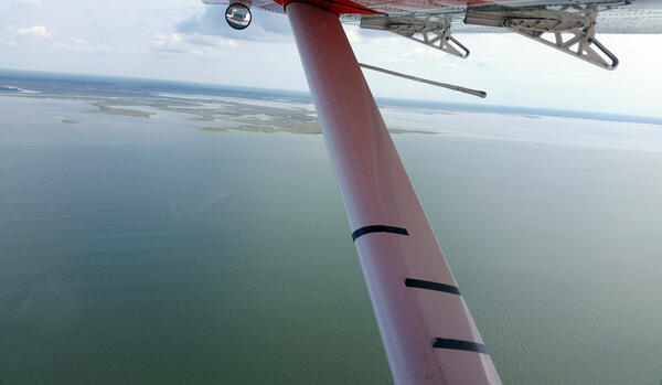
Aerial Survey Wing Markings
Standard wing markings on a US Fish and Wildlife Service Kodiak amphibious aircraft used to denote strip-transect distance bands to aid observers in data collection for the GoMMAPPS aerial seabird surveys from 2017-2020 and 2022-2023.
Standard wing markings on a US Fish and Wildlife Service Kodiak amphibious aircraft used to denote strip-transect distance bands to aid observers in data collection for the GoMMAPPS aerial seabird surveys from 2017-2020 and 2022-2023.

Aerial Survey Aircraft
US Fish and Wildlife Service Kodiak amphibious aircraft used in the GoMMAPPS aerial seabird surveys from 2017-2020 and 2022-2023.
US Fish and Wildlife Service Kodiak amphibious aircraft used in the GoMMAPPS aerial seabird surveys from 2017-2020 and 2022-2023.
GoMMAPPS Seabird Aerial Survey Protocol
Depiction of aerial survey design protocol showing strip-transect width and marked wing on aircraft.
Author: Allison Sussman, adapted from *Certain and Bretagnolle 2008
Depiction of aerial survey design protocol showing strip-transect width and marked wing on aircraft.
Author: Allison Sussman, adapted from *Certain and Bretagnolle 2008
Science and Products
Marine Bird Populations and the Gulf of Mexico Marine Assessment Program for Protected Species (GoMMAPPS)
The objective of the Gulf of Mexico Marine Assessment for Protected Species (GoMMAPPS) project was to document the occurrence and diversity of bird species in nearshore and open sea environments of the Gulf of America for the purposes of better informing regulatory and other decisions that influence the conservation of migratory birds.
Communicating stream fish vulnerability to climate change
We will develop a vulnerability assessment R Shiny web application and present to stakeholders. The stakeholder feedback will be summarized into a one page ‘lessons learned’ document that will assist researchers in designing effective climate change visualizations and an R markdown ‘quick start’ guide on R Shiny applications.
Allison Sussman
Allison Sussman is a Biologist with the Remote Sensing and Geospatial Analysis Team (RSGAT) at the USGS Eastern Ecological Science Center in Laurel, MD.
Allison Sussman is a Biologist with the Remote Sensing and Geospatial Analysis Team (RSGAT) at the USGS Eastern Ecological Science Center in Laurel, MD.
GoMMAPPS Slideshow
Illustrations and photographs from the GoMMAPPS project, including fieldwork photos from 2018.
Illustrations and photographs from the GoMMAPPS project, including fieldwork photos from 2018.
GoMMAPPS Aerial Seabird Survey Design
Hexagon-based aerial survey design with transects overlaid. The EPA 40 km2 hexagons (White et al. 2018) were overlaid across the entirety of the northern Gulf of Mexico. Sampled hexagons were then selected using a Generalized Random Tesselation Stratified (GRTS) sampling scheme.
Hexagon-based aerial survey design with transects overlaid. The EPA 40 km2 hexagons (White et al. 2018) were overlaid across the entirety of the northern Gulf of Mexico. Sampled hexagons were then selected using a Generalized Random Tesselation Stratified (GRTS) sampling scheme.
Gulf Coast South of Lafayette, LA
View of the barrier islands off Lafayette, LA while conducting low-level aerial seabird surveys in the Gulf of Mexico, as part of the GoMMAPPS project.
View of the barrier islands off Lafayette, LA while conducting low-level aerial seabird surveys in the Gulf of Mexico, as part of the GoMMAPPS project.
Oil Platform
Oil platform in the Gulf of Mexico viewed as part of GoMMAPPS aerial surveys for seabirds.
Oil platform in the Gulf of Mexico viewed as part of GoMMAPPS aerial surveys for seabirds.
Aerial Survey Wing Markings
Standard wing markings on a US Fish and Wildlife Service Kodiak amphibious aircraft used to denote strip-transect distance bands to aid observers in data collection for the GoMMAPPS aerial seabird surveys from 2017-2020 and 2022-2023.
Standard wing markings on a US Fish and Wildlife Service Kodiak amphibious aircraft used to denote strip-transect distance bands to aid observers in data collection for the GoMMAPPS aerial seabird surveys from 2017-2020 and 2022-2023.
Aerial Survey Aircraft
US Fish and Wildlife Service Kodiak amphibious aircraft used in the GoMMAPPS aerial seabird surveys from 2017-2020 and 2022-2023.
US Fish and Wildlife Service Kodiak amphibious aircraft used in the GoMMAPPS aerial seabird surveys from 2017-2020 and 2022-2023.
GoMMAPPS Seabird Aerial Survey Protocol
Depiction of aerial survey design protocol showing strip-transect width and marked wing on aircraft.
Author: Allison Sussman, adapted from *Certain and Bretagnolle 2008
Depiction of aerial survey design protocol showing strip-transect width and marked wing on aircraft.
Author: Allison Sussman, adapted from *Certain and Bretagnolle 2008