
Lenticular clouds form when moist air flows up the slopes of a volcano (or other peak), cools, and condenses. The resulting clouds often drop a bit after pushing over the summit, like an eddy over a rock in a stream, and create seemingly stationary shapes that hover over the landscape. USGS photo by Andrew Calvert.
Andrew Todd Calvert, Ph.D.
As a researcher, I decipher the eruptive history of young volcanoes through state-of-the-art age dating and geologic mapping.
Research Accomplishments
Eruptive history of Cascade and Aleutian Arc Volcanoes, an example from the Three Sisters
Most mapped volcanoes appear to be built episodically and characterizing these episodes offers insight into future eruptive behavior. Middle Sister is the most chemically diverse and youngest of the Three Sisters Volcanic Cluster (Hildreth et al., 2012). Dated, mapped lava flows precede and postdate the remarkably productive (fourfold increase in output between 50 – 15 thousand years) and silicic rhyolite episode best exposed at South Sister. Our Middle Sister paper (Calvert et al., 2018) chronicles mafic, intermediate and silicic eruptions from peripheral and central vents and compares timing and compositions with the largely-silicic products of South Sister (Fierstein et al., 2011).
Growth of Hawaiian volcanoes
Despite being some of the best-studied volcanoes on earth, little was known about the inception ages and lifespans of Hawaiian volcanoes, largely because early-erupted samples are inaccessible and all samples are difficult to date accurately and precisely. The chemical progression from alkalic to tholeiitic and back to alkalic compositions is well-characterized, yet the timescales of this variation have been difficult to constrain. Even volume estimates vary significantly because a new edifice may develop on the flank of an older shield. A collaborative agreement between USGS and the Japan Agency for Marine-Earth Science and Technology (JAMSTEC) provided submersible access to early-erupted materials and a unique opportunity to constrain inception ages and compositional evolution rates of the most productive volcanic center on earth.
We undertook to date submarine samples from the south flank of Kilauea, Mahukona and Hilo Ridge to develop a basic framework for the time-volume development of Hawaiian volcanoes. Lavas from an intact section of weakly alkalic basalts on submarine flank of Kilauea and strongly alkalic blocks from debris flows beneath Kilauea are indistinguishable at 147±14 ka and older strongly alkalic samples range from 212±38 ka to 280±20 ka (Calvert and Lanphere, 2006). This finding shows that Kilauea is a relatively young volcano and the voluminous younger, tholeiitic lavas were erupted at higher rates than generally assumed. This work refutes previous studies dating the tholeiitic lavas at 500 ka along the active rift zone and in drill core. Weakly-alkalic rocks from Hilo Ridge yielded 1150±20 ka ages, far too old to belong to their assumed source, Mauna Kea. Hilo Ridge instead belongs to Kohala volcano, which is now estimated to have erupted from 1,200 to 280 ka (Lipman and Calvert, 2011). Mauna Kea had been reported to be more voluminous than other centers on Hawaii, however, this result requires that the submarine Hilo Ridge belongs to Kohala, not Mauna Kea, reducing the estimated eruptive volume of Mauna Kea by nearly 50% (42 to 22 km3) a
Science and Products
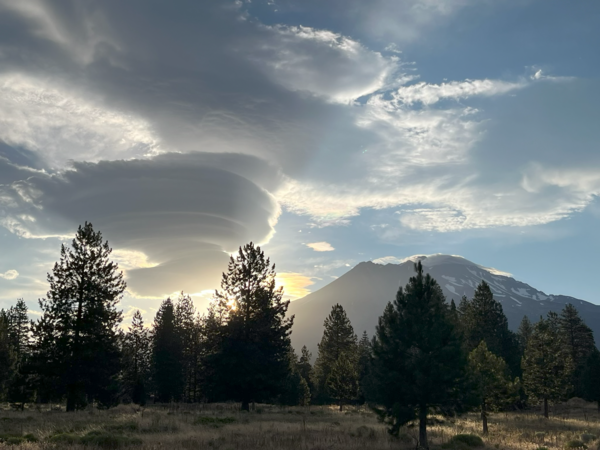
Lenticular clouds over Mount Shasta
Lenticular clouds form when moist air flows up the slopes of a volcano (or other peak), cools, and condenses. The resulting clouds often drop a bit after pushing over the summit, like an eddy over a rock in a stream, and create seemingly stationary shapes that hover over the landscape. USGS photo by Andrew Calvert.

Microscopic view of different groundmass textures in rocks
Microscopic view of different groundmass textures in rocksMicroscopic view of different groundmass textures in rocks. On the left, this groundmass is a good choice for argon dating, as it consists of abundant interconnected crystals. On the right, the groundmass consists predominantly of glass (black because it does not transmit cross-polarized light) and is a poor choice for argon dating.

Middle Sister volcano's east face with shingled stacks of thin lava...
Middle Sister volcano's east face with shingled stacks of thin lava...The east face of Middle Sister is 350 m (1150 ft) high. Ice-sculpted pile of lavas at right, variously called "Black Hump," "Prouty Point," or "Step Sister," has 190 m of relief and consists of at least five flows.
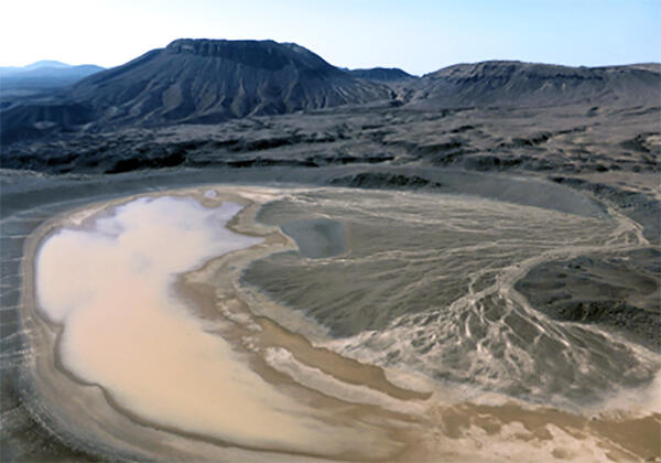
Um Junb lava dome, western Saudi Arabia
View south-southwest across maar crater of Gura 1 toward benmoreite lava dome and flow of Um Junb. Trachytic pyroclastic flow deposits of Gura 2 enter from upper right, mantling mugearite lava flow of Dabaa 1. Maar crater is about 0.7 kilometers across, and Um Junb stands about 250 meters above surroundings.
View south-southwest across maar crater of Gura 1 toward benmoreite lava dome and flow of Um Junb. Trachytic pyroclastic flow deposits of Gura 2 enter from upper right, mantling mugearite lava flow of Dabaa 1. Maar crater is about 0.7 kilometers across, and Um Junb stands about 250 meters above surroundings.

Mount Shasta, CA
Aerial photo of Mount Shasta's southwestern flank in a low-snow period. The Hotlum cone is on the right, while the Shastina dome is to the left.
Aerial photo of Mount Shasta's southwestern flank in a low-snow period. The Hotlum cone is on the right, while the Shastina dome is to the left.
Science and Products
Lenticular clouds over Mount Shasta
Lenticular clouds form when moist air flows up the slopes of a volcano (or other peak), cools, and condenses. The resulting clouds often drop a bit after pushing over the summit, like an eddy over a rock in a stream, and create seemingly stationary shapes that hover over the landscape. USGS photo by Andrew Calvert.
Lenticular clouds form when moist air flows up the slopes of a volcano (or other peak), cools, and condenses. The resulting clouds often drop a bit after pushing over the summit, like an eddy over a rock in a stream, and create seemingly stationary shapes that hover over the landscape. USGS photo by Andrew Calvert.
Microscopic view of different groundmass textures in rocks
Microscopic view of different groundmass textures in rocksMicroscopic view of different groundmass textures in rocks. On the left, this groundmass is a good choice for argon dating, as it consists of abundant interconnected crystals. On the right, the groundmass consists predominantly of glass (black because it does not transmit cross-polarized light) and is a poor choice for argon dating.
Middle Sister volcano's east face with shingled stacks of thin lava...
Middle Sister volcano's east face with shingled stacks of thin lava...The east face of Middle Sister is 350 m (1150 ft) high. Ice-sculpted pile of lavas at right, variously called "Black Hump," "Prouty Point," or "Step Sister," has 190 m of relief and consists of at least five flows.
Um Junb lava dome, western Saudi Arabia
View south-southwest across maar crater of Gura 1 toward benmoreite lava dome and flow of Um Junb. Trachytic pyroclastic flow deposits of Gura 2 enter from upper right, mantling mugearite lava flow of Dabaa 1. Maar crater is about 0.7 kilometers across, and Um Junb stands about 250 meters above surroundings.
View south-southwest across maar crater of Gura 1 toward benmoreite lava dome and flow of Um Junb. Trachytic pyroclastic flow deposits of Gura 2 enter from upper right, mantling mugearite lava flow of Dabaa 1. Maar crater is about 0.7 kilometers across, and Um Junb stands about 250 meters above surroundings.
Mount Shasta, CA
Aerial photo of Mount Shasta's southwestern flank in a low-snow period. The Hotlum cone is on the right, while the Shastina dome is to the left.
Aerial photo of Mount Shasta's southwestern flank in a low-snow period. The Hotlum cone is on the right, while the Shastina dome is to the left.