
A fluorite-lepidolite-wolframite vein intersected in drill core from the Lost River Sn-W mine, Seward Peninsula, Alaska. Lepidolite is a lithium-bearing mica, and wolframite an ore of tungsten.
George Case
George is a Research Economic Geologist for the Alaska Science Center.
He received a BSc from West Virginia University in 2012 and a PhD from James Cook University in 2017, focusing on iron oxide-copper-gold deposits. Since then, his work has shifted to studying other types of critical mineral ore-forming systems, including those that form graphite and lithium deposits. George utilizes a range of tools, from geochemistry to geochronology, to understand the genesis of mineral systems and apply that understanding to mapping and assessing resource potential for critical minerals in time and space.
Science and Products

Alaska Critical Mineral Resource Assessments
Alaska has potential for a wide range of critical minerals including, but not limited to, graphite, lithium, tin, tungsten, rare earth elements, and platinum-group elements.

Alaska Resource Data File
The Alaska Resource Data File (ARDF) site provides descriptions of mines, prospects, and mineral occurrences for individual U.S. Geological Survey 1:250,000-scale quadrangles in Alaska.

GIS Prospectivity Analysis for Critical Minerals in Ore-Forming Systems in Alaska
Alaska is dominated by a history of tectonic events that foster mobilization and concentration of a wide variety of mineral commodities that are critical to the US economy and are vital to national defense, renewable-energy, and emerging electronics technologies.
Mineral Resource Assessment Training
The USGS Mineral Resources Program conducts mineral resource assessments and is training USGS scientists in how to conduct these assessments for future work. As a practical exercise, the scientists will conduct an assessment for tungsten in the U.S.

Critical mineral veins
A fluorite-lepidolite-wolframite vein intersected in drill core from the Lost River Sn-W mine, Seward Peninsula, Alaska. Lepidolite is a lithium-bearing mica, and wolframite an ore of tungsten.

Critical mineral veins
A fluorite-lepidolite-wolframite vein intersected in drill core from the Lost River Sn-W mine, Seward Peninsula, Alaska. Lepidolite is a lithium-bearing mica, and wolframite an ore of tungsten.
A fluorite-lepidolite-wolframite vein intersected in drill core from the Lost River Sn-W mine, Seward Peninsula, Alaska. Lepidolite is a lithium-bearing mica, and wolframite an ore of tungsten.

Lost River tin mine
A view of the old Lost River tin mine located on the Seward Peninsula, Alaska. The mine produced tin and tungsten from the early 20th century and ceased around 1955. The site is currently being studied by USGS for lithium potential.
A view of the old Lost River tin mine located on the Seward Peninsula, Alaska. The mine produced tin and tungsten from the early 20th century and ceased around 1955. The site is currently being studied by USGS for lithium potential.

Jack Hills Conglomerate from Western Australia
This is the Jack Hills Conglomerate from Western Australia, which yielded the oldest known zircon grains on Earth at about 4.4 billion years old.
This is the Jack Hills Conglomerate from Western Australia, which yielded the oldest known zircon grains on Earth at about 4.4 billion years old.

USGS scientists on CMMI field trip
USGS scientists George Case, Garth Graham, Anne McCafferty, and Josh Coyan visited Australia while participating in a Critical Minerals Mapping Initiative (CMMI) field trip. The CMMI is a collaborative effort between the USGS, Geological Survey of Canada, and Geoscience Australia to conduct research on mineral systems that contain critical commodities.
USGS scientists George Case, Garth Graham, Anne McCafferty, and Josh Coyan visited Australia while participating in a Critical Minerals Mapping Initiative (CMMI) field trip. The CMMI is a collaborative effort between the USGS, Geological Survey of Canada, and Geoscience Australia to conduct research on mineral systems that contain critical commodities.

Sensitive High Resolution Ion Microprobe (SHRIMP)
Scientists use the SHRIMP or sensitive high-resolution ion microprobe to measure the ration of lead to uranium (Pb/U) in order to calculate the age of the mineral grain.
Scientists use the SHRIMP or sensitive high-resolution ion microprobe to measure the ration of lead to uranium (Pb/U) in order to calculate the age of the mineral grain.

Navigating a slippery slope at Graphite Creek Deposit
Navigating a slippery slope at Graphite Creek DepositGeologist, Sue Karl, at Graphite Creek Deposit on the Seward Peninsula, Alaska. She is making field observations and measurements about the flake graphite deposit and the surrounding host rocks. These observations were used in developing a model of flake graphite genesis. Graphite is a critical mineral which the US depends entirely on imports.
Graphite Creek, namesake of the Graphite Creek deposit
Graphite Creek, namesake of the Graphite Creek depositThe Graphite Creek Deposit on the Seward Peninsula, Alaska, crops out here at Graphite Creek. Mining in this area previously took place from roughly 1900-1916. Graphite is a critical mineral which the US relies entirely on imports.

Graphite Creek adit
USGS Geologist Susan Karl investigates an outcrop of massive flake graphite (dark gray rock) at the Graphite Creek deposit located on the Seward Peninsula, Alaska. An adit, a horizontal passage leading into a mine for the purposes of access or drainage, from historical mining is visible in the corner.
USGS Geologist Susan Karl investigates an outcrop of massive flake graphite (dark gray rock) at the Graphite Creek deposit located on the Seward Peninsula, Alaska. An adit, a horizontal passage leading into a mine for the purposes of access or drainage, from historical mining is visible in the corner.

Kigluaik Mountains Gneiss Dome
View of the Kigluaik Mountains gneiss dome which is the location of the Graphite Creek Deposit. The rocks of the gneiss dome were metamorphosed to as high as granulite facies during the middle Cretaceous (ca. 100 – 90 Ma), forming flake graphite ore in the process.
View of the Kigluaik Mountains gneiss dome which is the location of the Graphite Creek Deposit. The rocks of the gneiss dome were metamorphosed to as high as granulite facies during the middle Cretaceous (ca. 100 – 90 Ma), forming flake graphite ore in the process.

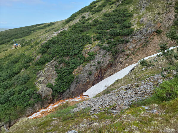
A Seward Peninsula Vista
Scenic view of the Seward Peninsula, Alaska. Photo taken from a ridge above Graphite Creek, looking northwest towards the Imruk Basin. This area of the Seward Peninsula holds the largest graphite deposit in the US known as the Graphite Creek Deposit.
Scenic view of the Seward Peninsula, Alaska. Photo taken from a ridge above Graphite Creek, looking northwest towards the Imruk Basin. This area of the Seward Peninsula holds the largest graphite deposit in the US known as the Graphite Creek Deposit.
Science and Products
Alaska Critical Mineral Resource Assessments
Alaska has potential for a wide range of critical minerals including, but not limited to, graphite, lithium, tin, tungsten, rare earth elements, and platinum-group elements.
Alaska Resource Data File
The Alaska Resource Data File (ARDF) site provides descriptions of mines, prospects, and mineral occurrences for individual U.S. Geological Survey 1:250,000-scale quadrangles in Alaska.
GIS Prospectivity Analysis for Critical Minerals in Ore-Forming Systems in Alaska
Alaska is dominated by a history of tectonic events that foster mobilization and concentration of a wide variety of mineral commodities that are critical to the US economy and are vital to national defense, renewable-energy, and emerging electronics technologies.
Mineral Resource Assessment Training
The USGS Mineral Resources Program conducts mineral resource assessments and is training USGS scientists in how to conduct these assessments for future work. As a practical exercise, the scientists will conduct an assessment for tungsten in the U.S.
Critical mineral veins
A fluorite-lepidolite-wolframite vein intersected in drill core from the Lost River Sn-W mine, Seward Peninsula, Alaska. Lepidolite is a lithium-bearing mica, and wolframite an ore of tungsten.
A fluorite-lepidolite-wolframite vein intersected in drill core from the Lost River Sn-W mine, Seward Peninsula, Alaska. Lepidolite is a lithium-bearing mica, and wolframite an ore of tungsten.
Lost River tin mine
A view of the old Lost River tin mine located on the Seward Peninsula, Alaska. The mine produced tin and tungsten from the early 20th century and ceased around 1955. The site is currently being studied by USGS for lithium potential.
A view of the old Lost River tin mine located on the Seward Peninsula, Alaska. The mine produced tin and tungsten from the early 20th century and ceased around 1955. The site is currently being studied by USGS for lithium potential.
Jack Hills Conglomerate from Western Australia
This is the Jack Hills Conglomerate from Western Australia, which yielded the oldest known zircon grains on Earth at about 4.4 billion years old.
This is the Jack Hills Conglomerate from Western Australia, which yielded the oldest known zircon grains on Earth at about 4.4 billion years old.
USGS scientists on CMMI field trip
USGS scientists George Case, Garth Graham, Anne McCafferty, and Josh Coyan visited Australia while participating in a Critical Minerals Mapping Initiative (CMMI) field trip. The CMMI is a collaborative effort between the USGS, Geological Survey of Canada, and Geoscience Australia to conduct research on mineral systems that contain critical commodities.
USGS scientists George Case, Garth Graham, Anne McCafferty, and Josh Coyan visited Australia while participating in a Critical Minerals Mapping Initiative (CMMI) field trip. The CMMI is a collaborative effort between the USGS, Geological Survey of Canada, and Geoscience Australia to conduct research on mineral systems that contain critical commodities.
Sensitive High Resolution Ion Microprobe (SHRIMP)
Scientists use the SHRIMP or sensitive high-resolution ion microprobe to measure the ration of lead to uranium (Pb/U) in order to calculate the age of the mineral grain.
Scientists use the SHRIMP or sensitive high-resolution ion microprobe to measure the ration of lead to uranium (Pb/U) in order to calculate the age of the mineral grain.
Navigating a slippery slope at Graphite Creek Deposit
Navigating a slippery slope at Graphite Creek DepositGeologist, Sue Karl, at Graphite Creek Deposit on the Seward Peninsula, Alaska. She is making field observations and measurements about the flake graphite deposit and the surrounding host rocks. These observations were used in developing a model of flake graphite genesis. Graphite is a critical mineral which the US depends entirely on imports.
Graphite Creek, namesake of the Graphite Creek deposit
Graphite Creek, namesake of the Graphite Creek depositThe Graphite Creek Deposit on the Seward Peninsula, Alaska, crops out here at Graphite Creek. Mining in this area previously took place from roughly 1900-1916. Graphite is a critical mineral which the US relies entirely on imports.
Graphite Creek adit
USGS Geologist Susan Karl investigates an outcrop of massive flake graphite (dark gray rock) at the Graphite Creek deposit located on the Seward Peninsula, Alaska. An adit, a horizontal passage leading into a mine for the purposes of access or drainage, from historical mining is visible in the corner.
USGS Geologist Susan Karl investigates an outcrop of massive flake graphite (dark gray rock) at the Graphite Creek deposit located on the Seward Peninsula, Alaska. An adit, a horizontal passage leading into a mine for the purposes of access or drainage, from historical mining is visible in the corner.
Kigluaik Mountains Gneiss Dome
View of the Kigluaik Mountains gneiss dome which is the location of the Graphite Creek Deposit. The rocks of the gneiss dome were metamorphosed to as high as granulite facies during the middle Cretaceous (ca. 100 – 90 Ma), forming flake graphite ore in the process.
View of the Kigluaik Mountains gneiss dome which is the location of the Graphite Creek Deposit. The rocks of the gneiss dome were metamorphosed to as high as granulite facies during the middle Cretaceous (ca. 100 – 90 Ma), forming flake graphite ore in the process.
A Seward Peninsula Vista
Scenic view of the Seward Peninsula, Alaska. Photo taken from a ridge above Graphite Creek, looking northwest towards the Imruk Basin. This area of the Seward Peninsula holds the largest graphite deposit in the US known as the Graphite Creek Deposit.
Scenic view of the Seward Peninsula, Alaska. Photo taken from a ridge above Graphite Creek, looking northwest towards the Imruk Basin. This area of the Seward Peninsula holds the largest graphite deposit in the US known as the Graphite Creek Deposit.