
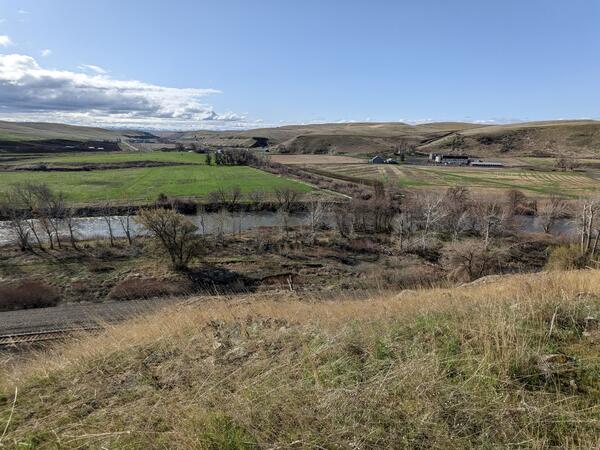
Umatilla River near Brich Creek from Rieth Road. The confluence of these two rivers is at a wide alluvial valley bounded by low hills. Birch Creek flows through the straightened ditch lined by bushes in the midground.
Heather Bervid
Heather Bervid is a Hydrologist at the USGS Oregon Water Science Center.
Heather Bervid is a Hydrologist with the Geomorphology Team at the U.S. Geological Survey Oregon Water Science Center based in Portland, OR. She began working with the USGS in June 2014 as a recipient of the National Association of Geoscience Teachers-U.S. Geological Survey Cooperative Summer Field Training Program (NAGT-USGS) and continued USGS research as a Pathways Student Intern while attending graduate school.
During her time at the USGS, Heather has worked on studies ranging from geomorphic and quaternary mapping projects to water quality and restoration monitoring. These projects include: mapping and analysis of river impoundment and lake formation upstream of the Bonneville Landslide complex, Quaternary mapping along the Columbia River Gorge, geomorphic mapping of Willamette River floodplain features, lamprey habitat surveys in the Umpqua River basin, storm bedload sampling downstream of the SR-530/Oso Landslide, vegetation re-establishment monitoring downstream of the annual Fall Creek Reservoir drawdowns, restoration effectiveness monitoring under the Willamette Focused Investment Program (FIP), and water quality sampling and monitoring for the National Water Quality Network (NWQN/NAWQA), as well as assistance with a variety of other field- and data-based projects. Her research often includes GIS compilation, interpretation of geologic and geomorphic processes, field studies in a variety of environments, and data analysis.
In addition to her work on river systems with the USGS, Heather also conducted research in the fields of glacio-fluvial systems, glacial geology, glacial geomorphology, marine sediment geochemistry, cosmogenic exposure dating, sediment transport, and landscape evolution during her time at the University of Washington and Oregon State University. While in graduate school, she was a recipient of the National Science Foundation Graduate Research Fellowship Program (NSF GRFP).
Science and Products
Alluvial reach identification and hydrogeomorphic characterization of Oregon rivers
The USGS, in partnership with the Environmental Protection Agency (EPA), is developing an objective mapping framework to systematically identify alluvial reaches in 13 river basins across Oregon to support EPA and Oregon’s Department of Environmental Quality (DEQ) in their implementation of the Clean Water Act’s water temperature Total Maximum Daily Loads (TMDLs), as well as to support the...

Willamette Focused Investment Partnership Restoration Effectiveness Monitoring Program
The USGS, in collaboration with several Willamette River Basin partners, led a multi-phase program to assess the effectiveness of restoration efforts aimed at improving native fish habitat in the Willamette River. The Willamette Focused Investment Partnership Restoration Effectiveness Monitoring Program evaluates whether restoration projects achieved their targets to improve physical floodplain...

Oregon Geomorphic Studies
Assessing channel change, habitat health, and flood hazards across Oregon rivers and streams.

Willamette River Studies
Welcome to the Willamette River Study page. Here you will find links to USGS research for the Willamette River and the Willamette River Basin.
Umatilla River near Birch Creek
Umatilla River near Brich Creek from Rieth Road. The confluence of these two rivers is at a wide alluvial valley bounded by low hills. Birch Creek flows through the straightened ditch lined by bushes in the midground.
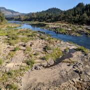
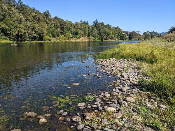
Main Umpqua River near Tyee, Oregon
Photo taken during field work along the Umpqua River.
Photo taken during field work along the Umpqua River.
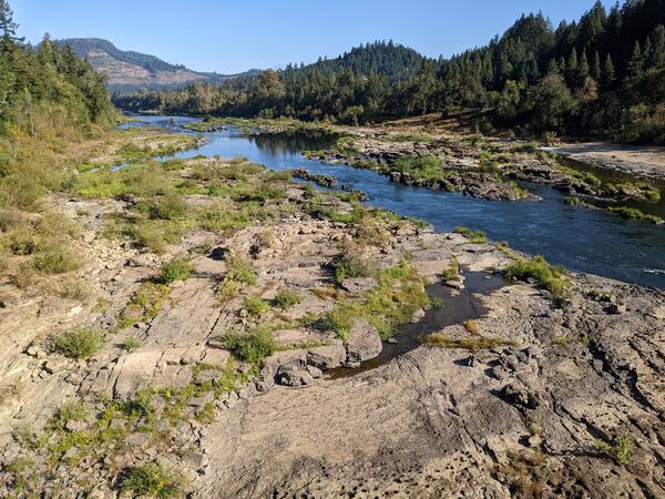
Umpqua River near Coles Valley
The main Umpqua River near Coles Valley. This section of river channel is composed of unconsolidated sediments called alluvium, which make up alluvial valleys.
The main Umpqua River near Coles Valley. This section of river channel is composed of unconsolidated sediments called alluvium, which make up alluvial valleys.
Science and Products
Alluvial reach identification and hydrogeomorphic characterization of Oregon rivers
The USGS, in partnership with the Environmental Protection Agency (EPA), is developing an objective mapping framework to systematically identify alluvial reaches in 13 river basins across Oregon to support EPA and Oregon’s Department of Environmental Quality (DEQ) in their implementation of the Clean Water Act’s water temperature Total Maximum Daily Loads (TMDLs), as well as to support the...
Willamette Focused Investment Partnership Restoration Effectiveness Monitoring Program
The USGS, in collaboration with several Willamette River Basin partners, led a multi-phase program to assess the effectiveness of restoration efforts aimed at improving native fish habitat in the Willamette River. The Willamette Focused Investment Partnership Restoration Effectiveness Monitoring Program evaluates whether restoration projects achieved their targets to improve physical floodplain...
Oregon Geomorphic Studies
Assessing channel change, habitat health, and flood hazards across Oregon rivers and streams.
Willamette River Studies
Welcome to the Willamette River Study page. Here you will find links to USGS research for the Willamette River and the Willamette River Basin.
Umatilla River near Birch Creek
Umatilla River near Brich Creek from Rieth Road. The confluence of these two rivers is at a wide alluvial valley bounded by low hills. Birch Creek flows through the straightened ditch lined by bushes in the midground.
Umatilla River near Brich Creek from Rieth Road. The confluence of these two rivers is at a wide alluvial valley bounded by low hills. Birch Creek flows through the straightened ditch lined by bushes in the midground.
Main Umpqua River near Tyee, Oregon
Photo taken during field work along the Umpqua River.
Photo taken during field work along the Umpqua River.
Umpqua River near Coles Valley
The main Umpqua River near Coles Valley. This section of river channel is composed of unconsolidated sediments called alluvium, which make up alluvial valleys.
The main Umpqua River near Coles Valley. This section of river channel is composed of unconsolidated sediments called alluvium, which make up alluvial valleys.