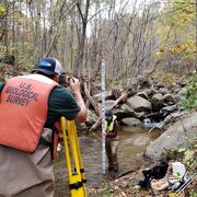
Lindsey Boyle
Lindsey is a fish biologist at the USGS Eastern Ecological Science Center Center in Kearneysville, WV
Lindsey Boyle is an aquatic ecologist whose work includes biological data management and research investigating stream biological assemblages and stressors, benthic macroinvertebrate functional traits, and trends in stream condition.
Professional Experience
2023 - Present: Fish Biologist, U.S. Geological Survey, Eastern Ecological Science Center
2020-2023: Biologist, Arkansas Department of Energy and Environment, Division of Environmental Quality
Education and Certifications
M.Sc. 2020, Zoology, University of Wyoming
B.Sc. 2015, College of William and Mary
Science and Products
Using monitoring data to measure conditions over time in Chesapeake Bay streams
This study provides a comprehensive assessment of the health of streams throughout the Chesapeake Bay. Monitoring data were used to assess seven key indicators of stream condition, revealing consistent patterns of degradation in urban and agricultural areas. The findings offer critical insights that can inform watershed restoration efforts and improve long-term monitoring strategies.
Tracking Status and Trends in Seven Key Indicators of River and Stream Condition in the Chesapeake Bay Watershed
Identifying and tracking the status of, and trends in, stream health within the Chesapeake Bay watershed is essential to understanding the past, present, and future trajectory of the watershed’s resources and ecological condition. A team of USGS scientists is meeting this need with an initiative to track the status of, and trends in, key indicators of the health of non-tidal freshwater streams...
Status and trends in stream temperature, salinity, flow, hydromorphology, and biological assemblages across the Chesapeake Bay Watershed Status and trends in stream temperature, salinity, flow, hydromorphology, and biological assemblages across the Chesapeake Bay Watershed
The Chesapeake Bay watershed is home to over 18.5 million people and continues to experience rapid population growth. With changes in population and land development, understanding current conditions of streams within the watershed (status), and changes in condition over time (trends) is important for assessing stream health. This data release contains the output files for results of...
“DelRiv 24k – LU": Land Use/Land Cover Related Data Summaries for the Delaware River Watershed Within NHD Plus HR catchments “DelRiv 24k – LU": Land Use/Land Cover Related Data Summaries for the Delaware River Watershed Within NHD Plus HR catchments
These tabular data are the summarization of land use/land cover related variables within the Delaware River watershed at the 1:24,000 scale using the xstrm methodology. Variables being counted as land use/land cover related include all land use and land cover data. Outputs consist of tabular comma-separated values files (CSVs), and parquet formatted files for both the local catchment and...
“DelRiv 24k – NE": Natural Environment Related Data Summaries for the Delaware River Watershed Within NHD Plus HR catchments “DelRiv 24k – NE": Natural Environment Related Data Summaries for the Delaware River Watershed Within NHD Plus HR catchments
These tabular data are the summarization of natural environment related variables within catchments of the Delaware River watershed at the 1:24,000 scale using the xstrm methodology. Variables being counted as natural environment related include soils/geology, lithology, elevation, slope, landform (geomorphon) and others. Outputs include tabular comma-separated values files (CSVs) and...
Attribution of benthic macroinvertebrate sampling data to NHDPlus V2 and NHDPlus HR catchments within the Chesapeake Bay Watershed Attribution of benthic macroinvertebrate sampling data to NHDPlus V2 and NHDPlus HR catchments within the Chesapeake Bay Watershed
This data release links benthic macroinvertebrate sites to both the NHDPlus Version 2 and NHDPlus High Resolution Region 02 networks, hereafter referred to as V2 and HR, using the hydrolink methodology. Linked benthic macroinvertebrate sites are those included in the Chesapeake Bay Basin-wide Index of Biotic Integrity (Chessie BIBI) developed by the Interstate Commission on the Potomac...
Attribution of stream habitat assessment data to NHDPlus V2 and NHDPlus HR catchments within the Chesapeake Bay Watershed Attribution of stream habitat assessment data to NHDPlus V2 and NHDPlus HR catchments within the Chesapeake Bay Watershed
This data release links habitat assessment sites to both the NHDPlus Version 2 and NHDPlus High Resolution Region 02 networks using the hydrolink methodology. Linked habitat sites are those compiled by the Interstate Commission on the Potomac River Basin (ICPRB) during creation of the Chesapeake Bay Basin-wide Index of Biotic Integrity (Chessie BIBI) for benthic macroinvertebrates (https...
Attribution of fish sampling data to NHDPlus HR catchments within the Chesapeake Bay Watershed Attribution of fish sampling data to NHDPlus HR catchments within the Chesapeake Bay Watershed
This data release links fish survey data from a suite of programs in the Chesapeake Bay watershed to the NHDPlus High Resolution Region 02 networks, hereafter referred to as NHDPlusHR. The data set contains site name, survey program, coordinates of sample, ancillary information such as sample date and site location information where available, and HR Permanent Identifier. It also...
Tracking status and trends in seven key indicators of river and stream condition in the Chesapeake Bay watershed Tracking status and trends in seven key indicators of river and stream condition in the Chesapeake Bay watershed
Freshwater streams and rivers are recognized as vital habitats within the Chesapeake Bay watershed, which has been undergoing extensive restoration efforts for more than 30 years. Resource managers need to understand stream and river condition and how these conditions are changing over time to determine whether regional long-term restoration and conservation goals are being met. The...
Authors
Lindsey Boyle, Samuel Austin, Matthew Cashman, Zachary Clifton, John Clune, James Colgin, Kaitlyn Elliott, Rosemary Fanelli, Ellie Foss, Nathaniel Hitt, Elizabeth Hittle, Coral Howe, Emily Majcher, Kelly Maloney, Christopher Mason, Marina Metes, Douglas Moyer, Trevor Needham, Karli Rogers, Joshua Thompson, Guoxiang Yang, Tammy Zimmerman